Login
Register


T85
Yoakum Municipal Airport
Official FAA Data Effective 2025-11-27 0901Z
Chart Supplement

VFR Chart of T85
Sectional Charts at SkyVector.com
IFR Chart of T85
Enroute Charts at SkyVector.com
Location Information for T85
Coordinates: N29°18.79' / W97°8.31'Located 01 miles N of Yoakum, Texas on 92 acres of land. View all Airports in Texas.
Surveyed Elevation is 365 feet MSL.
Operations Data
|
|
Airport Communications
| CTAF: | 122.900 |
|---|---|
| AWOS-3 at T20 (21.4 NW): | 125.875 830-519-4254 |
| ASOS at VCT (29.2 S): | 361-433-5979 |
| ATIS at VCT (29.9 S): | 119.025 |
- APCH/DEP CTL SVC PRVDD BY HOUSTON ARTCC (ZHU) ON FREQS 132.8/343.7 (SAN ANTONIO RCAG).
Nearby Navigation Aids
|
| ||||||||||||||||||||||||||||||||||||||||||||||||


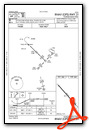
Runway 13/31
| Dimensions: | 3444 x 60 feet / 1050 x 18 meters | |
|---|---|---|
| Surface: | Asphalt in Fair Condition | |
| Weight Limits: | S-12 | |
| Edge Lighting: | Medium Intensity | |
| Runway 13 | Runway 31 | |
| Coordinates: | N29°18.99' / W97°8.54' | N29°18.59' / W97°8.07' |
| Elevation: | 365.1 | 341.1 |
| Traffic Pattern: | Left | Left |
| Runway Heading: | 134° True | 314° True |
| Markings: | Non-Precision Instrument in poor condition. | Non-Precision Instrument in poor condition. |
| Obstacles: | 45 ft Pole 998 ft from runway, 230 ft left of center | 42 ft Pole 1230 ft from runway, 170 ft right of center |
Services Available
| Fuel: | NONE |
|---|---|
| Transient Storage: | Tiedowns |
| Airframe Repair: | NOT AVAILABLE |
| Engine Repair: | NOT AVAILABLE |
| Bottled Oxygen: | NOT AVAILABLE |
| Bulk Oxygen: | NOT AVAILABLE |
Ownership Information
| Ownership: | Publicly owned | |
|---|---|---|
| Owner: | CITY OF YOAKUM | |
| PO BOX 738 | ||
| YOAKUM, TX 77995 | ||
| 361-293-6321 | ||
| Manager: | MICHAEL MITCHELL | |
| PO BOX 738 | ||
| YOAKUM, TX 77995-0738 | ||
| 361-293-6321 | ||
Other Remarks
- FOR CD CTC HOUSTON ARTCC AT 281-230-5622.
- RWY MRKGS FADED.
- RWY MRKGS FADED.
Weather Minimums
Instrument Approach Procedure (IAP) Charts
Nearby Airports with Instrument Procedures
| ID | Name | Heading / Distance | ||
|---|---|---|---|---|
 |
KVCT | Victoria Regional Airport | 157° | 29.8 |
|
26R | Jackson County Airport | 122° | 34.7 |
|
3T5 | Fayette Regional Air Center Airport | 015° | 36.9 |
|
50R | Lockhart Municipal Airport | 319° | 42.6 |
|
84R | Smithville Crawford Municipal Airport | 358° | 42.8 |
|
KELA | Eagle Lake Airport | 067° | 46.1 |
|
KPKV | Calhoun County Airport | 148° | 46.2 |
|
2R9 | Kenedy Regional Airport | 232° | 48.1 |
|
KHYI | San Marcos Regional Airport | 312° | 51.4 |
|
KARM | Wharton Regional Airport | 093° | 51.8 |
|
KGYB | Giddings-Lee County Airport | 009° | 51.9 |
|
KBAZ | New Braunfels Ntl Airport | 296° | 52.9 |
Airport Images
Do you have a recent image of this airport? Upload it here!


