Login
Register


OGA
Searle Field Airport
Official FAA Data Effective 2025-12-25 0901Z
Chart Supplement

VFR Chart of KOGA
Sectional Charts at SkyVector.com
IFR Chart of KOGA
Enroute Charts at SkyVector.com
Location Information for KOGA
Coordinates: N41°7.17' / W101°46.18'Located 02 miles W of Ogallala, Nebraska on 281 acres of land. View all Airports in Nebraska.
Surveyed Elevation is 3279 feet MSL.
Operations Data
|
|
Airport Communications
| AWOS-3: | 121.275 Tel. 308-284-6573 |
|---|---|
| CTAF: | 122.800 |
| UNICOM: | 122.800 |
| AWOS-3PT at GGF (15.0 S): | 118.025 308-352-4689 |
| ASOS at IML (37.2 S): | 124.175 308-882-5186 |
| AWOS-3 at HEQ (40.2 SW): | 119.275 970-854-3679 |
- APCH/DEP CTL SVC PRVDD BY DENVER ARTCC (ZDV) ON FREQS 132.7/397.85 (OGALLALA RCAG).
Nearby Navigation Aids
|
| ||||||||||||||||||||||||||||||||||||||||||||||||||||||


Runway 08/26
| Dimensions: | 5102 x 75 feet / 1555 x 23 meters | |
|---|---|---|
| Surface: | Concrete in Good Condition | |
| Weight Limits: | S-12, D-12 | |
| Edge Lighting: | Medium Intensity | |
| Runway 08 | Runway 26 | |
| Coordinates: | N41°7.07' / W101°46.87' | N41°7.07' / W101°45.76' |
| Elevation: | 3260.5 | 3245.0 |
| Traffic Pattern: | Left | Left |
| Runway Heading: | 90° True | 270° True |
| Markings: | Non-Precision Instrument in good condition. | Non-Precision Instrument in good condition. |
| Glide Slope Indicator | P2L (3.00° Glide Path Angle) | P2L (3.00° Glide Path Angle) |
Runway 13/31
| Dimensions: | 3700 x 60 feet / 1128 x 18 meters | |
|---|---|---|
| Surface: | Concrete in Excellent Condition | |
| Weight Limits: | S-12, D-12 | |
| Edge Lighting: | Medium Intensity | |
| Runway 13 | Runway 31 | |
| Coordinates: | N41°7.55' / W101°46.24' | N41°7.06' / W101°45.77' |
| Elevation: | 3279.3 | 3244.8 |
| Traffic Pattern: | Left | Left |
| Runway Heading: | 144° True | 324° True |
| Markings: | Non-Precision Instrument in good condition. | Non-Precision Instrument in good condition. |
| Glide Slope Indicator | V4L (3.50° Glide Path Angle) | P2L (3.00° Glide Path Angle) |
| Obstacles: | 30 ft Road 670 ft from runway, 320 ft left of center | |
Services Available
| Fuel: | 100LL (blue), Jet A+ |
|---|---|
| Transient Storage: | Hangars,Tiedowns |
| Airframe Repair: | MAJOR |
| Engine Repair: | MAJOR |
| Bottled Oxygen: | HIGH |
| Bulk Oxygen: | NOT AVAILABLE |
| Other Services: | CROP DUSTING SERVICES |
Ownership Information
| Ownership: | Publicly owned | |
|---|---|---|
| Owner: | CITY OF OGALLALA | |
| 411 E 2ND STREET | ||
| OGALLALA, NE 69153-2631 | ||
| 308-284-6001 | ||
| Manager: | KEVIN WILKINS | KEVIN.WILKINS@OGALLALA-NE.GOV |
| 411 E 2ND STREET | ||
| OGALLALA, NE 69153-2631 | ||
| 308-284-6001 | ||
Other Remarks
- FOR CD IF UNA TO CTC ON FSS FREQ, CTC DENVER ARTCC AT 303-651-4257.
- CALM WIND RWY.
- ACTVT PAPI RWY 08, 26 & 31; VASI RWY 13; MIRL RWY 13/31 & 08/26 - CTAF.
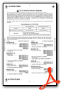
Weather Minimums
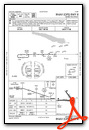
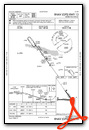
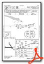
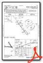
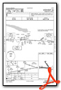
Instrument Approach Procedure (IAP) Charts
Nearby Airports with Instrument Procedures
| ID | Name | Heading / Distance | ||
|---|---|---|---|---|
 |
KGGF | Grant Municipal Airport | 173° | 15.0 |
|
KOKS | Garden County/King Rhiley Field Airport | 302° | 31.5 |
|
KIML | Imperial Municipal Airport | 169° | 37.2 |
|
KHEQ | Holyoke Airport | 214° | 40.2 |
|
KLBF | North Platte Regional/Lee Bird Field Airport | 089° | 49.2 |
|
KSNY | Sidney Municipal/Lloyd W Carr Field Airport | 269° | 55.1 |
|
2V5 | Wray Municipal Airport | 199° | 64.8 |
|
47V | Curtis Municipal Airport | 115° | 65.7 |
|
KAIA | Alliance Municipal Airport | 320° | 72.8 |
|
KTIF | Thomas County Airport | 046° | 74.0 |
|
KSTK | Sterling Municipal Airport | 246° | 74.5 |
|
KGTE | Gothenburg Municipal Airport | 098° | 74.6 |
Airport Images
Do you have a recent image of this airport? Upload it here!


