Login
Register


TPH
Tonopah Airport
Official FAA Data Effective 2026-01-22 0901Z
Chart Supplement

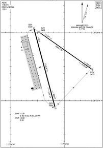
KTPH Airport Diagram
VFR Chart of KTPH
Sectional Charts at SkyVector.com
IFR Chart of KTPH
Enroute Charts at SkyVector.com
Location Information for KTPH
Coordinates: N38°3.59' / W117°5.20'Located 07 miles E of Tonopah, Nevada on 3820 acres of land. View all Airports in Nevada.
Surveyed Elevation is 5430 feet MSL.
Operations Data
|
|
Airport Communications
| ASOS: | 118.875 Tel. 775-482-3441 |
|---|---|
| UNICOM: | 123.000 |
| CTAF: | 123.000 |
| ASOS at BIH (73.2 SW): | 119.025 760-227-6035 |
| AWOS-3 at HTH (78.4 NW): | 120.225 775-945-0727 |
| AWOS-3PT at MMH (87.1 W): | 118.05 760-934-6020 |
Nearby Navigation Aids
|
| ||||||||||||||||||||||||||||||||||||


Runway 15/33
| Dimensions: | 7160 x 75 feet / 2182 x 23 meters | |
|---|---|---|
| Surface: | Asphalt in Excellent Condition | |
| Weight Limits: | S-30 | |
| Edge Lighting: | Medium Intensity | |
| Runway 15 | Runway 33 | |
| Coordinates: | N38°4.05' / W117°5.56' | N38°2.91' / W117°5.18' |
| Elevation: | 5430.2 | 5396.0 |
| Traffic Pattern: | Left | Left |
| Runway Heading: | 165° True | 345° True |
| Markings: | Non-Precision Instrument in good condition. | Non-Precision Instrument in good condition. |
| Glide Slope Indicator | P2L (3.00° Glide Path Angle) | |
Runway 11/29
| Dimensions: | 5660 x 50 feet / 1725 x 15 meters | |
|---|---|---|
| Surface: | Asphalt in Failed Condition RWY CRACKING FULL-LEN; LATERAL & LONGL CRACKS IN EXCESS OF 4 INCHES. | |
| Weight Limits: | S-30, D-66, ST-77 | |
| Edge Lighting: | Medium Intensity | |
| Runway 11 | Runway 29 | |
| Coordinates: | N38°4.00' / W117°5.46' | N38°3.47' / W117°4.49' |
| Elevation: | 5428.4 | 5410.4 |
| Traffic Pattern: | Left | Left |
| Runway Heading: | 125° True | 305° True |
| Markings: | Basic in fair condition. | Basic in fair condition. |
Helipad H1
| Dimensions: | 48 x 48 feet / 15 x 15 meters | |
|---|---|---|
| Surface: | Asphalt / Aggregate Friction Seal Coated in Good Condition | |
| Coordinates: | N38°3.76' / W117°5.68' | N0°0.00' / E0°0.00' |
| Elevation: | 5420.1 | |
| Markings: | Non-Standard in good condition. | |
Services Available
| Fuel: | 100LL (blue), Jet-A |
|---|---|
| Transient Storage: | Buoys,Tiedowns |
| Airframe Repair: | MAJOR |
| Engine Repair: | MAJOR |
| Bottled Oxygen: | LOW |
| Bulk Oxygen: | NONE |
| Other Services: | AIR AMBULANCE SERVICES |
Ownership Information
| Ownership: | Publicly owned | |
|---|---|---|
| Owner: | NYE COUNTY | EMERG CTC 775-513-3107. |
| P O BOX 1031 | ||
| TONOPAH, NV 89049 | ||
| (775) 209-4174 | OTR CTC (775) 482-3626. | |
| Manager: | THOMAS BOLLING | |
| 2041 E. CALVADA BLVD. N. SUITE #3 | ||
| PAHRUMP, NV 89048 | ||
| 775-751-6270 | ||
Other Remarks
- FOR CD, IF UNA TO CTC ON FSS FREQ, CTC NELLIS APCH AT 702-652-4172.
- FATO & "H" MARKED IN YELLOW
- FADED YELLOW OUTLINE.
- 0LL FUEL AVBL 0700-1800; AFT HRS O/R CALL (775) 482-3626.
- ACTVT PAPI RWY 15; MIRL RWY 15/33 & 11/29 - CTAF.
Weather Minimums

Instrument Approach Procedure (IAP) Charts
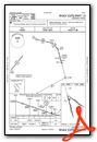

Nearby Airports with Instrument Procedures
| ID | Name | Heading / Distance | ||
|---|---|---|---|---|
 |
KTNX | Tonopah Test Range Airport | 137° | 21.3 |
|
KBIH | Bishop Airport | 236° | 73.4 |
|
KHTH | Hawthorne Industrial Airport | 292° | 78.6 |
|
KMMH | Mammoth Yosemite Airport | 253° | 87.3 |
|
05U | Eureka Airport | 028° | 105.6 |
|
O43 | Yerington Municipal Airport | 300° | 112.7 |
|
KFLX | Fallon Municipal Airport | 318° | 116.3 |
|
KELY | Ely/Yelland Field Airport | 054° | 129.0 |
|
KSPZ | Silver Springs Airport | 309° | 129.6 |
|
KMEV | Minden-Tahoe Airport | 295° | 137.5 |
|
O32 | Reedley Municipal Airport | 234° | 140.4 |
|
KCXP | Carson City Airport | 299° | 141.7 |
Airport Images
Do you have a recent image of this airport? Upload it here!


