Login
Register
UIL
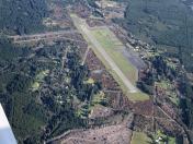
Quillayute Airport
Official FAA Data Effective 2026-01-22 0901Z
VFR Chart of KUIL
Sectional Charts at SkyVector.com
IFR Chart of KUIL
Enroute Charts at SkyVector.com
Location Information for KUIL
Coordinates: N47°56.19' / W124°33.76'Located 07 miles E of Quillayute, Washington on 739 acres of land. View all Airports in Washington.
Surveyed Elevation is 194 feet MSL.
Operations Data
|
|
Airport Communications
| ASOS: | 135.225 Tel. 360-374-9731 |
|---|---|
| CTAF: | 122.900 |
| ASOS at CLM (43.8 E): | 135.175 360-457-1070 |
| AWOS-3P at NOW (48.1 E): | 118.325 360-457-7529 |
| ATIS at CYYJ (62.3 NE): | 118.8 |
Nearby Navigation Aids
|
| ||||||||||||||||||||||||||||||||||||||||||
Runway 04/22
| Dimensions: | 4211 x 100 feet / 1284 x 30 meters | |
|---|---|---|
| Surface: | Concrete in Good Condition | |
| Weight Limits: | S-30, D-50 | |
| Runway 04 | Runway 22 | |
| Coordinates: | N47°56.01' / W124°34.20' | N47°56.38' / W124°33.32' |
| Elevation: | 176.4 | 194.1 |
| Traffic Pattern: | Left | Left |
| Runway Heading: | 58° True | 238° True |
| Markings: | Basic in fair condition. | Basic in fair condition. |
| Obstacles: | 70 ft Trees 1535 ft from runway | |
Services Available
| Fuel: | NONE |
|---|---|
| Transient Storage: | Tiedowns PILOTS BRING OWN TIEDOWNS. |
| Airframe Repair: | NONE |
| Engine Repair: | NONE |
| Bottled Oxygen: | NONE |
| Bulk Oxygen: | NONE |
Ownership Information
| Ownership: | Publicly owned | |
|---|---|---|
| Owner: | CITY OF FORKS | |
| 500 EAST DIVISION ST. | ||
| FORKS, WA 98331 | ||
| 360-374-5412 | EXT 245. | |
| Manager: | ROD FLECK | |
| 500 EAST DIVISION ST. | ||
| FORKS, WA 98331 | ||
| 360-374-5412 | ||
Other Remarks
- PEDESTRIANS; VEHICLES & ANIMALS ON & INVOF RY.
- 4 FT SQUARE GRATED DRAIN ON N SIDE OF APRON.
- FOR CD CTC SEATTLE ARTCC AT 253-351-3694.
Nearby Airports with Instrument Procedures
| ID | Name | Heading / Distance | ||
|---|---|---|---|---|
 |
KCLM | William R Fairchild International Airport | 075° | 44.2 |
 |
KNOW | Port Angeles CGAS Airport | 074° | 47.9 |
 |
CYYJ | Victoria International Airport | 046° | 62.4 |
 |
KHQM | Bowerman Field Airport | 156° | 63.3 |
 |
0S9 | Jefferson County International Airport | 083° | 70.9 |
 |
KFHR | Friday Harbor Airport | 059° | 71.0 |
 |
KSHN | Sanderson Field Airport | 125° | 71.3 |
 |
CYCD | Nanaimo Airport | 022° | 72.6 |
 |
KPWT | Bremerton Ntl Airport | 109° | 77.6 |
 |
KOKH | Delaurentis Airport | 075° | 78.3 |
 |
KNUW | Whidbey Island NAS (Ault Field) Airport | 071° | 80.6 |
 |
KORS | Orcas Island Airport | 054° | 80.8 |


Comments
June 25th Stop at KUIL
We stopped at KUIL for a passport stamp. Runway is in great condition, but once we turned off onto the taxiway and ramp, we mowed a fair bit of grass (no charge to the state) as the pavement is cracked and weeds abound! Not a person in sight and super quiet, which was kind of relaxing.
There is a port-a-potty in the small white shack at the NE corner of the ramp right next to the WPA passport box, it was in need of service, but I've seen worse.
Minus a passport stamp or just needing to stretch your legs, not much reason to stop here unless maybe one of the local fishing guides or the area lodges will pick you up. There are several little bunk-house camps and lodges shown on Google maps.
About 5 minutes East is Forks (S18). Probably a better choice if you are looking for a few basic services. There is plenty within easy walking distance of the Forks airport.
Star Gazing
No light pollution. Land and watch meteor showers in the summer if the marine layer isn't there.