Login
Register


GUY
Guymon Municipal Airport
Official FAA Data Effective 2026-01-22 0901Z
Chart Supplement

VFR Chart of KGUY
Sectional Charts at SkyVector.com
IFR Chart of KGUY
Enroute Charts at SkyVector.com
Location Information for KGUY
Coordinates: N36°41.05' / W101°30.42'Located 01 miles W of Guymon, Oklahoma on 480 acres of land. View all Airports in Oklahoma.
Surveyed Elevation is 3125 feet MSL.
Operations Data
|
|
Airport Communications
| ASOS: | 119.925 Tel. 580-754-2113 |
|---|---|
| CTAF: | 122.700 |
| UNICOM: | 122.700 |
| AWOS-3P at EHA (26.1 NW): | 118.025 620-697-4973 |
| AWOS-3PT at HQG (29.6 N): | 118.600 620-544-4000 |
| AWOS-3P at E42 (31.8 SE): | 118.925 806-644-6824 |
- APCH/DEP CTL SVC PRVDD BY KANSAS CITY ARTCC (ZKC) ON FREQS 134.0/257.625 (LIBERAL RCAG).
Nearby Navigation Aids
|
| ||||||||||||||||||||||||||||||||||||||||||||||||||||||


Runway 18/36
| Dimensions: | 5904 x 100 feet / 1800 x 30 meters | |
|---|---|---|
| Surface: | Asphalt in Excellent Condition | |
| Weight Limits: | S-10
PCR VALUE: 130/F/D/X/T
| |
| Edge Lighting: | Medium Intensity | |
| Runway 18 | Runway 36 | |
| Coordinates: | N36°41.59' / W101°30.40' | N36°40.62' / W101°30.53' |
| Elevation: | 3102.8 | 3109.4 |
| Traffic Pattern: | Right | Left |
| Runway Heading: | 186° True | 6° True |
| Markings: | Non-Precision Instrument in good condition. | Non-Precision Instrument in good condition. |
| Glide Slope Indicator | V4L (3.00° Glide Path Angle) | P4L (3.00° Glide Path Angle) |
| Approach Lights: | ODALS Omnidirectional Approach Lighting System | |
| Obstacles: | 19 ft Tree 368 ft from runway, 156 ft left of center | |
Runway 06/24
RWY 06 DEP NA. | ||
| Dimensions: | 1795 x 200 feet / 547 x 61 meters | |
|---|---|---|
| Surface: | Turf in Fair Condition | |
| Runway 06 | Runway 24 | |
| Coordinates: | N36°40.83' / W101°30.43' | N36°40.91' / W101°30.08' |
| Elevation: | 3115.0 | 3092.0 |
| Traffic Pattern: | Left | Left |
| Runway Heading: | 74° True | 254° True |
| Markings: | None in fair condition. | None in fair condition. |
Services Available
| Fuel: | 100LL (blue), Jet A+ |
|---|---|
| Transient Storage: | Hangars,Tiedowns |
| Airframe Repair: | MAJOR |
| Engine Repair: | MAJOR |
| Bottled Oxygen: | NONE |
| Bulk Oxygen: | HIGH/LOW |
| Other Services: | CROP DUSTING SERVICES,AIR AMBULANCE SERVICES,CARGO HANDLING SERVICES,PILOT INSTRUCTION,AIRCRAFT RENTAL |
Ownership Information
| Ownership: | Publicly owned | |
|---|---|---|
| Owner: | CITY OF GUYMON | |
| 424 N MAIN | ||
| GUYMON, OK 73942 | ||
| 580-338-3396 | ||
| Manager: | GREGG R DOWNING | |
| PO BOX 1510 | ||
| GUYMON, OK 73942 | ||
| 580-338-7700 | ||
Other Remarks
- ARPT COURTESY CAR AVBL.
- NUMEROUS WATERFOWL INVOF ARPT SR & SS.
- FOR CD CTC KANSAS CITY ARTCC AT 913-254-8508.
- EDGES MARKED W/ RAISED WOODEN MRKRS.
- ACTVT ODALS RWY 18; VASI RWY 18; PAPI RWY 36; MIRL RWY 18/36 - CTAF. MIRL RWY 18/36 PRESET LOW INTST, INCR INTST - CTAF.
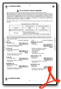
Weather Minimums

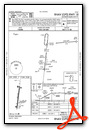
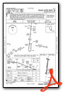
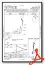
Instrument Approach Procedure (IAP) Charts
Nearby Airports with Instrument Procedures
| ID | Name | Heading / Distance | ||
|---|---|---|---|---|
 |
KEHA | Elkhart-Morton County Airport | 316° | 26.1 |
|
E19 | Gruver Municipal Airport | 172° | 27.2 |
|
KHQG | Hugoton Municipal Airport | 012° | 29.5 |
|
E42 | Major Samuel B Cornelius Field Airport | 151° | 31.6 |
|
KLBL | Liberal Mid-America Regional Airport | 050° | 34.0 |
|
KPYX | Perryton Ochiltree County Airport | 113° | 40.0 |
|
17K | Boise City Airport | 276° | 48.7 |
|
KJHN | Stanton County Municipal Airport | 348° | 55.1 |
|
KDUX | Moore County Airport | 206° | 55.3 |
|
KULS | Ulysses Airport | 006° | 55.5 |
|
KBGD | Hutchinson County Airport | 174° | 59.2 |
|
KDHT | Dalhart Municipal Airport | 232° | 64.1 |
Airport Images
Do you have a recent image of this airport? Upload it here!


