
Login
Register


EHA
Elkhart-Morton County Airport
Official FAA Data Effective 2026-02-19 0901Z
Chart Supplement

VFR Chart of KEHA
Sectional Charts at SkyVector.com
IFR Chart of KEHA
Enroute Charts at SkyVector.com
Location Information for KEHA
Coordinates: N37°0.05' / W101°52.80'Located 01 miles E of Elkhart, Kansas on 346 acres of land. View all Airports in Kansas.
Surveyed Elevation is 3621 feet MSL.
Operations Data
|
|
Airport Communications
| AWOS-3P: | 118.025 Tel. 620-697-4973 |
|---|---|
| CTAF: | 122.800 |
| UNICOM: | 122.800 |
| ASOS at GUY (26.1 SE): | 119.925 580-754-2113 |
| AWOS-3PT at HQG (26.3 E): | 118.600 620-544-4000 |
| AWOS-3PT at JHN (35.4 N): | 124.175 620-492-2100 |
- APCH/DEP CTL SVC PRVDD BY KANSAS CITY ARTCC (ZKC) ON FREQS 134.0/257.625 (LIBERAL RCAG).
Nearby Navigation Aids
|
| ||||||||||||||||||||||||||||||||||||||||||||||||||||||


Runway 17/35
| Dimensions: | 4907 x 75 feet / 1496 x 23 meters | |
|---|---|---|
| Surface: | Concrete in Excellent Condition | |
| Weight Limits: | 11 /R/C/X/U, S-30, D-30 | |
| Edge Lighting: | Medium Intensity | |
| Runway 17 | Runway 35 | |
| Coordinates: | N37°0.52' / W101°52.93' | N36°59.71' / W101°52.92' |
| Elevation: | 3607.6 | 3617.6 |
| Traffic Pattern: | Left | Right |
| Runway Heading: | 179° True | 359° True |
| Markings: | Non-Precision Instrument in good condition. | Non-Precision Instrument in good condition. |
| Glide Slope Indicator | P4L (3.00° Glide Path Angle) | P4L (3.00° Glide Path Angle) |
| Obstacles: | 18 ft Pole 917 ft from runway, 100 ft right of center | 15 ft Road 506 ft from runway |
Runway 04/22
| Dimensions: | 4900 x 60 feet / 1494 x 18 meters | |
|---|---|---|
| Surface: | Asphalt in Fair Condition | |
| Weight Limits: | 5 /F/C/Y/U | |
| Edge Lighting: | Medium Intensity | |
| Runway 04 | Runway 22 | |
| Coordinates: | N36°59.71' / W101°53.05' | N37°0.25' / W101°52.30' |
| Elevation: | 3621.8 | 3594.1 |
| Traffic Pattern: | Right | |
| Runway Heading: | 48° True | 228° True |
| Markings: | Non-Precision Instrument in good condition. | Non-Precision Instrument in good condition. |
| Glide Slope Indicator | P4L (3.00° Glide Path Angle) | P4L (3.00° Glide Path Angle) |
| Obstacles: | 15 ft Road 546 ft from runway | 21 ft Tower 279 ft from runway PIVOT IRRIGATION TWR (MOVING WHEN IN OPN). |
Services Available
| Fuel: | 100LL (blue) |
|---|---|
| Transient Storage: | Hangars,Tiedowns |
| Airframe Repair: | NOT AVAILABLE |
| Engine Repair: | NOT AVAILABLE |
| Bottled Oxygen: | NONE |
| Bulk Oxygen: | NONE |
| Other Services: | CROP DUSTING SERVICES,PILOT INSTRUCTION |
Ownership Information
| Ownership: | Publicly owned | |
|---|---|---|
| Owner: | MORTON COUNTY | |
| P.O. BOX 1116 | ||
| ELKHART, KS 67950 | ||
| 620-697-2157 | ||
| Manager: | DENNIS TEVEBAUGH | |
| PO BOX 392 | ||
| ELKHART, KS 67950 | ||
| (620) 360-6100 | CELL PHONE # 620-360-3600. | |
Other Remarks
- PUBLIC PHONE (620) 697-9803.
- FOR CD CTC KANSAS CITY ARTCC AT 913-254-8508.
- 0LL FOR FUEL CALL (620) 697-2803.
- ACTVT PAPI RWY 04, 17, 22 & 35; MIRL RWY 04/22 & 17/35 - CTAF.
Weather Minimums
Instrument Approach Procedure (IAP) Charts


Nearby Airports with Instrument Procedures
| ID | Name | Heading / Distance | ||
|---|---|---|---|---|
 |
KGUY | Guymon Municipal Airport | 136° | 26.1 |
|
KHQG | Hugoton Municipal Airport | 068° | 26.3 |
|
17K | Boise City Airport | 246° | 33.2 |
|
KJHN | Stanton County Municipal Airport | 011° | 35.7 |
|
KULS | Ulysses Airport | 033° | 43.5 |
|
KLBL | Liberal Mid-America Regional Airport | 086° | 44.3 |
|
8V7 | Springfield Municipal Airport | 308° | 44.8 |
|
E19 | Gruver Municipal Airport | 154° | 50.8 |
|
E42 | Major Samuel B Cornelius Field Airport | 144° | 57.3 |
|
3K3 | Syracuse-Hamilton County Municipal Airport | 005° | 60.1 |
|
KPYX | Perryton Ochiltree County Airport | 122° | 64.8 |
|
KDHT | Dalhart Municipal Airport | 209° | 66.9 |
Airport Images
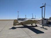
By: brb



Comments
Golf Next Door
Nice little airport with good runways. Pilots lounge and courtesy car available. Walking into town is also an easy option, as the airport sits right against its southeast corner. The Point Rock Golf Course is literally right next door. Tie down and play a few rounds. Very competitive fuel prices. A decent stopover.