Login
Register


WN13
Vaughan Ranch Airfield Airport
Official FAA Data Effective 2026-02-19 0901Z
VFR Chart of WN13
Sectional Charts at SkyVector.com
IFR Chart of WN13
Enroute Charts at SkyVector.com
Location Information for WN13
Coordinates: N47°27.82' / W122°34.14'Located 05 miles SE of Port Orchard, Washington on 3 acres of land. View all Airports in Washington.
Estimated Elevation is 240 feet MSL.
Operations Data
|
|
Airport Communications
| AWOS-3PT at PWT (7.9 W): | 121.2 360-674-2811 |
|---|---|
| D-ATIS at SEA (10.5 E): | 118.0 |
| ASOS at SEA (10.5 E): | 206-214-2592 |
Nearby Navigation Aids
|
| ||||||||||||||||||||||||||||||||||||||||||||||||


Runway 02/20
| Dimensions: | 1850 x 50 feet / 564 x 15 meters | |
|---|---|---|
| Surface: | Turf | |
| Runway 02 | Runway 20 | |
| Obstacles: | 60 ft Tree 400 ft from runway | 50 ft Tree 400 ft from runway |
Ownership Information
| Ownership: | Privately Owned | |
|---|---|---|
| Owner: | VAUGHAN RANCH HOMEOWNERS ASSN | |
| P.O. BOX 154 | ||
| OLALLA, WA 98359 | ||
| 253-858-4008 | ||
| Manager: | JAY VILLALVA | HOMEOWNERS ASSOCIATION SECRETARY. |
| PO BOX 154 | ||
| OLALLA,, WA 00983 | ||
| 360-674-8233 | ||
Other Remarks
- LAND NORTH TAKEOFF SOUTH.
- LANDING NORTH UPHILL.
- NORMAL PREVAILING WINDS ARE FROM SOUTHWEST.
- RY 02 HAS TERRAIN DROP OFF ON BOTH SIDES OF RY AND DIRT BANK ON LEFT SIDE.
- ANIMALS, DOMESTIC AND WILD, IN VICINITY OF ARPT.
- TREES BOTH SIDES OF RY.
- FOR CD CTC SEATTLE APCH AT 206-214-4794.
Nearby Airports with Instrument Procedures
| ID | Name | Heading / Distance | ||
|---|---|---|---|---|
 |
KPWT | Bremerton Ntl Airport | 281° | 8.1 |
|
KSEA | Seattle-Tacoma International Airport | 094° | 10.5 |
|
KBFI | Boeing Field/King County International Airport | 069° | 11.6 |
|
KTIW | Tacoma Narrows Airport | 181° | 11.8 |
|
KRNT | Renton Municipal Airport | 082° | 14.5 |
|
S50 | Auburn Municipal Airport | 120° | 16.2 |
|
KTCM | Mcchord Field (Joint Base Lewis-Mcchord) Airport | 169° | 19.9 |
|
KGRF | Gray AAF (Joint Base Lewis-Mcchord) Airport | 181° | 23.1 |
|
KPLU | Pierce County/Thun Field Airport | 151° | 24.5 |
|
KSHN | Sanderson Field Airport | 239° | 27.3 |
|
KPAE | Seattle Paine Field International Airport | 023° | 29.1 |
|
S43 | Harvey Field Airport | 035° | 32.5 |
Airport Images
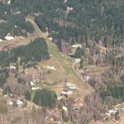
By: 22blades


