Login
Register


6R3
Cleveland Municipal Airport
Official FAA Data Effective 2025-01-23 0901Z
Chart Supplement

VFR Chart of 6R3
Sectional Charts at SkyVector.com
IFR Chart of 6R3
Enroute Charts at SkyVector.com
Location Information for 6R3
Coordinates: N30°21.39' / W95°0.48'Located 04 miles NE of Cleveland, Texas on 200 acres of land. View all Airports in Texas.
Surveyed Elevation is 150 feet MSL.
Operations Data
|
|
Airport Communications
| AWOS-3: | 119.325 Tel. 281-593-1754 |
|---|---|
| HOUSTON APPROACH: | 119.7 281.4 |
| HOUSTON DEPARTURE: | 119.7 281.4 |
| LURIC RNAV DP: | 119.7 281.4 |
| WYLSN RNAV DP: | 119.7 281.4 |
| BLTWY RNAV DP: | 119.7 281.4 |
| BORRN RNAV DP: | 119.7 281.4 |
| STRYA DP: | 119.7 281.4 |
| KARR RNAV DP: | 281.4 |
| PIEGY RNAV STAR: | 119.7 281.4 |
| HUDZY STAR: | 120.05 379.1 |
| RIICE STAR: | 124.35 316.15 |
| INDIE RNAV DP: | 119.7 281.4 |
| CTAF: | 123.000 |
| PALACIOS DP: | 119.7 281.4 |
| STYCK DP: | 119.7 281.4 |
| KARRR RNAV DP: | 119.7 |
| DREMR DP: | 119.7 281.4 |
| MMALT RNAV DP: | 119.7 281.4 |
| OHIIO STAR: | 120.05 379.1 |
| HOODO RNAV DP: | 119.7 281.4 |
| WATFO DP: | 119.7 281.4 |
| UNICOM: | 123.000 |
| ATIS at CXO (21.1 W): | 118.325 |
| ASOS at CXO (21.1 W): | 936-760-4237 |
| AWOS-3PT at T78 (23.3 SE): | 120.775 936-587-4150 |
Nearby Navigation Aids
|
| ||||||||||||||||||||||||||||||||||||||||||||||||||||||||||||


Runway 16/34
| Dimensions: | 5001 x 75 feet / 1524 x 23 meters | |
|---|---|---|
| Surface: | Asphalt in Good Condition | |
| Weight Limits: | S-30 | |
| Edge Lighting: | Medium Intensity | |
| Runway 16 | Runway 34 | |
| Coordinates: | N30°21.78' / W95°0.63' | N30°20.99' / W95°0.33' |
| Elevation: | 150.0 | 141.5 |
| Traffic Pattern: | Left | Left |
| Runway Heading: | 162° True | 342° True |
| Markings: | Non-Precision Instrument in good condition. | Non-Precision Instrument in good condition. |
| Glide Slope Indicator | P4L (3.00° Glide Path Angle) | P4L (3.00° Glide Path Angle) |
| Obstacles: | 32 ft Trees 201 ft from runway, 240 ft right of center 32 FT TREES 0-199 FT DSTC,- 240 FT RIGHT. |
72 ft Trees 1300 ft from runway |
Services Available
| Fuel: | 100LL (blue), Jet A+ |
|---|---|
| Transient Storage: | Tiedowns |
| Airframe Repair: | MAJOR |
| Engine Repair: | MAJOR |
| Bottled Oxygen: | NONE |
| Bulk Oxygen: | NONE |
Ownership Information
| Ownership: | Publicly owned | |
|---|---|---|
| Owner: | CITY OF CLEVELAND | |
| 907 E. HOUSTON ST | ||
| CLEVELAND, TX 77327 | ||
| 281-592-1282 | ||
| Manager: | DICKIE HARBOUR | |
| 17699 HIGHWAY 787 W. | ||
| CLEVELAND, TX 77327 | ||
| 281-592-1282 | ||
Other Remarks
- THIS AIRPORT HAS BEEN SURVEYED BY THE NATIONAL GEODETIC SURVEY.
- TO ACCESS AIRPORT SECURITY GATE USE UNICOM FREQUENCY.
- +25 FT TREES 260 FT WEST OF CNTRLN AT THR.
- FOR SVC AFT HRS CALL 281-761-5012.
- FOR CD CTC HOUSTON APCH AT 281-443-5844 TO CNL IFR CALL 281-443-5888.
- RWY 16 CALM WIND RWY.
- ACTVT PAPI RWY 16 & 34; MIRL RWY 16/34 - CTAF.
Weather Minimums
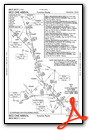
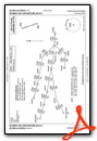
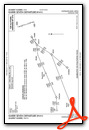
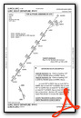
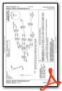
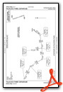
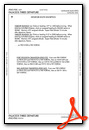
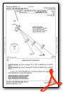
Standard Terminal Arrival (STAR) Charts

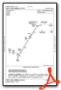
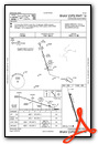
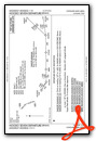
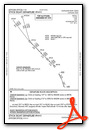
Instrument Approach Procedure (IAP) Charts
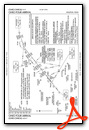
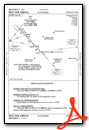
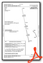
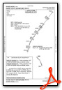
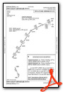
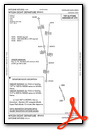
Departure Procedure (DP) Charts
Nearby Airports with Instrument Procedures
| ID | Name | Heading / Distance | ||
|---|---|---|---|---|
 |
00R | Livingston Municipal Airport | 358° | 19.7 |
|
KCXO | Conroe/North Houston Regional Airport | 269° | 21.1 |
|
T78 | Liberty Municipal Airport | 135° | 23.2 |
|
KIAH | George Bush Intcntl/Houston Airport | 217° | 28.2 |
|
KDWH | David Wayne Hooks Memorial Airport | 238° | 33.4 |
|
KHPY | Baytown Airport | 175° | 34.3 |
|
54T | Rwj Airpark Airport | 166° | 36.6 |
|
KUTS | Huntsville Municipal Airport | 308° | 38.0 |
|
45R | Hawthorne Field Airport | 091° | 39.0 |
|
T00 | Chambers County Airport | 152° | 39.4 |
|
T41 | La Porte Municipal Airport | 184° | 41.2 |
|
T90 | Chambers County/Winnie Stowell Airport | 136° | 44.0 |
Airport Images
Do you have a recent image of this airport? Upload it here!


Comments
This is one of the best FBOs in the USA
This is one of the best FBOs in the USA for you to visit with your single engine airplane.