Login
Register


TEB
Teterboro Airport
Official FAA Data Effective 2024-10-03 0901Z
From the Flight Deck
Chart Supplement

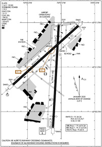
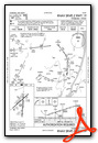
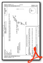
KTEB Airport Diagram
VFR Chart of KTEB
Sectional Charts at SkyVector.com
IFR Chart of KTEB
Enroute Charts at SkyVector.com
Location Information for KTEB
Coordinates: N40°51.01' / W74°3.65'Located 01 miles SW of Teterboro, New Jersey on 827 acres of land. View all Airports in New Jersey.
Surveyed Elevation is 8 feet MSL.
TPA 1500 FT MSL FOR LARGE/TURBINE ACFT; 1000 FT MSL FOR ALL OTHERS.
Operations Data
|
|
Airport Communications
| D-ATIS: | 114.2 (201-288-1690) 132.85 (201-288-1690) |
|---|---|
| ASOS: | Tel. 201-393-0855 |
| TETERBORO TOWER: | 119.5 125.1 |
| TETERBORO GROUND: | 121.9 |
| NEWARK APPROACH: | 127.6 379.9 |
| NEWARK DEPARTURE: | 119.2 126.7 379.9 |
| CLEARANCE DELIVERY: | 128.05 |
| OPS: | 130.575 |
| VFR ADZY: | 119.5 |
| MAZIE STAR: | 124.55 317.425 119.75 269.25 |
| WILKES-BARRE STAR: | 127.6 379.9 |
| RAMP CTL: | 120.675 |
| EMERG: | 121.5 243.0 |
| JAIKE STAR: | 124.35 319.15 |
| ASOS at LGA (9.2 SE): | 718-672-6317 |
| AWOS-3PT at JRB (9.2 S): | 128.175 212-425-1534 |
| D-ATIS at LGA (9.6 SE): | 127.05 ;DEP |
- FOR RADAR SVC BLO 1800 FT CTC TEB ATCT FREQ 119.5.
Nearby Navigation Aids
|
| ||||||||||||||||||||||||||||||||||||||||||||||||||||||||||||


Runway 01/19
| Dimensions: | 7000 x 150 feet / 2134 x 46 meters | |
|---|---|---|
| Surface: | Asphalt / Grooved in Good Condition | |
| Weight Limits: | 35 /F/C/X/T, S-50, D-100 | |
| Edge Lighting: | High Intensity | |
| Runway 01 | Runway 19 | |
| Coordinates: | N40°50.32' / W74°3.62' | N40°51.47' / W74°3.54' |
| Elevation: | 8.4 | 6.4 |
| Traffic Pattern: | Left | Left |
| Runway Heading: | 3° True | 183° True |
| Displaced Threshold: | 771 Feet | 763 Feet |
| Declared Distances: | TORA:7000 TODA:7000 ASDA:6932 LDA:6161 | TORA:7000 TODA:7000 ASDA:7000 LDA:6230 |
| Markings: | Precision Instrument in good condition. | Precision Instrument in good condition. |
| Glide Slope Indicator | P4L (3.10° Glide Path Angle) | P4L (3.00° Glide Path Angle) |
| REIL: | Yes | Yes |
| Centerline Lights: | Yes RWY 01/19 DTHR CNTRLN LGTS OTS INDEFLY. | Yes |
| Obstacles: | 88 ft Tree 802 ft from runway, 524 ft left of center RWY 01 67 FT TREE DIST 1200 FT, 400 FT RIGHT, 16:1 BASED ON DTHR. |
263 ft Building 9256 ft from runway, 319 ft left of center RWY 19 APCH RATIO 25:1 TO DTHR. |
Runway 06/24
| Dimensions: | 6013 x 150 feet / 1833 x 46 meters | |
|---|---|---|
| Surface: | Asphalt / Grooved in Good Condition | |
| Weight Limits: | 35 /F/C/X/T, S-50, D-100 | |
| Edge Lighting: | High Intensity | |
| Runway 06 | Runway 24 | |
| Coordinates: | N40°50.80' / W74°4.22' | N40°51.46' / W74°3.25' |
| Elevation: | 4.9 | 6.8 |
| Traffic Pattern: | Left | Left |
| Runway Heading: | 48° True | 228° True |
| Declared Distances: | TORA:6013 TODA:6013 ASDA:6013 LDA:6013 | TORA:6013 TODA:6013 ASDA:6013 LDA:6013 |
| Markings: | Precision Instrument in good condition. | Precision Instrument in good condition. |
| Glide Slope Indicator | P4L (3.20° Glide Path Angle) | |
| RVR Equipment | Touchdown Rollout | Touchdown Rollout |
| Approach Lights: | MALSR 1,400 Foot Medium-intensity Approach Lighting System with runway alignment indicator lights. | |
| REIL: | Yes | Yes |
| Centerline Lights: | Yes | Yes |
| Obstacles: | 148 ft Tree 5950 ft from runway, 1293 ft left of center | 77 ft Tree 1705 ft from runway, 462 ft left of center |
Services Available
| Fuel: | 100LL (blue), Jet-A |
|---|---|
| Transient Storage: | Hangars,Tiedowns |
| Airframe Repair: | MAJOR |
| Engine Repair: | MAJOR |
| Bottled Oxygen: | HIGH/LOW |
| Bulk Oxygen: | HIGH/LOW |
| Other Services: | AVIONICS,CARGO HANDLING SERVICES,CHARTER SERVICE,AIRCRAFT SALES |
Ownership Information
| Ownership: | Publicly owned | |
|---|---|---|
| Owner: | PORT AUTHORITY OF NY & NJ | |
| 4 WORLD TRADE CENTER | ||
| NEW YORK, NY 10006 | ||
| 212-435-3640 | ||
| Manager: | MARIA SHERIDAN | |
| 90 MOONACHIE AVE | ||
| TETERBORO, NJ 07608 | ||
| 201-288-1775 | ||
Other Remarks
- CLSD TO MOTORLESS ACFT - UNCTLD ACFT & ULTRALIGHT ACTIVITY EXCEP BY PRIOR PERMISSION.
- DLY CONS CONST ACT ALL QUADRANTS.
- ACFT CAPABLE OF OPERATING ABV 100,000 POUNDS MUST SUBMIT CERTIFICATION TO AMGR VERIFYING AIRCRAFT OPERATING WEIGHT IS LESS THAN 100,000 LBS. CONTACT AIRPORT OPERATIONS AT 201-288-1775 FOR FORMS.
- TEB RNAV (GPS) X RWY 06 IS PRIM RNAV APCH TO RWY 06.
- ALL ACFT AVOID HOSPITAL 1.7 MILE NORTH OF RWY 01/19.
- DEER AND BIRD ACT ON AND INVOF ARPT.
- HEL OPNS OVER RESIDENTIAL AREAS BLO 1000 FT MSL SHOULD BE AVOIDED.
- ACFT & HELICOPTER NOISE ABATEMENT RULES IN EFF; CTC ARPT NOISE ABATEMENT OFC 201-393-0399/288-1775 FOR COPY OF PROCEDURES & RULES PRIOR TO ARR. RY 24 NOISE CRITICAL RY MAX NOISE LIMIT OF 80 DB BETWEEN 2200-0700 & 90 DB ALL OTR HRS.
- STAGE 1 ACFT NOT PERMITTED TO OPR AT TETERBORO ARPT.
- ARPT OPS FREQUENCY 130.575.
- TPA 1500 FT MSL FOR LARGE/TURBINE ACFT; 1000 FT MSL FOR ALL OTHERS.
- EMAS NON-STD ARRESTING GEAR/SYSTEM: ENGINEERED MATERIALS ARRESTING SYSTEM (EMAS) 250 FT IN LENGTH BY 170 FT WIDTH LCTD AT DEP END RWY 06.
- ENGINEERED MATERIALS ARRESTING SYSTEM (EMAS) 355 FT IN LENGTH BY 162 FT WIDTH LCTD AT DEP END RWY 19.
- ENGINEERED MATERIALS ARRESTING SYSTEM (EMAS) 348 FT IN LENGTH BY 162 FT WIDTH LCTD AT DEP END RWY 24.
Weather Minimums


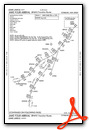
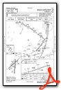
Standard Terminal Arrival (STAR) Charts

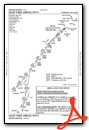
Instrument Approach Procedure (IAP) Charts


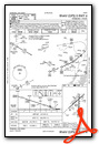

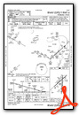


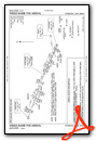
Departure Procedure (DP) Charts


Nearby Airports with Instrument Procedures
| ID | Name | Heading / Distance | ||
|---|---|---|---|---|
 |
KJRA | West 30th St Heliport | 157° | 6.2 |
 |
KLGA | Laguardia Airport | 116° | 9.6 |
|
KCDW | Essex County Airport | 278° | 10.2 |
|
KEWR | Newark Liberty International Airport | 207° | 10.7 |
|
N07 | Lincoln Park Airport | 296° | 12.9 |
|
KLDJ | Linden Airport | 211° | 16.3 |
|
KMMU | Morristown Municipal Airport | 259° | 16.4 |
|
KJFK | John F Kennedy International Airport | 134° | 18.0 |
|
KHPN | Westchester County Airport | 050° | 20.7 |
|
4N1 | Greenwood Lake Airport | 322° | 21.1 |
|
KFRG | Republic Airport | 103° | 30.4 |
|
KSMQ | Somerset Airport | 244° | 30.9 |
Fuel Providers

Airport Images
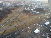
By: BarryChung


Comments
Can someone post the "special
Can someone post the "special notices" brief for visual arrivals and noise sensitive areas? There used to be a chart in Jepp for this for the circle to land procs, but they don't seem to publish this anymore. Thanks.