Login
Register


MAL
Malone-Dufort Airport
Official FAA Data Effective 2024-11-28 0901Z
Chart Supplement

VFR Chart of KMAL
Sectional Charts at SkyVector.com
IFR Chart of KMAL
Enroute Charts at SkyVector.com
Location Information for KMAL
Coordinates: N44°51.22' / W74°19.74'Located 02 miles W of Malone, New York on 135 acres of land. View all Airports in New York.
Surveyed Elevation is 789 feet MSL.
Operations Data
|
|
Airport Communications
| AWOS-AV: | 122.8 Tel. (518) 651-2601 |
|---|---|
| CTAF: | 122.800 |
| UNICOM: | 122.800 |
| ASOS at MSS (22.6 W): | 128.075 315-764-0481 |
| ASOS at SLK (28.2 S): | 124.175 518-891-6696 |
| AWOS-3P at PTD (28.4 W): | 118.325 315-265-6106 |
- APCH/DEP SVC PRVDD BY BOSTON ARTCC ON FREQS 135.25/377.1 (TURIN RCAG).
Nearby Navigation Aids
|
| ||||||||||||||||||||||||||||||||||||||||||||||||||||||||||||


Runway 05/23
| Dimensions: | 3994 x 100 feet / 1217 x 30 meters | |
|---|---|---|
| Surface: | Asphalt in Excellent Condition | |
| Weight Limits: | S-20 | |
| Edge Lighting: | Medium Intensity | |
| Runway 05 | Runway 23 | |
| Coordinates: | N44°50.97' / W74°20.18' | N44°51.49' / W74°19.62' |
| Elevation: | 770.7 | 754.4 |
| Traffic Pattern: | Left | Left |
| Runway Heading: | 37° True | 217° True |
| Declared Distances: | TORA:3994 TODA:3994 ASDA:3994 LDA:3994 | TORA:3994 TODA:3994 ASDA:3994 LDA:3994 |
| Markings: | Non-Precision Instrument in good condition. | Non-Precision Instrument in good condition. |
| Glide Slope Indicator | P2L (3.15° Glide Path Angle) | P2L (3.00° Glide Path Angle) |
| REIL: | Yes | Yes |
| Obstacles: | 36 ft Trees 392 ft from runway, 255 ft left of center | 20 ft Trees 671 ft from runway, 285 ft right of center |
Runway 14/32
| Dimensions: | 3250 x 75 feet / 991 x 23 meters | |
|---|---|---|
| Surface: | Asphalt in Good Condition | |
| Weight Limits: | S-12 | |
| Edge Lighting: | Medium Intensity | |
| Runway 14 | Runway 32 | |
| Coordinates: | N44°51.37' / W74°19.84' | N44°51.04' / W74°19.24' |
| Elevation: | 759.5 | 789.9 |
| Runway Heading: | 127° True | 307° True |
| Displaced Threshold: | 348 Feet | |
| Declared Distances: | TORA:3250 TODA:3250 ASDA:3250 LDA:3250 | TORA:3250 TODA:3250 ASDA:3250 LDA:2902 |
| Markings: | Basic in good condition. | Basic in fair condition. |
| Obstacles: | 30 ft Trees 815 ft from runway, 144 ft left of center +5 FT CROPS 67 FT FROM THLD, 107 FT RIGHT. |
18 ft Tree 200 ft from runway, 81 ft right of center APCH SLOPE 21:1, DUE TO +72 FT BLDG, 1572 FT FM DSPLCD THLD; +38 FT TREES, 805 FT FM DSPLCD THLD. +18 FT ROAD WITH TALL FARM EQUIPMENT, 27 FT FM RWY, ACROSS CNTRLN. |
Services Available
| Fuel: | 100LL (blue) |
|---|---|
| Transient Storage: | Tiedowns |
| Airframe Repair: | NONE |
| Engine Repair: | NONE |
| Bottled Oxygen: | NONE |
| Bulk Oxygen: | NONE |
Ownership Information
| Ownership: | Publicly owned | |
|---|---|---|
| Owner: | TOWN OF MALONE | |
| 27 AIRPORT ROAD | ||
| MALONE, NY 12953 | ||
| (518) 483-4740 | ||
| Manager: | BRUCE BURDITT | |
| 27 AIRPORT ROAD | ||
| MALONE, NY 12953 | ||
| (518) 483-4740 | ||
Other Remarks
- HAYING ACTIVITY & EQUIPMENT PRESENT JUN - SEP.
- RY 14/32 HAS SNOW REMOVAL BUT VISUAL INSPECTION & NOTAM CHECK MUST BE DONE AS TOWN ROADS ARE PLOWED BEFORE ARPT.
- FOR CD CTC BOSTON ARTCC AT 603-879-6859.
- AIRPORT NOT ATTENDED
- ACTVT PAPI RWY 05 & 23, MIRL RWY 05/23, 14/32 & TWY LGTS - CTAF.
Weather Minimums
Instrument Approach Procedure (IAP) Charts
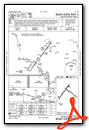
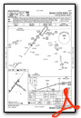
Nearby Airports with Instrument Procedures
| ID | Name | Heading / Distance | ||
|---|---|---|---|---|
 |
KMSS | Massena International-Richards Field Airport | 282° | 22.6 |
|
KPTD | Potsdam Municipal/Damon Field Airport | 248° | 28.5 |
|
KSLK | Adirondack Regional Airport | 169° | 28.6 |
|
KPBG | Plattsburgh International Airport | 107° | 38.8 |
|
KLKP | Lake Placid Airport | 155° | 38.7 |
|
KOGS | Ogdensburg International Airport | 258° | 49.6 |
|
CYJN | St Jean Airport | 058° | 51.8 |
|
KFSO | Franklin County State Airport | 083° | 52.8 |
|
KBTV | Patrick Leahy Burlington International Airport | 114° | 55.3 |
|
CYOW | Ottawa/Macdonald-Cartier International Airport | 296° | 63.5 |
|
CYND | Ottawa/Gatineau Airport | 307° | 66.0 |
|
4B6 | Ticonderoga Municipal Airport | 145° | 70.6 |
Airport Images
Do you have a recent image of this airport? Upload it here!


Comments
fuel
<p>we now have fuel 100LL</p>