Login
Register
JHW
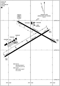
Chautauqua County/Jamestown Airport
Official FAA Data Effective 2024-12-26 0901Z
VFR Chart of KJHW
Sectional Charts at SkyVector.com
IFR Chart of KJHW
Enroute Charts at SkyVector.com
Location Information for KJHW
Coordinates: N42°9.20' / W79°15.48'Located 03 miles N of Jamestown, New York on 788 acres of land. View all Airports in New York.
Surveyed Elevation is 1723 feet MSL.
Operations Data
|
|
Airport Communications
| AWOS-3PT: | 118.425 Tel. 716-664-6005 |
|---|---|
| BUFFALO APPROACH: | 126.05 |
| BUFFALO DEPARTURE: | 126.05 |
| UNICOM: | 122.975 |
| CTAF: | 122.975 |
| ASOS at DKK (20.4 N): | 119.275 716-366-7664 |
| AWOS-3P at XNT (34.1 NE): | 122.8 716-592-4400 |
| ASOS at BFD (34.7 SE): | 133.825 814-368-2581 |
- APCH/DEP SVC PRVDD BY BUFFALO APCH (BUF) ON 126.05 0600-0000. APCH/DEP SVC PRVDD BY CLEVELAND ARTCC (ZOB) ON FREQ 127.075/292.175 (WATERFORD RCAG) 0000-0600.
Nearby Navigation Aids
|
| ||||||||||||||||||||||||||||||||||||||||||||||||||||||||||||
Runway 07/25
| Dimensions: | 5300 x 100 feet / 1615 x 30 meters | |
|---|---|---|
| Surface: | Asphalt / Grooved in Excellent Condition | |
| Weight Limits: | S-57, D-95, ST-125
PCR VALUE: 250/F/B/W/T
| |
| Edge Lighting: | High Intensity | |
| Runway 07 | Runway 25 | |
| Coordinates: | N42°8.89' / W79°16.09' | N42°9.34' / W79°15.08' |
| Elevation: | 1720.6 | 1718.6 |
| Traffic Pattern: | Left | Left |
| Runway Heading: | 59° True | 239° True |
| Declared Distances: | TORA:5300 TODA:5300 ASDA:5300 LDA:5300 | TORA:5300 TODA:5300 ASDA:5300 LDA:5300 |
| Markings: | Non-Precision Instrument in good condition. | Precision Instrument in good condition. |
| Glide Slope Indicator | V4L (3.00° Glide Path Angle) | |
| Approach Lights: | MALSR 1,400 Foot Medium-intensity Approach Lighting System with runway alignment indicator lights. | |
Runway 13/31
| Dimensions: | 4499 x 100 feet / 1371 x 30 meters | |
|---|---|---|
| Surface: | Asphalt in Fair Condition | |
| Weight Limits: | S-31, D-56
PCR VALUE: 148/F/C/W/T
| |
| Edge Lighting: | Medium Intensity | |
| Runway 13 | Runway 31 | |
| Coordinates: | N42°9.49' / W79°15.80' | N42°9.13' / W79°14.92' |
| Elevation: | 1723.3 | 1707.2 |
| Traffic Pattern: | Left | Left |
| Runway Heading: | 119° True | 299° True |
| Declared Distances: | TORA:4499 TODA:4499 ASDA:4499 LDA:4499 | TORA:4499 TODA:4499 ASDA:4499 LDA:4499 |
| Markings: | Non-Precision Instrument in good condition. | Non-Precision Instrument in good condition. |
| Glide Slope Indicator | P4L (3.00° Glide Path Angle) | P4L (3.00° Glide Path Angle) |
| REIL: | Yes | |
| Obstacles: | 69 ft Tree 1400 ft from runway, 240 ft left of center | 61 ft Building 1200 ft from runway, 300 ft left of center |
Services Available
| Fuel: | 100LL (blue), Jet-A |
|---|---|
| Transient Storage: | Hangars,Tiedowns |
| Airframe Repair: | MAJOR |
| Engine Repair: | MAJOR |
| Bottled Oxygen: | NONE |
| Bulk Oxygen: | HIGH/LOW |
| Other Services: | AIR FREIGHT SERVICES,PILOT INSTRUCTION,AIRCRAFT RENTAL,AIRCRAFT SALES |
Ownership Information
| Ownership: | Publicly owned | |
|---|---|---|
| Owner: | CHAUTAUQUA COUNTY | |
| NORTH ERIE ST., COUNTY OFFICE BLDGS | ||
| MAYVILLE, NY 14757 | ||
| 716-753-4000 | ||
| Manager: | SHANNON FISCHER | |
| 3163 AIRPORT DR | ||
| JAMESTOWN, NY 14701 | ||
| 716-484-0204 | ||
Other Remarks
- DEER AND BIRDS ON & INVOF ARPT.
- SNOW REMOVAL OPS AVBL DURING NORMAL ATTENDANCE HRS; SNOW REMOVAL MAY BE LIMITED ON HOLIDAYS & WEEKENDS.
- FOR CD CTC BUFFALO APCH AT 716-626-6920, WHEN APCH CLSD CTC CLEVELAND ARTCC AT 440-774-0232.
- ATTENDANCE HRS AND SERVICES AVAILABLE ARE SUBJECT TO CHANGE, CALL AIRPORT MANAGER AT 716-484-0204 TO CONFIRM.
- RWY/TWY CONDITIONS NOT MONITORED OUTSIDE OF NORMAL ATTENDANCE HRS.
- 24 HR PPR FOR AIR CARRIER OPS WITH MORE THAN 9 PAX SEATS. CONTACT ARPT MGR AT 716-484-0204. FOR EMERGENCIES AFTER HRS, CALL 911 FOR MUTUAL AID SERVICE.
- ARFF INDEX B CPBL.
- ACTVT MALSR RWY 25; REIL RWY 31; PAPI RWY 13 & 31; VASI RWY 07; HIRL RWY 07/25; MIRL RWY 13/31 & TWY LGTS - CTAF.
Weather Minimums
Instrument Approach Procedure (IAP) Charts
Nearby Airports with Instrument Procedures
| ID | Name | Heading / Distance | ||
|---|---|---|---|---|
 |
KDKK | Chautauqua County/Dunkirk Airport | 358° | 20.4 |
 |
8G2 | Corry-Lawrence Airport | 229° | 22.6 |
 |
KBFD | Bradford Regional Airport | 127° | 34.7 |
 |
6G1 | Titusville Airport | 213° | 39.2 |
 |
KOLE | Cattaraugus County-Olean Airport | 082° | 39.9 |
 |
KERI | Erie International/Tom Ridge Field Airport | 264° | 41.1 |
 |
9G0 | Buffalo Airfield Airport | 029° | 48.8 |
 |
KBUF | Buffalo Niagara International Airport | 026° | 52.7 |
 |
KGKJ | Port Meadville Airport | 233° | 53.3 |
 |
KFKL | Venango Regional Airport | 210° | 53.8 |
 |
KBQR | Buffalo-Lancaster Regional Airport | 031° | 54.3 |
 |
KOYM | St Marys Municipal Airport | 142° | 55.9 |


