Login
Register
TIW
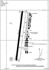
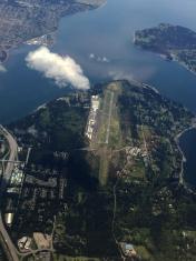
Tacoma Narrows Airport
Official FAA Data Effective 2024-11-28 0901Z
VFR Chart of KTIW
Sectional Charts at SkyVector.com
IFR Chart of KTIW
Enroute Charts at SkyVector.com
Location Information for KTIW
Coordinates: N47°16.08' / W122°34.69'Located 04 miles W of Tacoma, Washington on 644 acres of land. View all Airports in Washington.
Surveyed Elevation is 294 feet MSL.
Operations Data
|
|
Airport Communications
| ATIS: | 124.05 |
|---|---|
| ASOS: | Tel. 253-858-6507 |
| TACOMA TOWER: | 118.5 253.5 |
| TACOMA GROUND: | 121.8 |
| SEATTLE APPROACH: | 120.1 290.9 |
| SEATTLE DEPARTURE: | 120.1 290.9 |
| UNICOM: | 122.950 |
| CTAF: | 118.500 |
| D-ATIS at TCM (8.9 SE): | 270.1 |
| ASOS at TCM (8.9 SE): | 253-982-3434 |
| ATIS at GRF (11.3 S): | 124.65 |
- FREQ 121.5 NOT AVBL.
Nearby Navigation Aids
|
| ||||||||||||||||||||||||||||||||||||||||||||||||
Runway 17/35
| Dimensions: | 5002 x 100 feet / 1525 x 30 meters | |
|---|---|---|
| Surface: | Asphalt / Grooved in Good Condition | |
| Weight Limits: | S-50, D-80, ST-80, DT-150 | |
| Edge Lighting: | Medium Intensity | |
| Runway 17 | Runway 35 | |
| Coordinates: | N47°16.48' / W122°34.61' | N47°15.67' / W122°34.76' |
| Elevation: | 291.8 | 294.7 |
| Traffic Pattern: | Left | Right |
| Runway Heading: | 187° True | 7° True |
| Markings: | Precision Instrument in good condition. | Non-Precision Instrument in good condition. |
| Glide Slope Indicator | P4R (3.00° Glide Path Angle) | P4L (3.00° Glide Path Angle) PAPI UNUSBL BYD 5.0 DEGREES LEFT OF CNTRLN. |
| Approach Lights: | MALSR 1,400 Foot Medium-intensity Approach Lighting System with runway alignment indicator lights. | |
| REIL: | Yes | |
Services Available
| Fuel: | 100LL (blue), Jet-A |
|---|---|
| Transient Storage: | Hangars,Tiedowns PILOTS BRING OWN TIEDOWNS. |
| Airframe Repair: | MAJOR |
| Engine Repair: | MAJOR |
| Bottled Oxygen: | LOW |
| Bulk Oxygen: | NONE |
| Other Services: | AVIONICS,CHARTER SERVICE,PILOT INSTRUCTION,AIRCRAFT RENTAL,AIRCRAFT SALES |
Ownership Information
| Ownership: | Publicly owned | |
|---|---|---|
| Owner: | PIERCE COUNTY PUB WORKS & UTILITIES | |
| 9850 - 64TH ST. W. | ||
| UNIVERSITY PLACE, WA 98467-7322 | ||
| 253-798-2421 | ||
| Manager: | ROD PROPST | |
| 1202 - 26TH AVE. N.W. | ||
| GIG HARBOR, WA 98335-7322 | ||
| 253-798-8550 | ||
Other Remarks
- NOISE SENSITIVE ARPT; FOR NOISE ABATEMENT & TFC PROCEDURES CALL AIRPORT OFFICE 253-798-8550.
- DEER ON & INVOF ARPT.
- (E94) LAWRS OPERS DURING TWR OPNS ONLY.
- EMERG FREQ 121.5 NOT MNT AT TWR.
- FOR CD WHEN ATCT IS CLSD CTC SEATTLE APCH AT 206-214-4723.
- WHEN ATCT CLSD, ACTVT MALSR RWY 17; REIL RWY 35; PAPI RWY 17 & 35; MIRL 17/35 - CTAF.
Weather Minimums
Instrument Approach Procedure (IAP) Charts
Departure Procedure (DP) Charts
Nearby Airports with Instrument Procedures
| ID | Name | Heading / Distance | ||
|---|---|---|---|---|
 |
KTCM | Mcchord Field (Joint Base Lewis-Mcchord) Airport | 151° | 8.9 |
 |
KGRF | Gray AAF (Joint Base Lewis-Mcchord) Airport | 180° | 11.3 |
 |
S50 | Auburn Municipal Airport | 075° | 14.8 |
 |
KPWT | Bremerton Ntl Airport | 330° | 15.4 |
 |
KSEA | Seattle-Tacoma International Airport | 044° | 15.4 |
 |
KPLU | Pierce County/Thun Field Airport | 129° | 15.4 |
 |
KBFI | Boeing Field/King County International Airport | 035° | 19.3 |
 |
KRNT | Renton Municipal Airport | 047° | 20.0 |
 |
KOLM | Olympia Regional Airport | 216° | 22.3 |
 |
KSHN | Sanderson Field Airport | 265° | 23.4 |
 |
KCLS | Chehalis-Centralia Airport | 205° | 39.2 |
 |
KPAE | Seattle Paine Field International Airport | 017° | 40.2 |


