Login
Register
HGR
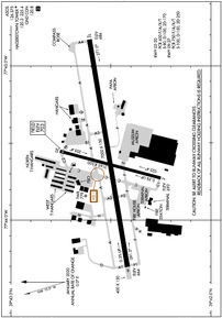
Hagerstown Regional/Richard A Henson Field Airport
Official FAA Data Effective 2024-12-26 0901Z
VFR Chart of KHGR
Sectional Charts at SkyVector.com
IFR Chart of KHGR
Enroute Charts at SkyVector.com
Location Information for KHGR
Coordinates: N39°42.51' / W77°43.59'Located 04 miles N of Hagerstown, Maryland on 693 acres of land. View all Airports in Maryland.
Surveyed Elevation is 703 feet MSL.
Operations Data
|
|
Airport Communications
| ASOS: | 126.375 Tel. 301-745-3497 |
|---|---|
| HAGERSTOWN TOWER: | 120.3 225.4 |
| HAGERSTOWN GROUND: | 120.8 |
| POTOMAC APPROACH: | 126.825 239.025 |
| POTOMAC DEPARTURE: | 126.825 239.025 |
| TRSTN STAR: | 126.75 307.2 |
| UNICOM: | 122.950 |
| AR OPS: | 32.3FM |
| EMERG: | 121.5 243.0 |
| CTAF: | 120.300 |
| AWOS-3 at N68 (16.4 N): | 120.725 717-261-1943 |
| ASOS at MRB (21.6 SW): | 119.925 304-264-0988 |
| ATIS at FDK (23.9 SE): | 124.875 |
Nearby Navigation Aids
|
| ||||||||||||||||||||||||||||||||||||||||||||||||||||||||||||
Runway 09/27
| Dimensions: | 7000 x 150 feet / 2134 x 46 meters | |
|---|---|---|
| Surface: | Asphalt / Grooved in Good Condition | |
| Weight Limits: | S-100, D-150, ST-250
PCR VALUE: 750/F/A/X/T
| |
| Edge Lighting: | High Intensity | |
| Runway 09 | Runway 27 | |
| Coordinates: | N39°42.42' / W77°44.30' | N39°42.61' / W77°42.83' |
| Elevation: | 664.4 | 685.5 |
| Traffic Pattern: | Left | Left |
| Runway Heading: | 81° True | 261° True |
| Declared Distances: | TORA:7000 TODA:7000 ASDA:7000 LDA:7000 | TORA:7000 TODA:7000 ASDA:7000 LDA:7000 |
| Markings: | Precision Instrument in good condition. | Precision Instrument in good condition. |
| Glide Slope Indicator | P4L (3.00° Glide Path Angle) | P4L (3.00° Glide Path Angle) |
| Approach Lights: | MALSR 1,400 Foot Medium-intensity Approach Lighting System with runway alignment indicator lights. | |
| REIL: | Yes | |
Runway 02/20
| Dimensions: | 3165 x 100 feet / 965 x 30 meters | |
|---|---|---|
| Surface: | Asphalt in Good Condition | |
| Weight Limits: | S-80, D-100, ST-170
PCR VALUE: 600/F/A/X/T
| |
| Edge Lighting: | Medium Intensity | |
| Runway 02 | Runway 20 | |
| Coordinates: | N39°42.25' / W77°43.73' | N39°42.76' / W77°43.55' |
| Elevation: | 692.0 | 702.9 |
| Traffic Pattern: | Left | Left |
| Runway Heading: | 15° True | 195° True |
| Declared Distances: | TORA:3165 TODA:3165 ASDA:3165 LDA:3165 | TORA:3165 TODA:3165 ASDA:3165 LDA:3165 |
| Markings: | Basic in good condition. | Basic in good condition. |
| Glide Slope Indicator | P2L (4.00° Glide Path Angle) | P2L (4.00° Glide Path Angle) |
| REIL: | Yes | Yes |
Services Available
| Fuel: | 100LL (blue), Jet-A |
|---|---|
| Transient Storage: | Hangars,Tiedowns |
| Airframe Repair: | MAJOR |
| Engine Repair: | MAJOR |
| Bottled Oxygen: | HIGH/LOW |
| Bulk Oxygen: | HIGH/LOW |
| Other Services: | AIR FREIGHT SERVICES,AIR AMBULANCE SERVICES,AVIONICS,CARGO HANDLING SERVICES,CHARTER SERVICE,PILOT INSTRUCTION,ANNUAL SURVEYING |
Ownership Information
| Ownership: | Publicly owned | |
|---|---|---|
| Owner: | WASHINGTON COUNTY | |
| 100 WEST WASHINGTON ST | ||
| HAGERSTOWN, MD 21740 | ||
| 240-313-2200 | ||
| Manager: | NEIL DORAN | |
| 18434 SHOWALTER RD | ||
| HAGERSTOWN, MD 21742 | ||
| 240-313-2764 | ||
Other Remarks
- RWY 02 & 20 CLSD WHEN ATCT CLSD.
- FOR CD WHEN ATCT IS CLSD CTC POTOMAC APCH AT 866-709-4993.
- RWY 02/20 CLSD TO SKED ACR OPS WITH MORE THAN 9 PAX SEATS AND NON SKED ACR OPS WITH MORE THAN 30 PAX SEATS EXCP FOR TAXI.
- BIRDS ON & INVOF ARPT.
- LOW LEVEL MIL ACFT 10 NM NORTH ON VR708 OPERATING EAST TO WEST.
- ULTRALIGHT ACT 12 NM EAST TO 5000 FT MSL.
- TWY "P" NOT AVBL FOR AIR CARRIER OPS.
- PPR 24 HRS FOR UNSKED ACR OPNS WITH MORE THAN 30 PSGR SEATS CALL AMGR 240-313-2764.
- 0LL FUEL AVBL 0500-2200 CALL 301-791-9119. DOD CONTRACT FUEL AVBL.
- WHEN ATCT CLSD ACTVT MALSR RWY 27; REIL RWY 09; HIRL RWY 09/27 - CTAF.
Weather Minimums
Standard Terminal Arrival (STAR) Charts
Instrument Approach Procedure (IAP) Charts
Nearby Airports with Instrument Procedures
| ID | Name | Heading / Distance | ||
|---|---|---|---|---|
 |
N68 | Franklin County Regional Airport | 013° | 16.3 |
 |
W35 | Potomac Airpark Airport | 267° | 20.4 |
 |
KMRB | Eastern Wv Regional/Shepherd Field Airport | 213° | 21.9 |
 |
W05 | Gettysburg Regional Airport | 069° | 22.4 |
 |
KFDK | Frederick Municipal Airport | 136° | 23.9 |
 |
KDMW | Carroll County Regional/Jack B Poage Field Airport | 099° | 33.8 |
 |
2W2 | Clearview Airpark Airport | 113° | 35.9 |
 |
N94 | Carlisle Airport | 041° | 38.4 |
 |
W50 | Davis Airport | 136° | 38.6 |
 |
KJYO | Leesburg Exec Airport | 168° | 38.6 |
 |
KOKV | Winchester Regional Airport | 209° | 39.0 |
 |
KTHV | York Airport | 072° | 41.4 |


Comments
KHGR
Pages