Login
Register
MDH
Southern Illinois Airport
Official FAA Data Effective 2024-12-26 0901Z
From the Flight Deck
VFR Chart of KMDH
Sectional Charts at SkyVector.com
IFR Chart of KMDH
Enroute Charts at SkyVector.com
Location Information for KMDH
Coordinates: N37°46.68' / W89°15.12'Located 03 miles NW of Carbondale/Murphysboro, Illinois on 1200 acres of land. View all Airports in Illinois.
Surveyed Elevation is 411 feet MSL.
Operations Data
|
|
Airport Communications
| ATIS: | 119.725 |
|---|---|
| ASOS: | Tel. 618-529-1821 |
| SOUTHERN TOWER: | 125.35 126.25 322.4 |
| SOUTHERN GROUND: | 121.8 |
| CTAF: | 125.350 |
| UNICOM: | 122.950 |
| AWOS-3P at MWA (11.5 E): | 119.675 618-942-8877 |
| AWOS-3PT at PCD (29.4 W): | 118.95 573-543-5390 |
| AWOS-3PT at SAR (30.7 NW): | 118.375 618-443-3296 |
- APCH/DEP SVC PRVDD BY KANSAS CITY ARTCC ON FREQS 127.475/346.275 (MARION RCAG).
Nearby Navigation Aids
|
| ||||||||||||||||||||||||||||||||||||||||||||||||||||||||||||
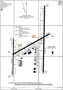
Runway 18L/36R
| Dimensions: | 6506 x 100 feet / 1983 x 30 meters | |
|---|---|---|
| Surface: | Asphalt / Grooved in Excellent Condition | |
| Edge Lighting: | High Intensity | |
| Runway 18L | Runway 36R | |
| Coordinates: | N37°47.31' / W89°14.88' | N37°46.24' / W89°14.90' |
| Elevation: | 404.1 | 397.2 |
| Traffic Pattern: | Left | Left |
| Runway Heading: | 181° True | 1° True |
| Declared Distances: | TORA:6506 TODA:6506 ASDA:6506 LDA:6506 | TORA:6506 TODA:6506 ASDA:6506 LDA:6506 |
| Markings: | Precision Instrument in good condition. | Non-Precision Instrument in good condition. |
| Glide Slope Indicator | P4L (3.00° Glide Path Angle) | |
| Approach Lights: | MALSR 1,400 Foot Medium-intensity Approach Lighting System with runway alignment indicator lights. | |
| REIL: | Yes | |
Runway 06/24
RWY 06/24 NOT AVBL FOR UNSCHEDULED ACR AT LEAST 31 PSGR SEATS. | ||
| Dimensions: | 4163 x 100 feet / 1269 x 30 meters | |
|---|---|---|
| Surface: | Asphalt / Porous Friction Course in Fair Condition | |
| Weight Limits: | S-86, D-110, ST-167
RSTRD TO ACFT 12500 LBS OR LESS UNLESS PPR WITH ATCT.
PCR VALUE: 350/F/D/X/T
| |
| Edge Lighting: | Medium Intensity | |
| Runway 06 | Runway 24 | |
| Coordinates: | N37°46.53' / W89°15.53' | N37°46.87' / W89°14.77' |
| Elevation: | 410.9 | 405.0 |
| Traffic Pattern: | Left | Left |
| Runway Heading: | 61° True | 241° True |
| Declared Distances: | TORA:4163 TODA:4163 ASDA:4163 LDA:4163 | TORA:4163 TODA:4163 ASDA:4163 LDA:4163 |
| Markings: | Basic in good condition. | Basic in good condition. |
| Glide Slope Indicator | V4L (3.50° Glide Path Angle) | P4R (3.50° Glide Path Angle) |
| REIL: | Yes | Yes |
Runway 18R/36L
RWY 18R/36L NOT AVBL FOR UNSCHEDULED ACR AT LEAST 31 PSGR SEATS. | ||
| Dimensions: | 3498 x 60 feet / 1066 x 18 meters | |
|---|---|---|
| Surface: | Asphalt in Excellent Condition | |
| Edge Lighting: | Medium Intensity | |
| Runway 18R | Runway 36L | |
| Coordinates: | N37°46.78' / W89°15.51' | N37°46.21' / W89°15.52' |
| Elevation: | 404.8 | 409.9 |
| Runway Heading: | 181° True | 1° True |
| Declared Distances: | TORA:3498 TODA:3498 ASDA:3498 LDA:3498 | TORA:3498 TODA:3498 ASDA:3498 LDA:3498 |
| Markings: | Basic in good condition. | Basic in good condition. |
| Glide Slope Indicator | PSIL (3.00° Glide Path Angle) UNUSBL BYD 6 DEG RIGHT OF COURSE. PVASI OTS INDEF. | PSIL (3.00° Glide Path Angle) |
Services Available
| Fuel: | 100LL (blue), Jet-A |
|---|---|
| Transient Storage: | Hangars,Tiedowns |
| Airframe Repair: | MAJOR |
| Engine Repair: | MAJOR |
| Bottled Oxygen: | NONE |
| Bulk Oxygen: | NONE |
| Other Services: | AIR AMBULANCE SERVICES,CARGO HANDLING SERVICES,CHARTER SERVICE,PILOT INSTRUCTION,AIRCRAFT RENTAL,AIRCRAFT SALES |
Ownership Information
| Ownership: | Publicly owned | |
|---|---|---|
| Owner: | SOUTHERN ILLINOIS ARPT AUTH | |
| PO BOX 1086 | ||
| CARBONDALE, IL 62903 | ||
| 618-529-1721 | ||
| Manager: | GARY R. SHAFER | |
| P O BOX 1086 | ||
| CARBONDALE, IL 62903 | ||
| 618-529-1721 | ||
Other Remarks
- BIRDS ON & INVOF ARPT.
- HIGH STUDENT TRNG ACTVTY.
- RWY 6 & RWY 18R-36L INTERSECT; VERIFY CORRECT COMPASS HDG FOR RWY 6 DEP.
- ACTVT MALSR RWY 18L; VASI RWY 06; PAPI RWY 24 & 36R; MIRL RWY 06/24; HIRL RWY 18L/36R - CTAF. WHEN ATCT CLSD HIRL RWY 18L/36R PRESET MED INTST; INCREASE INTST - CTAF. WHEN ATCT CLSD 18R/36L LTG BY REQUEST ONLY - CALL 618-534-3662.
Weather Minimums
Instrument Approach Procedure (IAP) Charts
Nearby Airports with Instrument Procedures
| ID | Name | Heading / Distance | ||
|---|---|---|---|---|
 |
KMWA | Veterans Airport of Southern Illinois Airport | 096° | 11.5 |
 |
KPJY | Pinckneyville/Du Quoin Airport | 336° | 13.0 |
 |
H96 | Benton Municipal Airport | 047° | 20.5 |
 |
KPCD | Perryville Regional Airport | 280° | 29.5 |
 |
KSAR | Sparta Community-Hunter Field Airport | 316° | 30.7 |
 |
KHSB | Harrisburg-Raleigh Airport | 086° | 33.4 |
 |
KCGI | Cape Girardeau Regional Airport | 204° | 36.5 |
 |
KMVN | Mount Vernon Airport | 029° | 37.6 |
 |
KCIR | Cairo Regional Airport | 177° | 42.8 |
 |
KENL | Centralia Municipal Airport | 009° | 44.8 |
 |
KPAH | Barkley Regional Airport | 151° | 48.7 |
 |
H88 | A Paul Vance Fredericktown Regional Airport | 258° | 50.4 |


