Login
Register
OCH
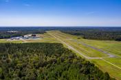
Nacogdoches A L Mangham Jr Regional Airport
Official FAA Data Effective 2024-11-28 0901Z
VFR Chart of KOCH
Sectional Charts at SkyVector.com
IFR Chart of KOCH
Enroute Charts at SkyVector.com
Location Information for KOCH
Coordinates: N31°34.67' / W94°42.61'Located 03 miles SW of Nacogdoches, Texas on 650 acres of land. View all Airports in Texas.
Surveyed Elevation is 343 feet MSL.
Operations Data
|
|
Airport Communications
| AWOS-3PT: | 135.625 Tel. 936-564-5074 |
|---|---|
| UNICOM: | 123.000 |
| CTAF: | 123.000 |
| ASOS at LFK (20.7 S): | 120.625 936-637-9420 |
| AWOS-3 at JSO (31.1 NW): | 119.075 903-586-0124 |
| AWOS-3PT at F17 (32.1 NE): | 128.775 936-598-3355 |
- APCH/DEP CTL SVC PRVDD BY HOUSTON ARTCC (ZHU) ON FREQS 125.175/285.575 (LUFKIN RCAG).
Nearby Navigation Aids
|
| ||||||||||||||||||||||||||||||||||||||||||||||||||||||||||||
Runway 18/36
NO LN OF SIGHT BTN RWY ENDS. | ||
| Dimensions: | 5000 x 75 feet / 1524 x 23 meters | |
|---|---|---|
| Surface: | Asphalt in Good Condition | |
| Weight Limits: | S-23 | |
| Edge Lighting: | Medium Intensity | |
| Runway 18 | Runway 36 | |
| Coordinates: | N31°35.08' / W94°42.57' | N31°34.26' / W94°42.65' |
| Elevation: | 337.3 | 326.6 |
| Runway Heading: | 184° True | 4° True |
| Markings: | Precision Instrument in good condition. | Precision Instrument in good condition. |
| Glide Slope Indicator | P2L (3.00° Glide Path Angle) | P2L (3.00° Glide Path Angle) |
| Approach Lights: | MALSR 1,400 Foot Medium-intensity Approach Lighting System with runway alignment indicator lights. | |
| REIL: | Yes | |
| Obstacles: | 59 ft Trees 259 ft from runway, 490 ft left of center | 119 ft Trees 2900 ft from runway |
Services Available
| Fuel: | 100LL (blue), Jet A+ |
|---|---|
| Transient Storage: | Tiedowns |
| Airframe Repair: | MAJOR |
| Engine Repair: | MAJOR |
| Bottled Oxygen: | NONE |
| Bulk Oxygen: | NONE |
| Other Services: | PILOT INSTRUCTION,AIRCRAFT RENTAL |
Ownership Information
| Ownership: | Publicly owned | |
|---|---|---|
| Owner: | CITY OF NACOGDOCHES | |
| PO BOX 635030 | ||
| NACOGDOCHES, TX 75963-5030 | ||
| 936-559-2502 | ||
| Manager: | COLIN SMITH | |
| 556 TERRY CRAWFORD, OFC | ||
| NACOGDOCHES, TX 75964 | ||
| 936-560-9567 | ARPT ATTENDANT/FBO. AMGR OFC 936-560-9567. | |
Other Remarks
- 35 FT AGL ANT 400 FT WEST OF CNTRLN RWY 18/36.
- BIRDS ON AND INVOF ARPT.
- FOR CD CTC HOUSTON ARTCC AT 281-230-5622.
- HIGH INTSTY STUDENT PILOT TRNG IN AND ARND ARPT. MNT 122.75 FOR STUDENT AREAS OF ACTVTY.
- 0LL 24 HR SELF SERVE 100LL AND JET A+ WITH MAJOR CC; FULL SERVE 100LL & JET A+ AVBL FM TRUCK DRG BUS HRS OR WITH ARRANGED AFT HRS CALL OUT. ARPT TEL NR IS 936-560-9567; OTR NRS POSTED AT ARPT.
- DUSK-DAWN, MIRL RWY 18/36 PRESET LOW INTST. TO INCR INTST & ACTVT MALSR RWY 36; REIL RWY 18 - CTAF.
Weather Minimums
Instrument Approach Procedure (IAP) Charts
Nearby Airports with Instrument Procedures
| ID | Name | Heading / Distance | ||
|---|---|---|---|---|
 |
KLFK | Angelina County Airport | 185° | 20.7 |
 |
KJSO | Cherokee County Airport | 304° | 31.3 |
 |
F17 | Center Municipal Airport | 061° | 32.2 |
 |
KRFI | Rusk County Airport | 347° | 34.5 |
 |
KDKR | Houston County Airport | 245° | 39.1 |
 |
4F2 | Panola County-Sharpe Field Airport | 030° | 41.5 |
 |
KGGG | East Texas Regional Airport | 359° | 48.3 |
 |
KPSN | Palestine Municipal Airport | 283° | 52.4 |
 |
KJAS | Jasper County/Bell Field Airport | 139° | 54.1 |
 |
00R | Livingston Municipal Airport | 196° | 55.7 |
 |
3F3 | C E 'Rusty' Williams Airport | 058° | 56.7 |
 |
KTYR | Tyler Pounds Regional Airport | 322° | 58.4 |


