Login
Register
CXY
Capital City Airport
Official FAA Data Effective 2025-02-20 0901Z
VFR Chart of KCXY
Sectional Charts at SkyVector.com
IFR Chart of KCXY
Enroute Charts at SkyVector.com
Location Information for KCXY
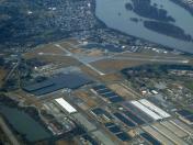
Coordinates: N40°13.03' / W76°51.08'Located 03 miles SE of Harrisburg, Pennsylvania on 320 acres of land. View all Airports in Pennsylvania.
Surveyed Elevation is 346 feet MSL.
HIGH TERRAIN SOUTH RWY 12/30. TPA 1500(1153) CONVENTIONAL.
Operations Data
|
|
Airport Communications
| ATIS: | 134.95 |
|---|---|
| ASOS: | Tel. 717-770-0880 |
| CAPITAL CITY TOWER: | 119.5 257.8 |
| CAPITAL CITY GROUND: | 121.9 |
| HARRISBURG APPROACH: | 124.1 273.525 |
| HARRISBURG DEPARTURE: | 124.1 273.525 |
| PTD: | 229.55 34.3FM |
| UNICOM: | 122.950 |
| EMERG: | 121.5 243.0 |
| CTAF: | 119.500 |
| ASOS at MDT (3.8 E): | 717-944-1372 |
| ATIS at MDT (4.3 E): | 118.8 |
| ASOS at THV (18.0 S): | 119.275 717-792-5529 |
Nearby Navigation Aids
|
| ||||||||||||||||||||||||||||||||||||||||||||||||||||||||||||
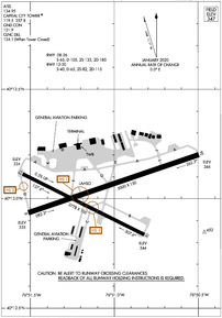
Runway 08/26
| Dimensions: | 5000 x 150 feet / 1524 x 46 meters | |
|---|---|---|
| Surface: | Asphalt / Grooved in Good Condition | |
| Weight Limits: | S-65, D-105, ST-185
& RWY 12/30, PPR FOR LOADS OVER 100,000 LBS.
| |
| Edge Lighting: | High Intensity | |
| Runway 08 | Runway 26 | |
| Coordinates: | N40°12.94' / W76°51.51' | N40°13.20' / W76°50.50' |
| Elevation: | 334.7 | 346.4 |
| Traffic Pattern: | Left | Right |
| Runway Heading: | 71° True | 251° True |
| Markings: | Precision Instrument in good condition. | Non-Precision Instrument in good condition. |
| Glide Slope Indicator | P4R (3.00° Glide Path Angle) RWY 08 PAPI UNUSBL BYD 7 DEGS RIGHT OF CRS. | V4L (3.10° Glide Path Angle) |
| RVR Equipment | Touchdown | |
| Approach Lights: | MALSR 1,400 Foot Medium-intensity Approach Lighting System with runway alignment indicator lights. | |
| Obstacles: | 75 ft Trees 1883 ft from runway, 611 ft left of center | 15 ft Pole 445 ft from runway, 289 ft right of center RWY 26 +7 FT ROAD;GOLF COURSE, +6 FT FENCE EAST AND SOUTH OF RWY END. |
Runway 12/30
| Dimensions: | 3778 x 100 feet / 1152 x 30 meters | |
|---|---|---|
| Surface: | Asphalt in Good Condition | |
| Weight Limits: | S-40, D-65, ST-115 | |
| Edge Lighting: | Medium Intensity | |
| Runway 12 | Runway 30 | |
| Coordinates: | N40°13.11' / W76°51.55' | N40°12.83' / W76°50.82' |
| Elevation: | 333.9 | 343.6 |
| Traffic Pattern: | Right | Left |
| Runway Heading: | 117° True | 297° True |
| Markings: | Non-Precision Instrument in good condition. | Non-Precision Instrument in good condition. |
| Glide Slope Indicator | V4L (3.90° Glide Path Angle) | V4L (4.00° Glide Path Angle) |
| Obstacles: | 38 ft Trees 424 ft from runway, 82 ft left of center | |
Services Available
| Fuel: | 100LL (blue), Jet-A |
|---|---|
| Transient Storage: | Hangars,Tiedowns |
| Airframe Repair: | MAJOR |
| Engine Repair: | MAJOR |
| Bottled Oxygen: | NOT AVAILABLE |
| Bulk Oxygen: | NOT AVAILABLE |
| Other Services: | AVIONICS,CHARTER SERVICE,PILOT INSTRUCTION |
Ownership Information
| Ownership: | Publicly owned | |
|---|---|---|
| Owner: | SUSQUEHANNA REG ARPT AUTH | |
| ONE TERMINAL DRIVE, SUITE 30 | ||
| MIDDLETOWN, PA 17057 | ||
| 717-948-3900 | ||
| Manager: | TIM EDWARDS | |
| ONE TERMINAL DRIVE, SUITE 30 | ||
| MIDDLETOWN, PA 17057 | ||
| 717-774-8335 | ||
Other Remarks
- PPR FOR HAZARDOUS CARGO.
- ARPT CLSD TO FAR PART 121 ACFT.
- BIRD FLOCKS ON & INVOF ARPT.
- ALERT: ACTIVE TXY PRIOR TO RY 12 RELOCATED THLD, NO T/O OR LNDG ON THIS SURFACE.
- FOR CD WHEN ATCT CLSD CTC HARRISBURG APCH 124.1 OR 800-932-0712.
- USE CTN: DUE TO PROXIMITY & RWY ALMNT, AIRCREWS HAVE MISTAKEN MDT RWY13/31 FOR CXY RWY 12/30 WHICH IS 4 NM W.
- WHEN ATCT CLSD ACTVT MALSR RWY 08; HIRL RWY 08/26; MIRL RWY 12/30 & TWY LGTS - CTAF.
- HIGH TERRAIN SOUTH RWY 12/30. TPA 1500(1153) CONVENTIONAL.
Weather Minimums
Instrument Approach Procedure (IAP) Charts
Nearby Airports with Instrument Procedures
| ID | Name | Heading / Distance | ||
|---|---|---|---|---|
 |
KMDT | Harrisburg International Airport | 109° | 4.3 |
 |
58N | Reigle Field Airport | 071° | 13.3 |
 |
N71 | Donegal Springs Airpark Airport | 120° | 14.8 |
 |
N94 | Carlisle Airport | 263° | 14.9 |
 |
KTHV | York Airport | 183° | 18.0 |
 |
08N | Keller Brothers Airport | 079° | 24.4 |
 |
74N | Bendigo Airport | 033° | 24.5 |
 |
9D4 | Deck Airport | 071° | 25.3 |
 |
KLNS | Lancaster Airport | 102° | 26.2 |
 |
W05 | Gettysburg Regional Airport | 221° | 29.8 |
 |
P34 | Mifflintown Airport | 312° | 34.2 |
 |
KSEG | Penn Valley Airport | 359° | 36.2 |


Comments
Skyport Aviation
World class facility and excellent friendly service. Will visit again.
Pages