Login
Register
W63
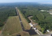
Lake Country Regional Airport
Official FAA Data Effective 2024-10-31 0901Z
VFR Chart of W63
Sectional Charts at SkyVector.com
IFR Chart of W63
Enroute Charts at SkyVector.com
Location Information for W63
Coordinates: N36°35.78' / W78°33.58'Located 02 miles S of Clarksville, Virginia on 100 acres of land. View all Airports in Virginia.
Estimated Elevation is 420 feet MSL.
Operations Data
|
|
Airport Communications
| AWOS-3: | 118.225 Tel. 434-374-2431 |
|---|---|
| CTAF: | 122.900 |
| AWOS-3 at CXE (12.1 N): | 121.225 434-372-4506 |
| AWOS-3 at HNZ (14.1 S): | 118.625 919-693-9516 |
| AWOS-3 at W78 (15.4 NW): | 119.425 434-575-0332 |
- APCH/DEP SVC PRVDD BY WASHINGTON ARTCC ON FREQS 118.75/377.1 (GREEN BAY RCAG).
Nearby Navigation Aids
|
| ||||||||||||||||||||||||||||||||||||||||||||||||||||||||||||
Runway 04/22
| Dimensions: | 4007 x 50 feet / 1221 x 15 meters | |
|---|---|---|
| Surface: | Asphalt in Excellent Condition | |
| Weight Limits: | S-12 | |
| Edge Lighting: | Medium Intensity | |
| Runway 04 | Runway 22 | |
| Coordinates: | N36°35.49' / W78°33.77' | N36°36.07' / W78°33.39' |
| Elevation: | 373.7 | 411.8 |
| Traffic Pattern: | Left | Left |
| Runway Heading: | 28° True | 208° True |
| Displaced Threshold: | 480 Feet | |
| Markings: | Non-Precision Instrument in good condition. | Basic in good condition. |
| Obstacles: | 37 ft Tree 601 ft from runway, 272 ft left of center CLOSE-IN OBSTRUCTION, 15 FT ABOVE RWY SURFACE, 64 FT FROM THR, 178 FT RIGHT OF CENTERLINE ON APPROACH. |
18 ft Road 200 ft from runway RYW 22 APCH SLOPE 15:1 TO DSPLCD THR FROM 82 FT TREE 1502 FT FR DSPLCD THR, 142 FT L. ROAD CROSSING 170 FT FROM END OF RWY. BUILDING 27 FT, 90 FT FROM END OF RWY, 110 FT L. |
Services Available
| Fuel: | 100LL (blue) |
|---|---|
| Transient Storage: | Tiedowns |
| Airframe Repair: | NONE |
| Engine Repair: | NONE |
| Bottled Oxygen: | NONE |
| Bulk Oxygen: | NONE |
Ownership Information
| Ownership: | Publicly owned | |
|---|---|---|
| Owner: | LAKE COUNTRY REG AIRPORT COMMISSION | |
| LAKE COUNTRY REGIONAL AIRPORT, POST OFFICE BOX 1047 | ||
| CLARKSVILLE, VA 23927 | ||
| 434-374-8028 | ||
| Manager: | MICHAEL DENTON | |
| LAKE COUNTRY REGIONAL AIRPORT, 11632 HWY 15 | ||
| CLARKSVILLE, VA 23927 | ||
| 434-374-8028 | ||
Other Remarks
- WILDLIFE INVOF ARPT.
- SELF SVC FUEL AVBL.
- FOR CD CTC WASHINGTON ARTCC AT 703-771-3587.
Weather Minimums
Instrument Approach Procedure (IAP) Charts
Nearby Airports with Instrument Procedures
| ID | Name | Heading / Distance | ||
|---|---|---|---|---|
 |
KCXE | Chase City Municipal Airport | 013° | 11.8 |
 |
KHNZ | Henderson/Oxford Airport | 174° | 14.2 |
 |
W78 | William M Tuck Airport | 296° | 15.5 |
 |
KAVC | Mecklenburg-Brunswick Regional Airport | 077° | 25.0 |
 |
KTDF | Raleigh Regional At Person County Airport | 227° | 27.8 |
 |
W31 | Lunenburg County Airport | 039° | 28.3 |
 |
KLHZ | Triangle North Exec Airport | 161° | 36.1 |
 |
KDAN | Danville Regional Airport | 268° | 37.6 |
 |
KLVL | Brunswick County Airport | 073° | 38.5 |
 |
0V4 | Brookneal/Campbell County Airport | 326° | 39.4 |
 |
KBKT | Allan C Perkinson/Blackstone AAF Airport | 045° | 41.0 |
 |
W81 | Crewe Municipal Airport | 032° | 41.5 |


