Login
Register
LAW
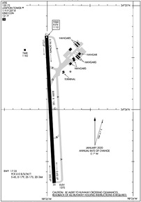
Lawton-Fort Sill Regional Airport
Official FAA Data Effective 2025-03-20 0901Z
VFR Chart of KLAW
Sectional Charts at SkyVector.com
IFR Chart of KLAW
Enroute Charts at SkyVector.com
Location Information for KLAW
Coordinates: N34°34.06' / W98°25.00'Located 02 miles S of Lawton, Oklahoma on 1300 acres of land. View all Airports in Oklahoma.
Surveyed Elevation is 1110 feet MSL.
Operations Data
|
|
Airport Communications
| ATIS: | 120.75 |
|---|---|
| ASOS: | 120.75 Tel. 580-581-1351 |
| LAWTON TOWER: | 119.9 257.8 |
| LAWTON GROUND: | 121.9 |
| FORT SILL APPROACH: | 120.55 322.4 |
| FORT SILL DEPARTURE: | 120.55 322.4 |
| UNICOM: | 122.950 |
| EMERG: | 121.5 243.0 |
| CTAF: | 119.900 |
| ATIS at FSI (5.0 N): | 135.425 |
| AWOS-3 at DUC (23.3 E): | 119.075 580-252-4547 |
| ASOS at FDR (31.0 SW): | 132.675 580-335-7591 |
Nearby Navigation Aids
|
| ||||||||||||||||||||||||||||||||||||||||||||||||||||||
Runway 17/35
| Dimensions: | 8599 x 150 feet / 2621 x 46 meters | |
|---|---|---|
| Surface: | Concrete / Wire Combed in Good Condition | |
| Weight Limits: | S-45, D-179, ST-344
PCR VALUE: 610/R/B/W/T
| |
| Edge Lighting: | High Intensity | |
| Runway 17 | Runway 35 | |
| Coordinates: | N34°34.71' / W98°25.03' | N34°33.30' / W98°24.94' |
| Elevation: | 1110.3 | 1070.1 |
| Traffic Pattern: | Left | Left |
| Runway Heading: | 177° True | 357° True |
| Declared Distances: | TORA:8599 TODA:8599 ASDA:8599 LDA:8599 | TORA:8599 TODA:8599 ASDA:8599 LDA:8599 |
| Markings: | Precision Instrument in fair condition. | Precision Instrument in fair condition. |
| Glide Slope Indicator | P4R (3.00° Glide Path Angle) | |
| Approach Lights: | MALSR 1,400 Foot Medium-intensity Approach Lighting System with runway alignment indicator lights. | |
| REIL: | Yes | |
| Obstacles: | 72 ft Pole 3100 ft from runway, 170 ft right of center | |
Services Available
| Fuel: | 100LL (blue), Jet A-1+ |
|---|---|
| Transient Storage: | Hangars,Tiedowns |
| Airframe Repair: | MAJOR |
| Engine Repair: | MAJOR |
| Bottled Oxygen: | NONE |
| Bulk Oxygen: | HIGH/LOW |
| Other Services: | AIR FREIGHT SERVICES,CARGO HANDLING SERVICES,PILOT INSTRUCTION,AIRCRAFT RENTAL |
Ownership Information
| Ownership: | Publicly owned | |
|---|---|---|
| Owner: | CITY OF LAWTON | |
| BOX 531 | ||
| LAWTON, OK 73502 | ||
| 580-581-3301 | ||
| Manager: | BARBARA MCNALLY | |
| 3401 S 11TH ST | ||
| LAWTON, OK 73501 | ||
| 580-353-4869 | EXTENSION 301. | |
Other Remarks
- THIS AIRPORT HAS BEEN SURVEYED BY THE NATIONAL GEODETIC SURVEY.
- WHEN ATCT CLSD ARFF AVBL THROUGH FORT SILL APCH.
- BIRDS ON & INVOF ARPT.
- WHEN ATCT CLSD, FOR CD CTC FORT WORTH ARTCC AT 817-858-7584.
- ATCT CTLS ALL RWY & TWY LGTG WHEN OPEN; WHEN ATCT CLSD, MALSR RWY 35; REIL RWY 17; HIRL RWY 17/35; TWY LGTG ON MED INTST. INCR/DECR INTST - CTAF. PAPI RWY 17 ON CONSLY, VRBL INTST - CTAF.
Weather Minimums
Instrument Approach Procedure (IAP) Charts
Nearby Airports with Instrument Procedures
| ID | Name | Heading / Distance | ||
|---|---|---|---|---|
 |
KDUC | Halliburton Field Airport | 104° | 23.4 |
 |
KFDR | Frederick Regional Airport | 245° | 31.0 |
 |
KSPS | Sheppard AFB/Wichita Falls Municipal Airport | 186° | 34.9 |
 |
KCHK | Chickasha Municipal Airport | 034° | 38.7 |
 |
KHBR | Hobart Regional Airport | 308° | 40.4 |
 |
KLTS | Altus AFB Airport | 278° | 42.6 |
 |
KCWC | Kickapoo Downtown Airport | 184° | 42.5 |
 |
KAXS | Altus/Quartz Mountain Regional Airport | 280° | 46.3 |
 |
F05 | Wilbarger County Airport | 244° | 47.7 |
 |
2O8 | Hinton Municipal Airport | 003° | 56.4 |
 |
KRQO | El Reno Regional Airport | 020° | 57.9 |
 |
2K4 | Scott Field Airport | 289° | 58.3 |


