Login
Register
VG07
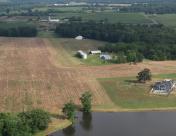
Rular Airport
Official FAA Data Effective 2024-10-31 0901Z
VFR Chart of VG07
Sectional Charts at SkyVector.com
IFR Chart of VG07
Enroute Charts at SkyVector.com
Location Information for VG07
Coordinates: N38°32.33' / W77°49.70'Located 01 miles W of Remington, Virginia on 4 acres of land. View all Airports in Virginia.
Estimated Elevation is 305 feet MSL.
Operations Data
|
|
Airport Communications
| AWOS-3 at CJR (1.6 SW): | 119.325 540-727-0523 |
|---|---|
| AWOS-3 at HWY (6.1 NE): | 120.350 540-788-4078 |
| ATIS at HEF (18.3 NE): | 125.175 |
Nearby Navigation Aids
|
| ||||||||||||||||||||||||||||||||||||||||||||||||||||||||||||
Runway 14/32
| Dimensions: | 1500 x 75 feet / 457 x 23 meters | |
|---|---|---|
| Surface: | Turf | |
| Runway 14 | Runway 32 | |
| Traffic Pattern: | Right | |
Ownership Information
| Ownership: | Privately Owned | |
|---|---|---|
| Owner: | LARRY L. SETTI | |
| 12028 FREEMAN'S FORD ROAD | ||
| REMINGTON, VA 22734 | ||
| 540-905-1870 | ||
| Manager: | LARRY L. SETTI | OTHER EMAIL: FITEAFOU@GMAIL.COM |
| 12028 FREEMAN'S FORD ROAD | ||
| REMINGTON, VA 22734 | ||
| 540-905-1870 | ||
Other Remarks
- FOR CD CTC POTOMAC APCH AT 866-709-4993.
Nearby Airports with Instrument Procedures
| ID | Name | Heading / Distance | ||
|---|---|---|---|---|
 |
KCJR | Culpeper Regional Airport | 241° | 1.7 |
 |
KHWY | Warrenton/Fauquier Airport | 062° | 6.2 |
 |
KHEF | Manassas Regional/Harry P Davis Field Airport | 053° | 18.3 |
 |
KRMN | Stafford Regional Airport | 115° | 19.4 |
 |
KOMH | Orange County Airport | 210° | 20.3 |
 |
KEZF | Shannon Airport | 132° | 24.2 |
 |
KNYG | Quantico Mcaf (Turner Field) Airport | 094° | 24.7 |
 |
KGVE | Gordonsville Municipal Airport | 214° | 27.9 |
 |
KIAD | Washington Dulles International Airport | 035° | 30.0 |
 |
KFRR | Front Royal-Warren County Airport | 318° | 30.2 |
 |
KDAA | Davison AAF Airport | 070° | 32.2 |
 |
KLKU | Louisa County/Freeman Field Airport | 191° | 32.4 |


