Login
Register
2S1
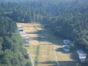
Vashon Municipal Airport
Official FAA Data Effective 2024-10-31 0901Z
VFR Chart of 2S1
Sectional Charts at SkyVector.com
IFR Chart of 2S1
Enroute Charts at SkyVector.com
Location Information for 2S1
Coordinates: N47°27.52' / W122°28.62'Located 01 miles NW of Vashon, Washington on 20 acres of land. View all Airports in Washington.
Surveyed Elevation is 316 feet MSL.
Operations Data
|
|
Airport Communications
| CTAF: | 122.900 |
|---|---|
| D-ATIS at SEA (6.7 E): | 118.0 |
| ASOS at SEA (6.7 E): | 206-214-2592 |
| ATIS at BFI (8.3 NE): | 127.75 |
Nearby Navigation Aids
|
| ||||||||||||||||||||||||||||||||||||||||||||||||
Runway 17/35
| Dimensions: | 2001 x 60 feet / 610 x 18 meters | |
|---|---|---|
| Surface: | Turf in Good Condition | |
| Edge Lighting: | Non-Standard NSTD LIRL; THR LGTS NON-STD COLORS 360 DEG GREEN. | |
| Runway 17 | Runway 35 | |
| Coordinates: | N47°27.68' / W122°28.59' | N47°27.35' / W122°28.65' |
| Elevation: | 316.0 | 308.0 |
| Traffic Pattern: | Right | Left |
| Runway Heading: | 187° True | 7° True |
| Obstacles: | 41 ft Trees 0 ft from runway, 78 ft left of center +5 FT FENCE & DIRT RD APRX 182 FT FM THR. |
30 ft Trees 0 ft from runway, 90 ft left of center TREES IN PRIM SFC AT THLD; GRAVEL RD 45 FT RIGHT AT THLD. |
Helipad H1
FOR MEDIVAC EMERG MED SVCS ONLY. | ||
| Dimensions: | 98 x 98 feet / 30 x 30 meters | |
|---|---|---|
| Surface: | Turf | |
| Edge Lighting: | Non-Standard G PERIMETER LGTS. | |
Services Available
| Fuel: | NONE |
|---|---|
| Transient Storage: | Tiedowns PILOTS BRING OWN TIEDOWNS. |
| Airframe Repair: | NOT AVAILABLE |
| Engine Repair: | NOT AVAILABLE |
| Bottled Oxygen: | NONE |
| Bulk Oxygen: | NONE |
| Other Services: | PILOT INSTRUCTION |
Ownership Information
| Ownership: | Publicly owned | |
|---|---|---|
| Owner: | KING CO ARPT DIST NR ONE | |
| P.O. BOX 1639 | ||
| VASHON, WA 98070 | ||
| (206) 463-3142 | ||
| Manager: | KEVAN YALOWITZ | |
| 19710 87TH AVE SW | ||
| VASHON, WA 98070 | ||
| 202-641-2050 | ||
Other Remarks
- NGT OPNS ONLY FOR PILOTS FAMILIAR WITH APT CLOSE IN OBSTNS, ALL QUADRANTS.
- HILL 5-10 FT W OF RWY EDGE THE FULL LEN.
- GATE COMBINATION 1168.
- FOR CD CTC SEATTLE APCH AT 206-214-4723.
- OCNL LARGE WILD ANIMALS ON ARPT.
- RWY 17/35 SOFT WHEN WET.
- HANGARS 90 FT E & W OF CNTRLN.
- NOISE ABATEMENT PROCS IN EFCT. CTC AMGR 202-641-2050.
- TOUCH & GO LDGS NOT RECOMMENDED.
- TURBULENCE PSBL AT N END OF RY 17/35 WITH STRONG CROSSWINDS.
- RCMD CLG FOR FLD CONDS 202-641-2050.
- HEL PARKING AREA RSTRD TO MEDEVAC OPNS.
Nearby Airports with Instrument Procedures
| ID | Name | Heading / Distance | ||
|---|---|---|---|---|
 |
KSEA | Seattle-Tacoma International Airport | 094° | 6.7 |
 |
KBFI | Boeing Field/King County International Airport | 058° | 8.3 |
 |
KRNT | Renton Municipal Airport | 078° | 10.8 |
 |
KPWT | Bremerton Ntl Airport | 279° | 11.9 |
 |
KTIW | Tacoma Narrows Airport | 199° | 12.2 |
 |
S50 | Auburn Municipal Airport | 127° | 12.9 |
 |
KTCM | Mcchord Field (Joint Base Lewis-Mcchord) Airport | 179° | 19.3 |
 |
KPLU | Pierce County/Thun Field Airport | 159° | 22.7 |
 |
KGRF | Gray AAF (Joint Base Lewis-Mcchord) Airport | 190° | 23.2 |
 |
KPAE | Seattle Paine Field International Airport | 016° | 28.1 |
 |
KSHN | Sanderson Field Airport | 243° | 30.5 |
 |
S43 | Harvey Field Airport | 029° | 30.8 |


