Login
Register
74CA
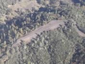
Flying Gluepie Ranch Airport
Official FAA Data Effective 2024-12-26 0901Z
VFR Chart of 74CA
Sectional Charts at SkyVector.com
IFR Chart of 74CA
Enroute Charts at SkyVector.com
Location Information for 74CA
Coordinates: N38°28.05' / W120°48.20'Located 03 miles SW of Fiddletown, California on 341 acres of land. View all Airports in California.
Estimated Elevation is 1451 feet MSL.
Operations Data
|
|
Airport Communications
| AWOS-3 at JAQ (5.6 S): | 121.125 209-257-1292 |
|---|---|
| AWOS-3 at PVF (15.4 N): | 128.125 530-622-5698 |
| AWOS-1 at O61 (15.6 NW): | 120.0 530-677-5392 |
Nearby Navigation Aids
|
| ||||||||||||||||||||||||||||||||||||
Runway 09/27
| Dimensions: | 807 x 20 feet / 246 x 6 meters | |
|---|---|---|
| Surface: | Gravel | |
| Runway 09 | Runway 27 | |
| Coordinates: | N38°28.07' / W120°48.28' | N38°28.03' / W120°48.11' |
| Elevation: | 1435.0 | 1451.0 |
| Traffic Pattern: | Right | |
| Runway Heading: | 104° True | 284° True |
Ownership Information
| Ownership: | Privately Owned | |
|---|---|---|
| Owner: | JIM & SASKIA DONOVAN | |
| PO BOX 333 | ||
| FIDDLETOWN, CA 95629 | ||
| 747-231-7474 | ||
| Manager: | JIM & SASKIA DONOVAN | |
| PO BOX 333 | ||
| FIDDLETOWN, CA 95629 | ||
| 747-231-7474 | ||
Other Remarks
- FOR CD CTC OAKLAND ARTCC AT 510-745-3380.
Nearby Airports with Instrument Procedures
| ID | Name | Heading / Distance | ||
|---|---|---|---|---|
 |
KJAQ | Westover Field Amador County Airport | 175° | 5.5 |
 |
KPVF | Placerville Airport | 008° | 15.6 |
 |
KCPU | Calaveras County/Maury Rasmussen Field Airport | 159° | 20.6 |
 |
KMHR | Sacramento Mather Airport | 282° | 23.8 |
 |
1O3 | Lodi Airport | 234° | 27.1 |
 |
KMCC | Mc Clellan Airfield Airport | 293° | 30.6 |
 |
O22 | Columbia Airport | 144° | 32.0 |
 |
KAUN | Auburn Municipal Airport | 335° | 32.0 |
 |
KSAC | Sacramento Exec Airport | 274° | 32.6 |
 |
KLHM | Lincoln Regional/Karl Harder Field Airport | 315° | 36.9 |
 |
KSMF | Sacramento International Airport | 290° | 39.5 |
 |
KSCK | Stockton Metro Airport | 211° | 40.1 |


