Login
Register
6Y3
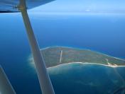
North Fox Island Airport
Official FAA Data Effective 2024-11-28 0901Z
VFR Chart of 6Y3
Sectional Charts at SkyVector.com
IFR Chart of 6Y3
Enroute Charts at SkyVector.com
Location Information for 6Y3
Coordinates: N45°28.93' / W85°46.85'Located 01 miles NE of North Fox Island, Michigan. View all Airports in Michigan.
Estimated Elevation is 639 feet MSL.
Operations Data
|
|
Airport Communications
| CTAF: | 122.900 |
|---|---|
| AWOS-3 at SJX (15.5 NE): | 118.075 231-448-3081 |
| AWOS-3P at CVX (24.1 SE): | 120.0 231-237-9703 |
| AWOS-3 at ISQ (33.8 NW): | 118.775 906-341-8585 |
Nearby Navigation Aids
|
| ||||||||||||||||||||||||||||||||||||||||||||||||||||||||||||
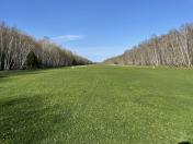
Runway 07/25
| Dimensions: | 3001 x 100 feet / 915 x 30 meters | |
|---|---|---|
| Surface: | Turf | |
| Runway 07 | Runway 25 | |
| Coordinates: | N45°28.80' / W85°47.15' | N45°29.05' / W85°46.55' |
| Elevation: | 639.0 | 639.0 |
| Runway Heading: | 60° True | 240° True |
| Displaced Threshold: | 804 Feet | 999 Feet |
| Obstacles: | 36 ft Trees 10 ft from runway, 65 ft left of center | 63 ft Trees 0 ft from runway, 80 ft left of center |
Services Available
| Fuel: | NONE |
|---|---|
| Transient Storage: | Tiedowns TIEDOWNS NOT PRVDD. |
| Airframe Repair: | NOT AVAILABLE |
| Engine Repair: | NOT AVAILABLE |
| Bottled Oxygen: | NOT AVAILABLE |
| Bulk Oxygen: | NOT AVAILABLE |
Ownership Information
| Ownership: | Publicly owned | |
|---|---|---|
| Owner: | MICHIGAN DEPT OF NATURAL RESOURCES | |
| 8015 S MACKINAW TRL | ||
| CADILLAC, MI 49601-9746 | ||
| 231-775-9727 | EXTN 6030 OR 231-732-3541 EXTN 5430. | |
| Manager: | GENERAL GRANT | |
| 1711 W COLLEGE ST | ||
| BOZEMAN, MT 59715-4913 | ||
| 313-912-6161 | ||
Other Remarks
- REMOTE ISLAND, NO SVCS & NO SHELTER & NO CELL PHONE COVERAGE.
- WATCH FOR ACFT TAXIING & TAKING OFF BFR LDG.
- SAFETY BRIEFING & PILOT INFO AVBL AT HTTPS://THERAF.ORG/
- BIRDS, WILDLIFE, & SNAKES ON & INVOF ARPT.
- ARPT CLSD NOV-APR & WHEN SNOW COVD; RWYS NOT PLOWED & SOFT IN SPRING & AFT RAIN.
- TALL TREES ALQUADS.
- SEE DNR RULES POSTED NEAR PRKG.
- FOR CD CTC MINNEAPOLIS ARTCC AT 651-463-5588.
- OVERFLY THE FLD BFR ENTERING TFC PAT.
- RWY & DTHR MKD WITH 3 FT YELLOW CONES.
- RWY & DTHR MKD WITH 3 FT YELLOW CONES.
Nearby Airports with Instrument Procedures
| ID | Name | Heading / Distance | ||
|---|---|---|---|---|
 |
KSJX | Beaver Island Airport | 035° | 15.5 |
 |
KCVX | Charlevoix Municipal Airport | 116° | 23.9 |
 |
KISQ | Schoolcraft County Airport | 331° | 33.8 |
 |
KMGN | Harbor Springs Airport | 094° | 36.8 |
 |
N98 | Boyne City Municipal Airport | 115° | 37.3 |
 |
KACB | Antrim County Airport | 139° | 38.6 |
 |
KBFA | Boyne Mountain Airport | 117° | 40.9 |
 |
KPLN | Pellston Regional/Emmet County Airport | 082° | 41.9 |
 |
KTVC | Cherry Capital Airport | 169° | 45.2 |
 |
2P2 | Washington Island Airport | 263° | 48.6 |
 |
83D | Mackinac County Airport | 060° | 50.3 |
 |
KERY | Luce County Airport | 015° | 51.6 |


Comments
Back Country in Michigan
A great place for nature and hikes on the roads around the 800 acre island. The runway is in great shape and it's worth the stop and suitable for many aircraft.
It's a volunteer run airport on state land. It's very remote with nearly no cell service. However the runway is excellently maintained by the volunteers.
Be mindful that this is an esspecially difficult place to keep open. They ask that you don't waste materials that are there and please fly your trash out when you leave. There is a rustic camping setup on the north side of the 07 threshold. Read the Notams and be cautious about landing with less than 8.50 tires after rain. After a few days of dry weather it's solid and a top notch grass strip. Watch weather before you go. Without cell service your eyes are possibly your only weather source after you land.