Login
Register


54W
Albany Airport
Official FAA Data Effective 2026-02-19 0901Z
Chart Supplement

VFR Chart of 54W
Sectional Charts at SkyVector.com
IFR Chart of 54W
Enroute Charts at SkyVector.com
Location Information for 54W
Coordinates: N42°43.04' / W89°25.45'Located 01 miles NE of Albany, Wisconsin. View all Airports in Wisconsin.
Estimated Elevation is 820 feet MSL.
Operations Data
|
|
Airport Communications
| CTAF: | 122.900 |
|---|---|
| AWOS-3 at EFT (9.6 SW): | 118.375 608-328-8359 |
| AWOS-3 at JVL (17.8 E): | 608-758-1723 |
| ATIS at JVL (17.9 E): | 128.25 |
Nearby Navigation Aids
|
| ||||||||||||||||||||||||||||||||||||||||||||||||


Runway 09/27
| Dimensions: | 1675 x 100 feet / 511 x 30 meters | |
|---|---|---|
| Surface: | Turf in Fair Condition | |
| Runway 09 | Runway 27 | |
| Coordinates: | N42°43.04' / W89°25.64' | N42°43.05' / W89°25.26' |
| Elevation: | 820.0 | 815.0 |
| Traffic Pattern: | Left | Left |
| Runway Heading: | 88° True | 268° True |
| Obstacles: | 45 ft Trees 10 ft from runway, 125 ft left of center | |
Services Available
| Fuel: | NONE |
|---|---|
| Transient Storage: | NONE |
| Airframe Repair: | NONE |
| Engine Repair: | NONE |
| Bottled Oxygen: | NOT AVAILABLE |
| Bulk Oxygen: | NONE |
Ownership Information
| Ownership: | Privately Owned | |
|---|---|---|
| Owner: | ALBANY AIRPORT LLC | |
| W9478 WHITE OAK RD | ||
| ARGYLE, WI 53504 | ||
| 608-290-1615 | ||
| Manager: | PAUL WAGNER | |
| W9478 WHITE OAK RD | ||
| ARGYLE, WI 53504 | ||
| 608-438-0017 | ||
Other Remarks
- CONTACT ARPT MGR FOR WINTER RUNWAY CONDITIONS 608-438-0017.
- FOR CD CTC CHICAGO ARTCC AT 630-906-8921.
- DEER & BIRDS ON & INVOF ARPT.
Nearby Airports with Instrument Procedures
| ID | Name | Heading / Distance | ||
|---|---|---|---|---|
 |
KEFT | Monroe Municipal Airport | 230° | 9.6 |
|
KJVL | Southern Wisconsin Regional Airport | 108° | 17.9 |
|
44C | Beloit Airport | 122° | 24.1 |
|
C29 | Middleton Municipal/Morey Field Airport | 348° | 24.3 |
|
87Y | Blackhawk Airfield Airport | 024° | 25.5 |
|
KMSN | Dane County Regional/Truax Field Airport | 008° | 25.6 |
|
KFEP | Albertus Airport | 193° | 29.1 |
|
61C | Fort Atkinson Municipal Airport | 060° | 30.6 |
|
KRFD | Chicago/Rockford International Airport | 155° | 34.5 |
|
C77 | Poplar Grove Airport | 132° | 35.2 |
|
KMRJ | Iowa County Airport | 286° | 37.3 |
|
91C | Sauk/Prairie Airport | 337° | 37.8 |
Airport Images
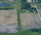
By: WisDOT Aeronautics


