Login
Register


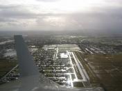
7S5
Independence State Airport
Official FAA Data Effective 2024-12-26 0901Z
Chart Supplement

VFR Chart of 7S5
Sectional Charts at SkyVector.com
IFR Chart of 7S5
Enroute Charts at SkyVector.com
Location Information for 7S5
Coordinates: N44°52.03' / W123°11.89'Located 01 miles NW of Independence, Oregon on 69 acres of land. View all Airports in Oregon.
Surveyed Elevation is 179 feet MSL.
Operations Data
|
|
Airport Communications
| CTAF: | 122.975 |
|---|---|
| UNICOM: | 122.975 |
| ASOS at SLE (8.7 E): | 124.55 503-371-1062 |
| ATIS at SLE (8.7 E): | 124.55 |
| AWOS-3PT at S12 (14.9 SE): | 119.925 541-967-3508 |
Nearby Navigation Aids
|
| ||||||||||||||||||||||||||||||||||||||||||||||||


Runway 16/34
| Dimensions: | 3002 x 60 feet / 915 x 18 meters | |
|---|---|---|
| Surface: | Asphalt in Good Condition | |
| Weight Limits: | S-12 | |
| Edge Lighting: | Medium Intensity | |
| Runway 16 | Runway 34 | |
| Coordinates: | N44°52.28' / W123°11.90' | N44°51.78' / W123°11.89' |
| Elevation: | 179.1 | 178.1 |
| Traffic Pattern: | Left | Left |
| Runway Heading: | 180° True | 360° True |
| Markings: | Basic in good condition. | Basic in good condition. |
| Glide Slope Indicator | P4R (3.00° Glide Path Angle) | P4L (3.00° Glide Path Angle) |
| Obstacles: | 15 ft Road 585 ft from runway, 175 ft left of center | |
Services Available
| Fuel: | 100LL (blue), Jet-A |
|---|---|
| Transient Storage: | Tiedowns |
| Airframe Repair: | NONE |
| Engine Repair: | NONE |
| Bottled Oxygen: | NONE |
| Bulk Oxygen: | NONE |
| Other Services: | GLIDER SERVICE,PILOT INSTRUCTION,AIRCRAFT RENTAL |
Ownership Information
| Ownership: | Publicly owned | |
|---|---|---|
| Owner: | OREGON DEPARTMENT OF AVIATION | |
| 3040 25TH ST SE | ||
| SALEM, OR 97302 | ||
| 503-378-8689 | ||
| Manager: | STATE AIRPORTS MANAGER | |
| 3040 25TH ST SE | ||
| SALEM, OR 97302-1125 | ||
| (503) 378-4880 | ||
Other Remarks
- ULTRALIGHT ACFT ON AND INVOF ARPT.
- MIGRATORY FLOCKS OF WATERFOWL ON AND INVOF ARPT.
- GLDR & ULTRALIGHTS USE R TFC FOR RWY 16/34.
- FOR CD CTC SEATTLE ARTCC AT 253-351-3694.
- CALM WIND USE RWY 34.
- SEASONAL STANDING WATER ON TWYS.
- ACTVT PAPI RWY 16 & 34; MIRL RWY 16/34 - CTAF.
Nearby Airports with Instrument Procedures
| ID | Name | Heading / Distance | ||
|---|---|---|---|---|
 |
KSLE | Mcnary Field Airport | 072° | 8.7 |
|
S12 | Albany Municipal Airport | 156° | 15.0 |
|
KMMV | Mc Minnville Municipal Airport | 007° | 19.8 |
|
KCVO | Corvallis Municipal Airport | 189° | 22.6 |
|
KUAO | Aurora State Airport | 038° | 29.2 |
|
KONP | Newport Municipal Airport | 245° | 40.6 |
|
KHIO | Portland-Hillsboro Airport | 014° | 41.8 |
|
KTMK | Tillamook Airport | 321° | 42.2 |
|
KEUG | Mahlon Sweet Field Airport | 180° | 44.6 |
|
KPDX | Portland International Airport | 030° | 50.3 |
|
KVUO | Pearson Field Airport | 026° | 50.7 |
|
KTTD | Portland-Troutdale Airport | 039° | 53.1 |
Airport Images

By: Wayne Nutsch
By: jdubner


