Login
Register


FCH
Fresno Chandler Exec Airport
Official FAA Data Effective 2024-04-18 0901Z
Chart Supplement

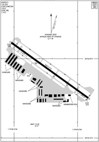
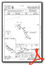
KFCH Airport Diagram
VFR Chart of KFCH
Sectional Charts at SkyVector.com
IFR Chart of KFCH
Enroute Charts at SkyVector.com
Location Information for KFCH
Coordinates: N36°43.93' / W119°49.22'Located 02 miles W of Fresno, California on 200 acres of land. View all Airports in California.
Surveyed Elevation is 279 feet MSL.
VFR HEL 520 FT AGL, VFR 1020 FT AGL.
Operations Data
|
|
Airport Communications
| AWOS-3: | 135.225 Tel. 559-488-1040 |
|---|---|
| FRESNO APPROACH: | 119.0 119.6 323.25 351.95 |
| FRESNO DEPARTURE: | 119.0 323.25 |
| CLEARANCE DELIVERY: | 119.0 |
| UNICOM: | 123.000 |
| CTAF: | 123.000 |
| ATIS at FAT (5.6 NE): | 121.35 |
| ASOS at FAT (5.6 NE): | 559-255-3413 |
| AWOS-3PT at O32 (18.3 E): | 120.175 559-637-9453 |
Nearby Navigation Aids
|
| ||||||||||||||||||||||||||||||||||||||||||||||||


Runway 12/30
| Dimensions: | 3627 x 75 feet / 1106 x 23 meters | |
|---|---|---|
| Surface: | Asphalt in Good Condition | |
| Weight Limits: | S-17 | |
| Edge Lighting: | Medium Intensity | |
| Runway 12 | Runway 30 | |
| Coordinates: | N36°44.10' / W119°49.52' | N36°43.75' / W119°48.92' |
| Elevation: | 278.1 | 279.2 |
| Traffic Pattern: | Right | Left |
| Runway Heading: | 125° True | 305° True |
| Displaced Threshold: | 415 Feet | 538 Feet |
| Markings: | Non-Precision Instrument in good condition. | Non-Precision Instrument in good condition. |
| Glide Slope Indicator | P2L (3.00° Glide Path Angle) | P4R (3.00° Glide Path Angle) |
| REIL: | Yes | Yes |
| Obstacles: | 15 ft Road 450 ft from runway, 150 ft left of center APCH RATIO 46:1 FM DSPLCD THR. |
15 ft Road 360 ft from runway, 140 ft left of center APCH RATIO 43:1 FM DSPLCD THR. |
Services Available
| Fuel: | 100LL (blue) |
|---|---|
| Transient Storage: | Hangars,Tiedowns |
| Airframe Repair: | MINOR |
| Engine Repair: | MINOR |
| Bottled Oxygen: | NOT AVAILABLE |
| Bulk Oxygen: | NONE |
| Other Services: | AVIONICS,CHARTER SERVICE,PILOT INSTRUCTION,AIRCRAFT RENTAL,AIRCRAFT SALES |
Ownership Information
| Ownership: | Publicly owned | |
|---|---|---|
| Owner: | CITY OF FRESNO | |
| 4995 E. CLINTON WAY | ||
| FRESNO, CA 93727-1525 | ||
| 559-621-4500 | ||
| Manager: | ALICIA MIRANDO | |
| 510 WEST KEARNEY BLVD | ||
| FRESNO, CA 93706 | ||
| (559) 621-4508 | ||
Operational Statistics
| Single Engine Aircraft Based on Field: | 90 | Statistics collected for 12 month period ending 2021-12-31 | |
|---|---|---|---|
| Multi-Engine Aircraft Based on Field: | 5 | Annual Commercial Operations: | none |
| Jet Aircraft Based on Field: | 1 | Annual Commuter Operations: | none |
| Helicopters Based on Field: | 3 | Annual Air Taxi Operations: | none |
| Military Aircraft Based on Field: | none | Annual Military Operations: | none |
| Gliders Based on Field: | none | Annual GA Local Operations: | 21320 |
| Ultralights Based on Field: | none | Annual GA Itinerant Operations: | 9530 |
Other Remarks
- NMRS BIRDS IN VCNTY OF ARPT.
- PRACTICE LDGS & LOW APCHS & TGL OR STOP-AND-GO OPNS AUTH ONLY BTN 0700-2200.
- RY 30 CALM WIND RY WHEN WIND REPORTED BY AWOS LESS THAN 5 KNOTS.
- RY 12 PRACTICE LDGS & LOW APCHS & TGL OR STOP-AND-GO OPNS NOT PERMITTED DUE TO NOISE SENSITIVE RESIDENTIAL AREAS SE OF ARPT.
- AFT TKOF CLIMB ON RY HEADING UNTIL PASSING 800 FT MSL; FOR SAFETY & NOISE ABATEMENT INITIAL CLIMBOUT AT BEST RATE-OF-CLIMB RECOMMENDED.
- FOR CD CTC FRESNO APCH AT 559-454-9828.
- 0LL 100LL FUEL AVBL 24/7
- ACTVT REIL RWY 12 & 30; PAPI RWY 12 & 30; MIRL RWY 12/30 AND TWY LGTS - CTAF BTN SS-SR.
- VFR HEL 520 FT AGL, VFR 1020 FT AGL.
Weather Minimums
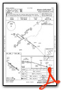
Instrument Approach Procedure (IAP) Charts
Nearby Airports with Instrument Procedures
| ID | Name | Heading / Distance | ||
|---|---|---|---|---|
 |
KFAT | Fresno Yosemite International Airport | 061° | 5.6 |
|
O32 | Reedley Municipal Airport | 101° | 18.2 |
|
KMAE | Madera Municipal Airport | 317° | 20.8 |
|
KHJO | Hanford Municipal Airport | 159° | 26.6 |
|
F34 | Firebaugh Airport | 284° | 32.0 |
|
KVIS | Visalia Municipal Airport | 140° | 32.3 |
|
C80 | New Coalinga Municipal Airport | 214° | 41.2 |
|
KTLR | Mefford Field Airport | 145° | 42.0 |
|
KMCE | Merced Yosemite Regional Airport | 315° | 47.0 |
|
KMPI | Mariposa-Yosemite Airport | 347° | 47.8 |
|
KMER | Castle Airport | 317° | 52.9 |
|
KLSN | Los Banos Municipal Airport | 291° | 54.3 |
Airport Images
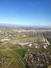
By: dgrutherford


