Login
Register


GOO
Nevada County Airport
Official FAA Data Effective 2026-02-19 0901Z
Chart Supplement

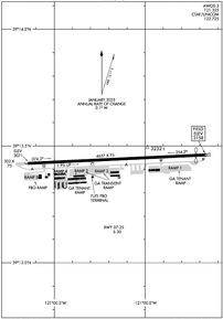
KGOO Airport Diagram
VFR Chart of KGOO
Sectional Charts at SkyVector.com
IFR Chart of KGOO
Enroute Charts at SkyVector.com
Location Information for KGOO
Coordinates: N39°13.44' / W121°0.15'Located 03 miles E of Grass Valley, California on 117 acres of land. View all Airports in California.
Surveyed Elevation is 3157 feet MSL.
Operations Data
|
|
Airport Communications
| AWOS-3: | 121.325 Tel. 530-273-0029 |
|---|---|
| NORCAL APPROACH: | 125.4 259.1 |
| NORCAL DEPARTURE: | 125.4 259.1 |
| CTAF: | 122.725 |
| UNICOM: | 122.725 |
| ASOS at BLU (14.0 E): | 120.075 530-212-0347 |
| AWOS-3 at AUN (16.6 S): | 119.375 530-888-8934 |
| ATIS at BAB (20.9 W): | 124.55 |
Nearby Navigation Aids
|
| ||||||||||||||||||||||||||||||||||||


Runway 07/25
| Dimensions: | 4657 x 75 feet / 1419 x 23 meters | |
|---|---|---|
| Surface: | Asphalt in Good Condition | |
| Weight Limits: | S-30 | |
| Edge Lighting: | Medium Intensity | |
| Runway 07 | Runway 25 | |
| Coordinates: | N39°13.43' / W121°0.65' | N39°13.46' / W120°59.66' |
| Elevation: | 3070.8 | 3157.7 |
| Traffic Pattern: | Left | Left |
| Runway Heading: | 87° True | 267° True |
| Displaced Threshold: | 304 Feet | |
| Markings: | Non-Precision Instrument in good condition. | Non-Precision Instrument in good condition. |
| Glide Slope Indicator | V4L (3.00° Glide Path Angle) | |
| Obstacles: | 20 ft Trees 612 ft from runway, 190 ft left of center | 100 ft Pole 2600 ft from runway, 235 ft right of center |
Services Available
| Fuel: | 100LL (blue), Jet-A |
|---|---|
| Transient Storage: | Tiedowns |
| Airframe Repair: | MAJOR |
| Engine Repair: | MAJOR |
| Bottled Oxygen: | NONE |
| Bulk Oxygen: | HIGH/LOW |
| Other Services: | AIR FREIGHT SERVICES,CHARTER SERVICE,PILOT INSTRUCTION,AIRCRAFT RENTAL |
Ownership Information
| Ownership: | Publicly owned | |
|---|---|---|
| Owner: | NEVADA COUNTY | |
| 950 MAIDU AVE | ||
| NEVADA CITY, CA 95959 | ||
| 530-273-3374 | ||
| Manager: | KEVIN EDWARDS | KEVIN.EDWARDS@NEVADACOUNTYCA.GOV |
| 13083 JOHN BAUER AVE | ||
| GRASS VALLEY, CA 95945-9533 | ||
| 530-273-3374 | ||
Other Remarks
- RWY 07/25 SLOPES 1.9 PCT DOWNHILL TO THE WEST. RWY 07 TKOFS NOT RCMDD DUE TO RISING TRRN.
- FOR CD CTC NORCAL APCH AT 916-361-6874.
- HELS MAKE STRAIGHT-IN APCHS AND DEPS.
- BE ALERT MAY-OCT FOR CALFIRE AIR TANKER OPS FLYING OVHD PAT FOR RWY 07 (SEE AIM 5-4-27 FOR MNVR AND PHRASEOLOGY). EXPC TANKERS TO DEP RWY 25 AND LAND RWY 07 REGARDLESS OF WIND COND.
- ACTVT VASI RWY 07; MIRL RWY 07/25 - CTAF.
Weather Minimums

Instrument Approach Procedure (IAP) Charts
Nearby Airports with Instrument Procedures
| ID | Name | Heading / Distance | ||
|---|---|---|---|---|
 |
KAUN | Auburn Municipal Airport | 192° | 16.6 |
|
KBAB | Beale AFB Airport | 255° | 20.9 |
|
KLHM | Lincoln Regional/Karl Harder Field Airport | 220° | 24.9 |
|
KMYV | Yuba County Airport | 254° | 27.5 |
|
KPVF | Placerville Airport | 158° | 32.2 |
|
KOVE | Oroville Municipal Airport | 298° | 32.9 |
|
KMCC | Mc Clellan Airfield Airport | 209° | 38.2 |
|
KTRK | Truckee-Tahoe Airport | 081° | 40.6 |
|
KSMF | Sacramento International Airport | 221° | 42.0 |
|
KMHR | Sacramento Mather Airport | 199° | 42.4 |
|
O08 | Colusa County Airport | 266° | 46.3 |
|
O02 | Nervino Airport | 040° | 46.7 |
Airport Images
Do you have a recent image of this airport? Upload it here!


