Login
Register


05C
Griffith-Merrillville Airport
Official FAA Data Effective 2025-12-25 0901Z
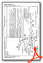
Chart Supplement

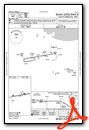
VFR Chart of 05C
Sectional Charts at SkyVector.com
IFR Chart of 05C
Enroute Charts at SkyVector.com
Location Information for 05C
Coordinates: N41°31.19' / W87°23.97'Located 02 miles E of Griffith, Indiana on 130 acres of land. View all Airports in Indiana.
Surveyed Elevation is 634 feet MSL.
Operations Data
|
|
Airport Communications
| CHICAGO APPROACH: | 133.1 285.6 |
|---|---|
| CHICAGO DEPARTURE: | 133.1 285.6 |
| LUCIT STAR: | 133.1 285.6 |
| UNICOM: | 123.000 |
| CTAF: | 123.000 |
| AWOS-3PT at GYY (5.8 N): | 134.575 219-944-0010 |
| D-ATIS at GYY (5.9 N): | 134.575 |
| AWOS-3PT at IGQ (5.9 W): | 124.925 708-889-6319 |
- COMMUNICATIONS PRVDD BY TERRE HAUTE RADIO ON FREQ 122.3 (CROWNPOINT RCO).
Nearby Navigation Aids
|
| ||||||||||||||||||||||||||||||||||||||||||||||||||||||||||||


Runway 08/26
| Dimensions: | 4899 x 75 feet / 1493 x 23 meters | |
|---|---|---|
| Surface: | Asphalt / Grooved in Good Condition | |
| Edge Lighting: | Medium Intensity | |
| Runway 08 | Runway 26 | |
| Coordinates: | N41°31.12' / W87°24.50' | N41°31.26' / W87°23.44' |
| Elevation: | 634.0 | 632.3 |
| Traffic Pattern: | Left | Left |
| Runway Heading: | 80° True | 260° True |
| Displaced Threshold: | 1120 Feet | |
| Markings: | Basic in good condition. | Basic in good condition. |
| Glide Slope Indicator | P2L (3.50° Glide Path Angle) | P2R (4.00° Glide Path Angle) |
| REIL: | Yes | Yes |
| Obstacles: | 12 ft Building 380 ft from runway, 125 ft left of center | 55 ft Trees 360 ft from runway APCH SLOPE 26:1 FM DTHR; 55 FT TREES 1480 FT FM DTHR. |
Services Available
| Fuel: | 100LL (blue), Jet-A, UL94 |
|---|---|
| Transient Storage: | Hangars,Tiedowns |
| Airframe Repair: | MAJOR |
| Engine Repair: | MAJOR |
| Bottled Oxygen: | LOW |
| Bulk Oxygen: | LOW |
| Other Services: | PILOT INSTRUCTION,AIRCRAFT RENTAL,AIRCRAFT SALES |
Ownership Information
| Ownership: | Publicly owned | |
|---|---|---|
| Owner: | GARY/CHICAGO INTL AIRPORT AUTHORITY | |
| 6001 AIRPORT ROAD | ||
| GARY, IN 46406 | ||
| 219-924-0207 | ||
| Manager: | CRAIG ANDERSON | |
| 1705 E. MAIN ST. | ||
| GRIFFITH, IN 46319 | ||
| 219-924-0207 | ||
Other Remarks
- DEER ON & INVOF ARPT.
- FOR CD CTC CHICAGO APCH AT 847-289-0926.
- UNATNDD NEW YEARS, EASTER, THANKSGIVING & CHRISTMAS.
- ACTVT REIL RWY 08 & 26; PAPI RWY 08 & 26; MIRL RWY 08/26 - CTAF.
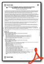
Weather Minimums
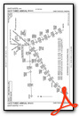
Standard Terminal Arrival (STAR) Charts
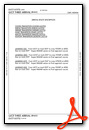
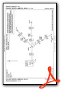
Instrument Approach Procedure (IAP) Charts


Nearby Airports with Instrument Procedures
| ID | Name | Heading / Distance | ||
|---|---|---|---|---|
 |
KGYY | Gary/Chicago International Airport | 353° | 5.9 |
|
KIGQ | Lansing Municipal Airport | 278° | 5.9 |
|
3HO | Hobart Sky Ranch Airport | 070° | 6.5 |
|
C56 | Bult Field Airport | 236° | 15.3 |
|
KVPZ | Porter County Regional Airport | 102° | 18.1 |
|
KMDW | Chicago Midway International Airport | 315° | 22.5 |
|
KMGC | Michigan City Municipal-Phillips Field Airport | 066° | 28.3 |
|
KPPO | La Porte Municipal Airport | 083° | 30.1 |
|
KLOT | Lewis University Airport | 279° | 31.8 |
|
KIKK | Greater Kankakee Airport | 217° | 33.6 |
|
1C5 | Bolingbrook's Clow International Airport | 288° | 34.5 |
|
KOXI | Starke County Airport | 108° | 35.1 |
Airport Images

By: 2flaps

By: BlakMyers


