Login
Register


C56
Bult Field Airport
Official FAA Data Effective 2026-01-22 0901Z
Chart Supplement

VFR Chart of C56
Sectional Charts at SkyVector.com
IFR Chart of C56
Enroute Charts at SkyVector.com
Location Information for C56
Coordinates: N41°22.65' / W87°40.78'Located 03 miles SE of Monee, Illinois on 130 acres of land. View all Airports in Illinois.
Surveyed Elevation is 790 feet MSL.
Operations Data
|
|
Airport Communications
| AWOS-AV: | 119.125 Tel. 708-534-5256 |
|---|---|
| CTAF: | 123.000 |
| UNICOM: | 123.000 |
| AWOS-3PT at IGQ (11.6 NE): | 124.925 708-889-6319 |
| D-ATIS at GYY (18.7 NE): | 134.575 |
| AWOS-3PT at GYY (18.7 NE): | 134.575 219-944-0010 |
- APCH/DEP SVC PRVDD BY CHICAGO ARTCC (ZAU) ON FREQS 132.5/284.7 (KANKAKEE RCAG).
Nearby Navigation Aids
|
| ||||||||||||||||||||||||||||||||||||||||||||||||||||||||||||


Runway 09/27
| Dimensions: | 5001 x 75 feet / 1524 x 23 meters | |
|---|---|---|
| Surface: | Concrete in Excellent Condition | |
| Weight Limits: | S-60 | |
| Edge Lighting: | Low Intensity | |
| Runway 09 | Runway 27 | |
| Coordinates: | N41°22.64' / W87°41.33' | N41°22.65' / W87°40.24' |
| Elevation: | 790.0 | 772.4 |
| Traffic Pattern: | Left | Left |
| Runway Heading: | 90° True | 270° True |
| Displaced Threshold: | 151 Feet | |
| Markings: | Non-Precision Instrument in fair condition. | Non-Precision Instrument in fair condition. |
| Obstacles: | RWY 27 12 FT ROAD 141 FT FM RWY END ON CL. |
50 ft Tree 1204 ft from runway, 300 ft left of center RWY 09 8 FT ROAD 156 FT RWY END CL. |
Services Available
| Fuel: | 100LL (blue), Jet-A |
|---|---|
| Transient Storage: | Hangars,Tiedowns |
| Airframe Repair: | NOT AVAILABLE |
| Engine Repair: | NOT AVAILABLE |
| Bottled Oxygen: | NOT AVAILABLE |
| Bulk Oxygen: | NOT AVAILABLE |
Ownership Information
| Ownership: | Publicly owned | |
|---|---|---|
| Owner: | IL DEPT OF TRANSPORTATION | |
| 1 LANGHORNE BOND DR. | ||
| SPRINGFIELD, IL 62702 | ||
| 708-534-8282 | ||
| Manager: | MARK THOMPSON | |
| 28261 SOUTH KEDZIE AVE | EMAIL ADDRESS: MTHOMPSON@BULTFIELD.COM (ALL LOWER CASE) | |
| MONEE, IL 60449 | ||
| (708) 534-8282 | ||
Other Remarks
- BIRDS AND ANIMALS ON AND INVOF OF ARPT.
- FOR CD CTC CHICAGO ARTCC AT 630-906-8921.
- CALM WND RWY.
- 0LL 100LL FUEL AVBL H24 W/CREDIT CARD.
- JET A AVBL AFT HR WITH PRIOR ARRANGEMENT.
Weather Minimums

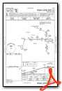
Instrument Approach Procedure (IAP) Charts

Nearby Airports with Instrument Procedures
| ID | Name | Heading / Distance | ||
|---|---|---|---|---|
 |
KIGQ | Lansing Municipal Airport | 035° | 11.6 |
|
05C | Griffith-Merrillville Airport | 055° | 15.3 |
|
KGYY | Gary/Chicago International Airport | 039° | 18.7 |
|
KIKK | Greater Kankakee Airport | 202° | 19.8 |
|
3HO | Hobart Sky Ranch Airport | 060° | 21.6 |
|
KLOT | Lewis University Airport | 306° | 23.3 |
|
KMDW | Chicago Midway International Airport | 352° | 24.7 |
|
1C5 | Bolingbrook's Clow International Airport | 313° | 27.8 |
|
KVPZ | Porter County Regional Airport | 081° | 30.7 |
|
C09 | Morris Municipal/James R Washburn Field Airport | 275° | 33.5 |
|
KRZL | Jasper County Airport | 138° | 34.2 |
|
KORD | Chicago O'Hare International Airport | 344° | 37.4 |
Airport Images

By: 2flaps

By: Bultfield1


