Login
Register
1C5
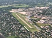
Bolingbrook's Clow International Airport
Official FAA Data Effective 2026-01-22 0901Z
VFR Chart of 1C5
Sectional Charts at SkyVector.com
IFR Chart of 1C5
Enroute Charts at SkyVector.com
Location Information for 1C5
Coordinates: N41°41.76' / W88°7.77'Located 00 miles NW of Bolingbrook, Illinois on 205 acres of land. View all Airports in Illinois.
Estimated Elevation is 674 feet MSL.
Operations Data
|
|
Airport Communications
| CHICAGO APPROACH: | 119.35 354.075 |
|---|---|
| CHICAGO DEPARTURE: | 119.35 354.075 |
| IC: | 119.35 |
| CTAF: | 122.900 |
| D-ATIS at LOT (5.5 S): | 126.675 |
| AWOS-3PT at LOT (5.7 S): | 126.675 815-588-4802 |
| AWOS-3 at JOT (10.9 S): | 119.975 815-730-9560 |
Nearby Navigation Aids
|
| ||||||||||||||||||||||||||||||||||||||||||||||||||||||||||||
Runway 18/36
| Dimensions: | 3360 x 75 feet / 1024 x 23 meters | |
|---|---|---|
| Surface: | Asphalt in Good Condition | |
| Weight Limits: | S-12 | |
| Edge Lighting: | Medium Intensity | |
| Runway 18 | Runway 36 | |
| Coordinates: | N41°42.03' / W88°7.78' | N41°41.48' / W88°7.76' |
| Elevation: | 674.9 | 657.0 |
| Traffic Pattern: | Left | Left |
| Runway Heading: | 178° True | 358° True |
| Markings: | Non-Precision Instrument in fair condition. | Non-Precision Instrument in fair condition. |
| Obstacles: | 34 ft Tree 697 ft from runway, 126 ft right of center | 25 ft Tree 600 ft from runway, 16 ft right of center |
Services Available
| Fuel: | 100LL (blue), Jet-A |
|---|---|
| Transient Storage: | Hangars,Tiedowns |
| Airframe Repair: | MAJOR |
| Engine Repair: | MAJOR |
| Bottled Oxygen: | NONE |
| Bulk Oxygen: | NONE |
| Other Services: | CHARTER SERVICE,PILOT INSTRUCTION,AIRCRAFT RENTAL,AIRCRAFT SALES |
Ownership Information
| Ownership: | Publicly owned | |
|---|---|---|
| Owner: | VILLAGE OF BOLINGBROOK | |
| 375 W BRIARCLIFF ROAD | ||
| BOLINGBROOK, IL 60440 | ||
| 630-226-8400 | ||
| Manager: | JOSEPH DE PAULO | |
| 130 S CLOW INTL PARKWAY | EMAIL ADDRESS: JOEDEPAULO@GMAIL.COM | |
| BOLINGBROOK, IL 60490 | ||
| 630-378-0479 | ||
Other Remarks
- TWY 20 FT WIDE; LARGE ACFT CONSIDER BACK-TAXI.
- NO TGL; FULL STOP LDG ONLY.
- FOR CD CTC CHICAGO APCH AT 847-289-0926.
- FLT SCHOOL OPS ONLY - 123.50.
- WILDLIFE ON AND INVOF ARPT.
- RESTAURANT ON ARPT.
- USE RWY 18 IN CALM WND OR DRCT CROSSWINDS.
- MIRL RY 18/36 PRESET LOW INTST DUSK-DAWN TO INCR INTST - CTAF
Weather Minimums
Instrument Approach Procedure (IAP) Charts
Nearby Airports with Instrument Procedures
| ID | Name | Heading / Distance | ||
|---|---|---|---|---|
 |
KLOT | Lewis University Airport | 164° | 5.5 |
 |
KDPA | Dupage Airport | 337° | 13.7 |
 |
KARR | Aurora Municipal Airport | 286° | 16.2 |
 |
KMDW | Chicago Midway International Airport | 072° | 17.8 |
 |
KORD | Chicago O'Hare International Airport | 030° | 19.6 |
 |
C09 | Morris Municipal/James R Washburn Field Airport | 218° | 20.8 |
 |
KPWK | Chicago Exec Airport | 022° | 27.1 |
 |
C56 | Bult Field Airport | 133° | 27.8 |
 |
KIGQ | Lansing Municipal Airport | 109° | 28.7 |
 |
KDKB | De Kalb Taylor Municipal Airport | 299° | 29.5 |
 |
3CK | Lake In The Hills Airport | 344° | 31.8 |
 |
KGYY | Gary/Chicago International Airport | 098° | 32.5 |


