Login
Register
0C2
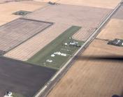
Hinckley Airport
Official FAA Data Effective 2026-01-22 0901Z
VFR Chart of 0C2
Sectional Charts at SkyVector.com
IFR Chart of 0C2
Enroute Charts at SkyVector.com
Location Information for 0C2
Coordinates: N41°46.25' / W88°42.20'Located 03 miles W of Hinckley, Illinois on 22 acres of land. View all Airports in Illinois.
Estimated Elevation is 760 feet MSL.
Operations Data
|
|
Airport Communications
| CTAF: | 122.900 |
|---|---|
| AWOS-3 at DKB (9.8 N): | 119.075 815-748-2350 |
| ATIS at ARR (10.2 E): | 125.85 |
| ASOS at ARR (10.2 E): | 630-466-5649 |
Nearby Navigation Aids
|
| ||||||||||||||||||||||||||||||||||||||||||||||||||||||
Runway 09/27
| Dimensions: | 2640 x 100 feet / 805 x 30 meters | |
|---|---|---|
| Surface: | Turf in Good Condition | |
| Runway 09 | Runway 27 | |
| Coordinates: | N41°46.25' / W88°42.50' | N41°46.25' / W88°41.92' |
| Elevation: | 760.0 | 755.0 |
| Traffic Pattern: | Left | Left |
| Markings: | None | None |
Services Available
| Fuel: | NONE |
|---|---|
| Transient Storage: | Tiedowns |
| Airframe Repair: | NOT AVAILABLE |
| Engine Repair: | NOT AVAILABLE |
| Bottled Oxygen: | NONE |
| Bulk Oxygen: | NONE |
| Other Services: | GLIDER SERVICE,PILOT INSTRUCTION,PARACHUTE JUMP ACTIVITY,GLIDER TOWING SERVICES |
Ownership Information
| Ownership: | Privately Owned | |
|---|---|---|
| Owner: | PARTNERS INVESTMENT CAP INC. | |
| 170 N MAY ST. | ||
| HINCKLEY, IL 60520 | ||
| 224-330-9990 | ||
| Manager: | JIM BEYER | |
| PO BOX 812 | ||
| HINCKLEY, IL 60520 | ||
| 316-213-7093 | ||
Other Remarks
- SOARING CONDUCTED AT ARPT.
- GLIDER OPNS SFC-17,500 FT.
- ARPT MAY BE UNUSBL UNDER VERY WET CONDS.
- RY 09/27 NOT PLOWED; USE AT OWN RISK.
- FOR CD CTC CHICAGO APCH AT 847-289-0926.
Nearby Airports with Instrument Procedures
| ID | Name | Heading / Distance | ||
|---|---|---|---|---|
 |
KDKB | De Kalb Taylor Municipal Airport | 359° | 9.8 |
 |
KARR | Aurora Municipal Airport | 089° | 10.2 |
 |
KRPJ | Rochelle Municipal/Koritz Field Airport | 293° | 18.4 |
 |
KDPA | Dupage Airport | 068° | 22.0 |
 |
C09 | Morris Municipal/James R Washburn Field Airport | 148° | 24.4 |
 |
1C5 | Bolingbrook's Clow International Airport | 099° | 26.2 |
 |
KLOT | Lewis University Airport | 109° | 29.0 |
 |
KRFD | Chicago/Rockford International Airport | 325° | 31.0 |
 |
3CK | Lake In The Hills Airport | 032° | 31.2 |
 |
KVYS | Illinois Valley Regional-Walter A Duncan Field Airport | 218° | 32.4 |
 |
C73 | Dixon Municipal-Charles R Walgreen Field Airport | 276° | 33.5 |
 |
C77 | Poplar Grove Airport | 349° | 33.6 |


