Login
Register


DPA
Dupage Airport
Official FAA Data Effective 2026-02-19 0901Z
Chart Supplement

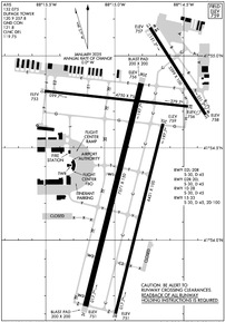
KDPA Airport Diagram
VFR Chart of KDPA
Sectional Charts at SkyVector.com
IFR Chart of KDPA
Enroute Charts at SkyVector.com
Location Information for KDPA
Coordinates: N41°54.42' / W88°14.88'Located 29 miles W of Chicago/West Chicago, Illinois on 2800 acres of land. View all Airports in Illinois.
Surveyed Elevation is 758 feet MSL.
Operations Data
|
|
Airport Communications
| ATIS: | 132.075 |
|---|---|
| ASOS: | Tel. 630-587-3668 |
| DUPAGE TOWER: | 120.9 124.5 257.8 |
| DUPAGE GROUND: | 121.8 |
| CHICAGO APPROACH: | 133.5 349.0 |
| CHICAGO DEPARTURE: | 133.5 349.0 |
| CLEARANCE DELIVERY: | 119.75 |
| UNICOM: | 122.950 |
| AWOS-3 at 06C (8.0 NE): | 128.275 (847) 895-2887 |
| ATIS at ARR (13.0 SW): | 125.85 |
| ASOS at ARR (13.0 SW): | 630-466-5649 |
Nearby Navigation Aids
|
| ||||||||||||||||||||||||||||||||||||||||||||||||||||||


Runway 02L/20R
| Dimensions: | 7571 x 150 feet / 2308 x 46 meters | |
|---|---|---|
| Surface: | Concrete / Grooved in Good Condition | |
| Weight Limits: | S-30, D-45 | |
| Edge Lighting: | High Intensity | |
| Runway 02L | Runway 20R | |
| Coordinates: | N41°53.64' / W88°15.21' | N41°54.85' / W88°14.81' |
| Elevation: | 750.8 | 755.5 |
| Runway Heading: | 14° True | 194° True |
| Markings: | Precision Instrument in good condition. | Precision Instrument in good condition. |
| Glide Slope Indicator | P4L (3.00° Glide Path Angle) | |
| RVR Equipment | Touchdown | Rollout |
| Approach Lights: | MALSR 1,400 Foot Medium-intensity Approach Lighting System with runway alignment indicator lights. | |
| Centerline Lights: | Yes | Yes |
Runway 02R/20L
| Dimensions: | 6451 x 100 feet / 1966 x 30 meters | |
|---|---|---|
| Surface: | Concrete / Grooved in Good Condition | |
| Weight Limits: | S-30, D-45 | |
| Edge Lighting: | Medium Intensity | |
| Runway 02R | Runway 20L | |
| Coordinates: | N41°53.60' / W88°15.00' | N41°54.63' / W88°14.65' |
| Elevation: | 750.5 | 758.5 |
| Traffic Pattern: | Right | |
| Runway Heading: | 14° True | 194° True |
| Markings: | Non-Precision Instrument in good condition. | Non-Precision Instrument in good condition. |
Runway 10/28
| Dimensions: | 4750 x 75 feet / 1448 x 23 meters | |
|---|---|---|
| Surface: | Asphalt / Grooved in Good Condition | |
| Weight Limits: | S-30, D-45 | |
| Edge Lighting: | High Intensity | |
| Runway 10 | Runway 28 | |
| Coordinates: | N41°54.81' / W88°15.51' | N41°54.73' / W88°14.47' |
| Elevation: | 753.3 | 755.9 |
| Traffic Pattern: | Left | Left |
| Runway Heading: | 96° True | 276° True |
| Markings: | Precision Instrument in good condition. | Precision Instrument in good condition. |
| Glide Slope Indicator | V4L (3.00° Glide Path Angle) UNUSBL BYD 5 DEG RIGHT AND LEFT OF CNTRLN. | P4L (3.00° Glide Path Angle) |
| Approach Lights: | RLLS RLLS | |
| REIL: | Yes | Yes |
| Obstacles: | 34 ft Building 1743 ft from runway | |
Runway 15/33
| Dimensions: | 3399 x 100 feet / 1036 x 30 meters | |
|---|---|---|
| Surface: | Asphalt in Good Condition | |
| Weight Limits: | S-30, D-45, ST-100 | |
| Edge Lighting: | Medium Intensity | |
| Runway 15 | Runway 33 | |
| Coordinates: | N41°55.15' / W88°14.74' | N41°54.68' / W88°14.34' |
| Elevation: | 756.9 | 757.6 |
| Traffic Pattern: | Left | Left |
| Runway Heading: | 148° True | 328° True |
| Displaced Threshold: | 190 Feet | |
| Markings: | Basic in good condition. | Basic in good condition. |
| Glide Slope Indicator | P4R (3.90° Glide Path Angle) | |
| REIL: | Yes | Yes |
| Obstacles: | 91 ft Tree 1750 ft from runway, 205 ft right of center | 55 ft Tree 893 ft from runway, 183 ft left of center APCH RATIO IS 20:1 TO DSPLCD THLD. +13 FT ROAD 199 FT FM RY END 125 FT R. |
Services Available
| Fuel: | 100LL (blue), Jet-A |
|---|---|
| Transient Storage: | Hangars,Tiedowns |
| Airframe Repair: | MAJOR |
| Engine Repair: | MAJOR |
| Bottled Oxygen: | HIGH/LOW |
| Bulk Oxygen: | HIGH/LOW |
| Other Services: | AIR FREIGHT SERVICES,AVIONICS,CARGO HANDLING SERVICES,CHARTER SERVICE,PILOT INSTRUCTION,AIRCRAFT RENTAL,AIRCRAFT SALES |
Ownership Information
| Ownership: | Publicly owned | |
|---|---|---|
| Owner: | DUPAGE ARPT AUTH | |
| 2700 INTERNATIONAL DRIVE STE 200 | ||
| WEST CHICAGO, IL 60185-0787 | ||
| 630-584-2211 | ||
| Manager: | MARK DOLES | |
| 2700 INT'L DRIVE, STE 200 | EMAIL ADDRESS: DBIRD@DUPAGEAIRPORT.GOV (ALL LOWER CASE) | |
| WEST CHICAGO, IL 60185-0787 | ||
| 630-584-2211 | ||
Other Remarks
- DEER, COYOTE, BIRDS & MIGRATORY WATERFOWL ON & INVOF ARPT.
- ACFT ON SHORT FINAL TO RY 15 ARE NOT VSB FROM ATCT DUE TO TREES.
- ARFF INDEX B PPR
- US CUST SVC AVBL PPR.
- INT DEP RWY 20R AT TWY G HAS 6141'.
- 0LL 100LL SELF SER AVBL 24HR WITH CREDIT CARD.
- ATC-CTL
Weather Minimums


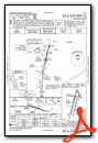
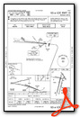
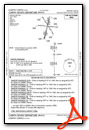
Instrument Approach Procedure (IAP) Charts

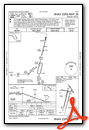


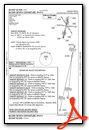
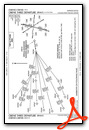
Departure Procedure (DP) Charts


Nearby Airports with Instrument Procedures
| ID | Name | Heading / Distance | ||
|---|---|---|---|---|
 |
KARR | Aurora Municipal Airport | 231° | 13.0 |
|
1C5 | Bolingbrook's Clow International Airport | 157° | 13.7 |
|
KORD | Chicago O'Hare International Airport | 074° | 15.8 |
|
3CK | Lake In The Hills Airport | 349° | 18.3 |
|
KLOT | Lewis University Airport | 159° | 19.2 |
|
KPWK | Chicago Exec Airport | 051° | 19.9 |
|
KDKB | De Kalb Taylor Municipal Airport | 274° | 20.6 |
|
KMDW | Chicago Midway International Airport | 107° | 23.4 |
|
C81 | Campbell Airport | 017° | 26.2 |
|
C09 | Morris Municipal/James R Washburn Field Airport | 194° | 29.9 |
|
10C | Galt Field Airport | 349° | 30.3 |
|
KUGN | Waukegan Ntl Airport | 028° | 35.2 |

 from the south")


