Login
Register


ARR
Aurora Municipal Airport
Official FAA Data Effective 2026-02-19 0901Z
From the Flight Deck
Chart Supplement

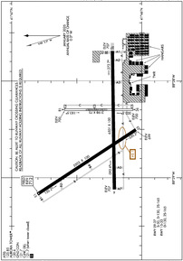
KARR Airport Diagram
VFR Chart of KARR
Sectional Charts at SkyVector.com
IFR Chart of KARR
Enroute Charts at SkyVector.com
Location Information for KARR
Coordinates: N41°46.32' / W88°28.54'Located 38 miles W of Chicago/Aurora, Illinois on 1100 acres of land. View all Airports in Illinois.
Surveyed Elevation is 712 feet MSL.
Operations Data
|
|
Airport Communications
| ATIS: | 125.85 |
|---|---|
| ASOS: | Tel. 630-466-5649 |
| AURORA TOWER: | 120.6 |
| AURORA GROUND: | 121.7 |
| CHICAGO APPROACH: | 133.5 349.0 |
| CHICAGO DEPARTURE: | 133.5 349.0 |
| CLEARANCE DELIVERY: | 121.7 ;WHEN AURORA TWR CLSD |
| CTAF: | 120.600 |
| ASOS at DPA (13.0 NE): | 630-587-3668 |
| ATIS at DPA (13.0 NE): | 132.075 |
| AWOS-3 at DKB (14.2 NW): | 119.075 815-748-2350 |
- EMERG FREQ 121.5 NOT AVBL AT TWR.
Nearby Navigation Aids
|
| ||||||||||||||||||||||||||||||||||||||||||||||||||||||


Runway 09/27
| Dimensions: | 6501 x 100 feet / 1982 x 30 meters | |
|---|---|---|
| Surface: | Concrete / Grooved in Good Condition | |
| Weight Limits: | S-30, D-130 | |
| Edge Lighting: | High Intensity | |
| Runway 09 | Runway 27 | |
| Coordinates: | N41°46.21' / W88°29.12' | N41°46.23' / W88°27.69' |
| Elevation: | 706.8 | 707.2 |
| Traffic Pattern: | Left | |
| Runway Heading: | 89° True | 269° True |
| Declared Distances: | ASDA:6972 | ASDA:6460 LDA:6460 |
| Markings: | Precision Instrument in good condition. | Precision Instrument in good condition. |
| Glide Slope Indicator | P4L (3.00° Glide Path Angle) | P4L (3.00° Glide Path Angle) |
| Approach Lights: | MALSR 1,400 Foot Medium-intensity Approach Lighting System with runway alignment indicator lights. | |
| REIL: | Yes | |
Runway 15/33
| Dimensions: | 5503 x 100 feet / 1677 x 30 meters | |
|---|---|---|
| Surface: | Concrete / Grooved in Good Condition | |
| Weight Limits: | D-130 | |
| Edge Lighting: | High Intensity | |
| Runway 15 | Runway 33 | |
| Coordinates: | N41°46.80' / W88°29.17' | N41°46.04' / W88°28.50' |
| Elevation: | 712.0 | 698.5 |
| Runway Heading: | 147° True | 327° True |
| Markings: | Precision Instrument in good condition. | Precision Instrument in good condition. |
| Glide Slope Indicator | P4L (3.00° Glide Path Angle) | P4L (3.00° Glide Path Angle) |
| Approach Lights: | MALSR 1,400 Foot Medium-intensity Approach Lighting System with runway alignment indicator lights. | |
| REIL: | Yes | |
| Obstacles: | 44 ft Tree 1039 ft from runway, 540 ft left of center | 88 ft Tree 3503 ft from runway, 924 ft left of center |
Runway 18/36
| Dimensions: | 3198 x 75 feet / 975 x 23 meters | |
|---|---|---|
| Surface: | Asphalt in Poor Condition SEVERAL LARGE CRACKS & VEGETATIVE GROWTH. | |
| Weight Limits: | S-30 | |
| Edge Lighting: | Medium Intensity | |
| Runway 18 | Runway 36 | |
| Coordinates: | N41°46.59' / W88°28.30' | N41°46.07' / W88°28.30' |
| Elevation: | 700.1 | 700.4 |
| Traffic Pattern: | Left | |
| Runway Heading: | 180° True | 360° True |
| Markings: | Basic in fair condition. | Non-Precision Instrument in fair condition. |
| Glide Slope Indicator | P4L (3.00° Glide Path Angle) | V4L (3.00° Glide Path Angle) |
| REIL: | Yes | Yes |
| Obstacles: | 39 ft Pole 1129 ft from runway, 296 ft right of center RISING GROUND +6 FEET. |
73 ft Tree 3140 ft from runway, 497 ft right of center |
Services Available
| Fuel: | 100 (green), Jet A-1 |
|---|---|
| Transient Storage: | Hangars,Tiedowns |
| Airframe Repair: | MAJOR |
| Engine Repair: | MAJOR |
| Bottled Oxygen: | HIGH/LOW |
| Bulk Oxygen: | HIGH/LOW |
| Other Services: | AIR FREIGHT SERVICES,AVIONICS,CARGO HANDLING SERVICES,CHARTER SERVICE,PILOT INSTRUCTION,AIRCRAFT RENTAL,AIRCRAFT SALES |
Ownership Information
| Ownership: | Publicly owned | |
|---|---|---|
| Owner: | CITY OF AURORA | |
| 44 E. DOWNER PLACE | ||
| AURORA, IL 60507 | ||
| (630) 256-3120 | ||
| Manager: | STEVE ANDRAS | |
| 43W 636 US30 | ||
| SUGAR GROVE, IL 60554 | ||
| (630) 256-3120 | ||
Other Remarks
- SEASONAL CROPS IN PART 77 SURFACES RUNWAY 9/27 & 15/33
- ACTVT MALSR RWY 09, 33; REIL RWY 18, 36,15, 27; TWY LGTS - CTAF. WHEN ATCT CLSD HIRL RWY 15/33, 09/27; MIRL RWY 18/36 PRESET LOW INTST, TO INCR INTST & ACTVT - CTAF.
- FBO SVCS ON FREQ 122.95 AND 123.50.
Weather Minimums


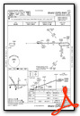
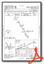
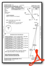
Instrument Approach Procedure (IAP) Charts


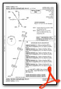
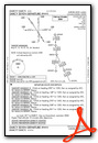
Departure Procedure (DP) Charts


Nearby Airports with Instrument Procedures
| ID | Name | Heading / Distance | ||
|---|---|---|---|---|
 |
KDPA | Dupage Airport | 051° | 13.0 |
|
KDKB | De Kalb Taylor Municipal Airport | 313° | 14.2 |
|
1C5 | Bolingbrook's Clow International Airport | 106° | 16.2 |
|
KLOT | Lewis University Airport | 119° | 19.7 |
|
C09 | Morris Municipal/James R Washburn Field Airport | 172° | 21.0 |
|
3CK | Lake In The Hills Airport | 014° | 27.0 |
|
KRPJ | Rochelle Municipal/Koritz Field Airport | 285° | 28.0 |
|
KORD | Chicago O'Hare International Airport | 064° | 28.3 |
|
KMDW | Chicago Midway International Airport | 088° | 32.5 |
|
KPWK | Chicago Exec Airport | 051° | 32.9 |
|
C77 | Poplar Grove Airport | 334° | 36.8 |
|
KRFD | Chicago/Rockford International Airport | 312° | 37.7 |
Fuel Providers

Airport Images
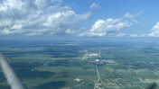
By: Bgarbs12

By: paxcal777


