Login
Register


14VA
Krens Farm Airport
Official FAA Data Effective 2026-02-19 0901Z
VFR Chart of 14VA
Sectional Charts at SkyVector.com
IFR Chart of 14VA
Enroute Charts at SkyVector.com
Location Information for 14VA
Coordinates: N39°13.74' / W77°44.80'Located 02 miles NW of Hillsboro, Virginia on 48 acres of land. View all Airports in Virginia.
Estimated Elevation is 790 feet MSL.
Operations Data
|
|
Airport Communications
| AWOS-3 at JYO (12.6 SE): | 125.225 703-777-3781 |
|---|---|
| ASOS at MRB (14.9 NW): | 119.925 304-264-0988 |
| AWOS-3 at OKV (19.2 W): | 124.85 540-662-6970 |
Nearby Navigation Aids
|
| ||||||||||||||||||||||||||||||||||||||||||||||||||||||||||||


Runway 01/19
| Dimensions: | 1900 x 50 feet / 579 x 15 meters | |
|---|---|---|
| Surface: | Turf | |
| Runway 01 | Runway 19 | |
Ownership Information
| Ownership: | Privately Owned | |
|---|---|---|
| Owner: | JANET KRENS | |
| PO BOX 844 | ||
| PURCELLVILLE, VA 22132 | ||
| 703-668-6937 | ||
| Manager: | RICK KRENS | |
| 509 CANTERBURY CIR | ||
| PURCELLVILLE, VA 20132 | ||
| 540-338-7071 | ||
Other Remarks
- FOR CD CTC POTOMAC APCH AT 866-709-4993.
- WILDLIFE AND HORSES IN AREA
Nearby Airports with Instrument Procedures
| ID | Name | Heading / Distance | ||
|---|---|---|---|---|
 |
KJYO | Leesburg Exec Airport | 135° | 12.6 |
|
KMRB | Eastern Wv Regional/Shepherd Field Airport | 313° | 15.1 |
|
KOKV | Winchester Regional Airport | 254° | 19.3 |
|
KFDK | Frederick Municipal Airport | 056° | 20.7 |
|
KIAD | Washington Dulles International Airport | 141° | 21.5 |
|
KGAI | Montgomery County Airpark Airport | 097° | 27.3 |
|
W50 | Davis Airport | 088° | 27.8 |
|
KHGR | Hagerstown Regional/Richard A Henson Field Airport | 001° | 28.8 |
|
KFRR | Front Royal-Warren County Airport | 231° | 30.2 |
|
KHEF | Manassas Regional/Harry P Davis Field Airport | 160° | 32.3 |
|
W35 | Potomac Airpark Airport | 325° | 33.9 |
|
2W2 | Clearview Airpark Airport | 066° | 36.8 |
Airport Images
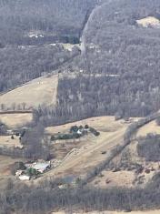
By: Big Orange Bird


