
Login
Register


19S
Sublette Municipal Airport
Official FAA Data Effective 2024-08-08 0901Z
Chart Supplement
VFR Chart of 19S
Sectional Charts at SkyVector.com
IFR Chart of 19S
Enroute Charts at SkyVector.com
Location Information for 19S
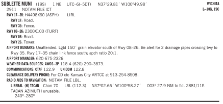
Coordinates: N37°29.81' / W100°49.98'Located 01 miles NE of Sublette, Kansas on 18 acres of land. View all Airports in Kansas.
Surveyed Elevation is 2910 feet MSL.
Operations Data
|
|
Airport Communications
| AWOS-3P: | 118.4 Tel. 620-290-3873 |
|---|---|
| UNICOM: | 122.800 |
| CTAF: | 122.900 |
| AWOS-3PT at MEJ (26.2 SE): | 119.425 620-518-2544 |
| ASOS at GCK (26.4 N): | 121.325 620-275-0803 |
| AWOS-3PT at ULS (26.7 W): | 118.95 620-424-3747 |
Nearby Navigation Aids
|
| ||||||||||||||||||||||||||||||||||||||||||||||||||||||


Runway 17/35
| Dimensions: | 4498 x 60 feet / 1371 x 18 meters | |
|---|---|---|
| Surface: | Asphalt in Good Condition | |
| Edge Lighting: | Low Intensity | |
| Runway 17 | Runway 35 | |
| Coordinates: | N37°30.19' / W100°50.06' | N37°29.45' / W100°50.06' |
| Elevation: | 2909.5 | 2907.1 |
| Traffic Pattern: | Left | Left |
| Markings: | Basic in fair condition. | Basic in fair condition. |
| Obstacles: | 0 ft Road 250 ft from runway ROAD AT 250 FT FROM THLD. |
15 ft Fence 200 ft from runway CHAIN LINK FENCE SOUTH; APCH RATIO 20:1. ROAD AT 100' FROM THR. |
Runway 08/26
| Dimensions: | 2300 x 100 feet / 701 x 30 meters | |
|---|---|---|
| Surface: | Turf in Fair Condition | |
| Runway 08 | Runway 26 | |
| Coordinates: | N37°29.80' / W100°50.05' | N37°29.79' / W100°49.58' |
| Elevation: | 2908.7 | 2910.6 |
| Traffic Pattern: | Left | Left |
| Markings: | in fair condition. | in fair condition. |
| Obstacles: | 0 ft Road 165 ft from runway RY 17/35 AT 35 FT FM END. |
10 ft Tower 130 ft from runway |
Services Available
| Fuel: | NONE |
|---|---|
| Transient Storage: | Tiedowns 2 SETS |
| Airframe Repair: | NONE |
| Engine Repair: | NONE |
| Bottled Oxygen: | NONE |
| Bulk Oxygen: | NONE |
Ownership Information
| Ownership: | Publicly owned | |
|---|---|---|
| Owner: | CITY OF SUBLETTE | |
| BOX 934 | ||
| SUBLETTE, KS 67877 | ||
| 620-675-2326 | ||
| Manager: | DAYLEN ELSEY | |
| BOX 934 | ||
| SUBLETTE, KS 67877 | ||
| 620-675-2326 | ||
Operational Statistics
| Single Engine Aircraft Based on Field: | 3 | Statistics collected for 12 month period ending 2021-08-27 | |
|---|---|---|---|
| Multi-Engine Aircraft Based on Field: | none | Annual Commercial Operations: | none |
| Jet Aircraft Based on Field: | none | Annual Commuter Operations: | none |
| Helicopters Based on Field: | none | Annual Air Taxi Operations: | none |
| Military Aircraft Based on Field: | none | Annual Military Operations: | none |
| Gliders Based on Field: | none | Annual GA Local Operations: | 300 |
| Ultralights Based on Field: | none | Annual GA Itinerant Operations: | 300 |
Other Remarks
- LGTD 150' GRAIN ELEVATOR SOUTH OF RWY 08/26.
- BE ALERT FOR 2 DRAINAGE PIPES CROSSING TWY TO RY 35.
- FOR CD CTC KANSAS CITY ARTCC AT 913-254-8508.
- NSTD THLD BAR (TOO NARROW).
Nearby Airports with Instrument Procedures
| ID | Name | Heading / Distance | ||
|---|---|---|---|---|
 |
KMEJ | Meade Municipal Airport | 119° | 26.3 |
|
KGCK | Garden City Regional Airport | 011° | 26.3 |
|
KULS | Ulysses Airport | 284° | 26.6 |
|
KLBL | Liberal Mid-America Regional Airport | 192° | 27.8 |
|
KHQG | Hugoton Municipal Airport | 232° | 32.6 |
|
KJHN | Stanton County Municipal Airport | 277° | 43.2 |
|
KDDC | Dodge City Regional Airport | 068° | 44.3 |
|
3K3 | Syracuse-Hamilton County Municipal Airport | 304° | 52.9 |
|
K79 | Jetmore Municipal Airport | 056° | 53.4 |
|
KEHA | Elkhart-Morton County Airport | 239° | 58.3 |
|
KGUY | Guymon Municipal Airport | 213° | 58.5 |
|
KTQK | Scott City Municipal Airport | 357° | 58.7 |
Airport Images
Do you have a recent image of this airport? Upload it here!



Comments
PROBLEM: the fuel pump DID NOT work
I flew my Skyhawk into Sublette Airport. I stopped there because their fuel was listed in Foreflight as being the cheapest around.
PROBLEM: the fuel pump DID NOT work. I could not buy gas there.
I emailed the manager DILLON SHOTTON, but received NO REPLY.
I informed Foreflight. They also tried to contact the airport. They received NO REPLY>
THis could be a hazardous situation if you fly here with low fuel, intending to fill up on cheap gas. What would you do when you realize the pumps ae inop? take off with almost no fuel on-board...?
Rock Mathias