Login
Register


CGF
Cuyahoga County Airport
Official FAA Data Effective 2026-01-22 0901Z
Chart Supplement

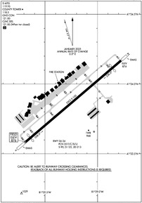
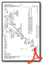
KCGF Airport Diagram
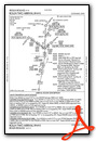
VFR Chart of KCGF
Sectional Charts at SkyVector.com
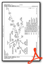
IFR Chart of KCGF
Enroute Charts at SkyVector.com
Location Information for KCGF
Coordinates: N41°33.87' / W81°29.23'Located 10 miles E of Cleveland, Ohio on 640 acres of land. View all Airports in Ohio.
Surveyed Elevation is 876 feet MSL.
Operations Data
|
|
Airport Communications
| D-ATIS: | 119.95 (216-998-7640) |
|---|---|
| AWOS-3PT: | Tel. 216-998-7640 |
| COUNTY TOWER: | 118.5 |
| COUNTY GROUND: | 121.85 |
| CLEVELAND APPROACH: | 125.35 346.325 |
| CLEVELAND DEPARTURE: | 125.35 346.325 |
| CLEARANCE DELIVERY: | 121.85 ;WHEN TWR CLSD |
| TRYBE STAR: | 126.55 |
| ROLLN STAR: | 126.55 |
| ROKNN STAR: | 126.55 |
| CTAF: | 118.500 |
| BRWNZ STAR: | 126.55 |
| AWOS-3PT at LNN (8.4 NE): | 119.225 440-942-0809 |
| ATIS at BKL (9.2 W): | 125.25 |
| ASOS at BKL (9.3 W): | 216-241-6904 |
- ATCT IS CONTRACTED.
- EMRG FREQ 121.5 UNMONITORED.
Nearby Navigation Aids
|
| ||||||||||||||||||||||||||||||||||||||||||||||||||||||||||||


Runway 06/24
| Dimensions: | 5502 x 100 feet / 1677 x 30 meters | |
|---|---|---|
| Surface: | Asphalt / Grooved in Good Condition | |
| Weight Limits: | 35 /F/C/X/U, S-90, D-123, ST-213 | |
| Edge Lighting: | High Intensity | |
| Runway 06 | Runway 24 | |
| Coordinates: | N41°33.58' / W81°29.69' | N41°34.17' / W81°28.77' |
| Elevation: | 876.1 | 874.0 |
| Traffic Pattern: | Left | Left |
| Runway Heading: | 49° True | 229° True |
| Displaced Threshold: | 318 Feet | 500 Feet |
| Declared Distances: | TORA:5502 TODA:5502 ASDA:5502 LDA:5184 | TORA:5502 TODA:5502 ASDA:5502 LDA:5000 |
| Markings: | Non-Precision Instrument in good condition. | Precision Instrument in good condition. |
| Glide Slope Indicator | P4L (3.00° Glide Path Angle) | P4L (3.00° Glide Path Angle) |
| Approach Lights: | MALSR 1,400 Foot Medium-intensity Approach Lighting System with runway alignment indicator lights. | |
| REIL: | Yes | |
| Obstacles: | 86 ft Tree 1769 ft from runway, 336 ft right of center 7 FT ROAD, 703 FT DIST, 325 FT L. APCH SLP 24:1 TO DTHR 86 FT TREES, 2087 FT DIST, 336 FT R. |
7 ft Road 201 ft from runway, 325 ft left of center APCH SLP 50:1 TO DTHR. 7 FT ROAD, 0 FT DIST, 525 FT L; 2 FT FENCE, 0 FT DIST, 500 FT L. |
Services Available
| Fuel: | 100LL (blue), Jet-A, Jet A+ |
|---|---|
| Transient Storage: | Hangars,Tiedowns |
| Airframe Repair: | MAJOR |
| Engine Repair: | MAJOR |
| Bottled Oxygen: | HIGH |
| Bulk Oxygen: | NONE |
| Other Services: | AIR FREIGHT SERVICES,AVIONICS,CHARTER SERVICE,PILOT INSTRUCTION,AIRCRAFT RENTAL,AIRCRAFT SALES |
Ownership Information
| Ownership: | Publicly owned | |
|---|---|---|
| Owner: | CUYAHOGA COUNTY | |
| 26300 CURTISS WRIGHT PKWY | ||
| RICHMOND HEIGHTS, OH 44143-4408 | ||
| 216-289-4111 | ||
| Manager: | J MYERS | CCAIRPORT@CUYAHOGACOUNTY.US. |
| 26300 CURTISS WRIGHT PKWY | ||
| RICHMOND HEIGHTS, OH 44143-4408 | ||
| 216-289-4111 | ||
Other Remarks
- NOISE ABATEMENT PROCS IN EFCT CALL ARPT.
- FOR CD WHEN ATCT CLSD CTC CLEVELAND APCH AT 216-352-2323.
- BIRDS & WILDLIFE ON & INVOF ARPT.
- ATCT VIS SW LTD WI 500 FT AER 06.
- FLT TRG PROHIBITED 2300-0700.
- WHEN ATCT CLSD ACTVT WINDSOCKS; MALSR RWY 24; REIL RWY 06; PAPI RWY 06; HIRL RWY 06/24 - CTAF. PAPI RWY 24 OPR CONSLY.
Weather Minimums


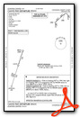
Standard Terminal Arrival (STAR) Charts
Instrument Approach Procedure (IAP) Charts

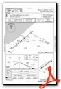

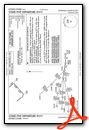
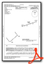
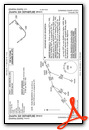
Departure Procedure (DP) Charts

Nearby Airports with Instrument Procedures
| ID | Name | Heading / Distance | ||
|---|---|---|---|---|
 |
KLNN | Lake County Exec Airport | 031° | 8.4 |
|
KBKL | Burke Lakefront Airport | 252° | 9.2 |
|
2G1 | Concord Airpark Airport | 064° | 14.4 |
|
KCLE | Cleveland-Hopkins International Airport | 240° | 19.0 |
|
7G8 | Geauga County Airport | 109° | 20.3 |
|
KPOV | Portage County Airport | 153° | 23.8 |
|
1G3 | Kent State University Airport | 172° | 25.0 |
|
1G5 | Medina Municipal Airport | 205° | 28.8 |
|
1G1 | Elyria Airport | 243° | 31.0 |
|
KAKR | Akron Fulton International Airport | 178° | 31.6 |
|
KLPR | Lorain County Regional Airport | 247° | 33.8 |
|
3G3 | Wadsworth Municipal Airport | 199° | 35.8 |
Airport Images

By: btracy62


