



Login
Register
LPR
Lorain County Regional Airport
Official FAA Data Effective 2026-10-01 0901Z
Chart Supplement

VFR Chart of KLPR
Sectional Charts at SkyVector.com
IFR Chart of KLPR
Enroute Charts at SkyVector.com
Location Information for KLPR
Coordinates: N41°20.66' / W82°10.66'Located 06 miles S of Lorain/Elyria, Ohio on 1149 acres of land. View all Airports in Ohio.
Surveyed Elevation is 793 feet MSL.
Operations Data
|
|
Airport Communications
| ASOS: | 118.925 Tel. 440-323-7088 |
|---|---|
| CLEVELAND APPROACH: | 125.35 346.325 |
| CLEVELAND DEPARTURE: | 125.35 346.325 |
| CLEARANCE DELIVERY: | 125.7 |
| ROLLN STAR: | 126.55 |
| BRWNZ STAR: | 126.55 |
| CTAF: | 122.700 |
| UNICOM: | 122.700 |
| ROKNN STAR: | 126.55 |
| D-ATIS at CLE (15.1 E): | 127.85 ;ARR |
| ASOS at CLE (15.1 E): | 216-264-9022 |
| ASOS at BKL (24.6 NE): | 216-241-6904 |
Nearby Navigation Aids
|
| ||||||||||||||||||||||||||||||||||||||||||||||||||||||||||||


Runway 07/25
| Dimensions: | 5002 x 100 feet / 1525 x 30 meters | |
|---|---|---|
| Surface: | Asphalt / Grooved in Good Condition | |
| Weight Limits: | S-80, D-110, ST-180 | |
| Edge Lighting: | High Intensity | |
| Runway 07 | Runway 25 | |
| Coordinates: | N41°20.48' / W82°11.15' | N41°20.83' / W82°10.16' |
| Elevation: | 793.2 | 787.3 |
| Traffic Pattern: | Left | Right |
| Runway Heading: | 65° True | 245° True |
| Markings: | Precision Instrument in good condition. | Non-Precision Instrument in good condition. |
| Glide Slope Indicator | P4L (3.00° Glide Path Angle) | P4L (3.00° Glide Path Angle) |
| Approach Lights: | MALSR 1,400 Foot Medium-intensity Approach Lighting System with runway alignment indicator lights. | |
| REIL: | Yes | |
| Obstacles: | 45 ft Tree 1932 ft from runway, 730 ft left of center | |
Services Available
| Fuel: | 100LL (blue), Jet-A |
|---|---|
| Transient Storage: | Hangars,Tiedowns PPR FOR TSNT HNGR STORAGE. |
| Airframe Repair: | MAJOR |
| Engine Repair: | MAJOR |
| Bottled Oxygen: | NONE |
| Bulk Oxygen: | HIGH/LOW |
| Other Services: | AIR AMBULANCE SERVICES,AVIONICS,CARGO HANDLING SERVICES,CHARTER SERVICE,PILOT INSTRUCTION,AIRCRAFT RENTAL,AIRCRAFT SALES |
Ownership Information
| Ownership: | Publicly owned | |
|---|---|---|
| Owner: | LORAIN CO BOARD OF COMMISSIONERS | |
| 44050 RUSSIA RD | ||
| ELYRIA, OH 44035-6800 | ||
| 440-329-5000 | ||
| Manager: | DOUG MCCONNELL | |
| C/O MRK AVIATION, 44050 RUSSIA RD | ||
| ELYRIA, OH 44035-6800 | ||
| 440-323-7000 | CELL: 216-389-6042 OR 330-721-8142. | |
Other Remarks
- PILOTS OPERG IN OBERLIN AREA REQD TO AVOID & RMN WELL CLR OF OBERLIN COLLEGE DUE TO MUSIC CONSERVATORY; ALL TFC OPNS NORTH OF ARPT AS PER FAR PART 93 SUBPART J.
- DEER, BIRDS, & OTR WILDLIFE ON & INVOF ARPT.
- FOR CD CTC CLEVELAND APCH AT 216-352-2323.
- ACTVT OR INCR INTST MALSR RWY 07; REIL RWY 25; HIRL RWY 07/25 - CTAF. PAPI RWY 07 & 25 OPR CONSLY; HIRL RWY 07/25 PRESET LOW INTST.
Weather Minimums


Standard Terminal Arrival (STAR) Charts


Instrument Approach Procedure (IAP) Charts


Departure Procedure (DP) Charts


Nearby Airports with Instrument Procedures
| ID | Name | Heading / Distance | ||
|---|---|---|---|---|
 |
1G1 | Elyria Airport | 102° | 3.6 |
|
KCLE | Cleveland-Hopkins International Airport | 074° | 15.1 |
|
5A1 | Norwalk/Huron County Airport | 250° | 17.9 |
|
1G5 | Medina Municipal Airport | 124° | 22.6 |
|
KBKL | Burke Lakefront Airport | 064° | 24.6 |
|
3G4 | Ashland County Airport | 187° | 26.7 |
|
3G3 | Wadsworth Municipal Airport | 136° | 28.0 |
|
8G1 | Willard Airport | 233° | 30.8 |
|
KBJJ | Wayne County Airport | 154° | 31.1 |
|
KPCW | Erie-Ottawa International Airport | 288° | 32.9 |
|
KCGF | Cuyahoga County Airport | 066° | 33.8 |
|
KMFD | Mansfield Lahm Regional Airport | 206° | 34.9 |
Airport Images
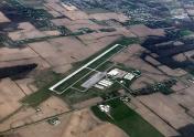
By: flight2000



