Login
Register


1T7
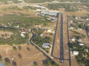
Kestrel Airpark Airport
Official FAA Data Effective 2025-11-27 0901Z
Chart Supplement

VFR Chart of 1T7
Sectional Charts at SkyVector.com
IFR Chart of 1T7
Enroute Charts at SkyVector.com
Location Information for 1T7
Coordinates: N29°48.70' / W98°25.56'Located 23 miles N of San Antonio, Texas on 25 acres of land. View all Airports in Texas.
Estimated Elevation is 1261 feet MSL.
Operations Data
|
|
Airport Communications
| CTAF: | 122.975 |
|---|---|
| UNICOM: | 122.975 |
| AWOS-3 at 5C1 (15.0 W): | 118.725 830-755-9099 |
| D-ATIS at SAT (16.8 S): | 118.9 |
| ASOS at SAT (16.9 S): | 210-939-4003 |
Nearby Navigation Aids
|
| ||||||||||||||||||||||||||||||||||||||||||||||||||||||||||||


Runway 12/30
RWY 30 RISES RAPIDLY AT NORTH END. 12 END 49 FT HIGHER THAN 30 END. | ||
| Dimensions: | 3000 x 40 feet / 914 x 12 meters | |
|---|---|---|
| Surface: | Asphalt in Good Condition | |
| Edge Lighting: | Non-Standard RWY LGTS NOT AT THRS - 2780 FT AVBL NGTS. | |
| Runway 12 | Runway 30 | |
| Coordinates: | N29°48.86' / W98°25.79' | N29°48.55' / W98°25.34' |
| Elevation: | 1261.0 | 1218.0 |
| Traffic Pattern: | Right | |
| Runway Heading: | 128° True | 308° True |
| Markings: | Basic in good condition. | Basic in good condition. |
| Obstacles: | 15 ft Trees 300 ft from runway, 30 ft left of center 15 FT RD 0 FT DSTC 65 FT L; 30 FT TREE 80 FT DSTC, 45 FT L. |
15 ft Road 200 ft from runway 15 FT RD 0 FT DSTC 67 FT L. |
Services Available
| Fuel: | 100LL (blue) |
|---|---|
| Transient Storage: | Tiedowns |
| Airframe Repair: | MAJOR |
| Engine Repair: | MAJOR |
| Bottled Oxygen: | NOT AVAILABLE |
| Bulk Oxygen: | HIGH |
| Other Services: | PILOT INSTRUCTION,AIRCRAFT RENTAL,AIRCRAFT SALES |
Ownership Information
| Ownership: | Privately Owned | |
|---|---|---|
| Owner: | KESTREL AIRPARK RUNWAY ASSOCIATION | |
| 354 FLIGHTLINE | ||
| SPRING BRANCH, TX 78070 | ||
| 210-504-8992 | ||
| Manager: | BRIAN LLOYD | |
| 354 FLIGHTLINE | ||
| SPRING BRANCH, TX 78070 | ||
| 210-504-8992 | ||
Other Remarks
- DEER ON & INVOF RWY.
- TGL AND LOW APCHS PROHIBITED FOR TRAN & COML ACFT. TKOFS RSTRD BTN 2200-0600.
- HEL TRNG OPS PROHIBITED.
- FOR CD CTC SAN ANTONIO APCH AT 210-805-5516.
- USE EXTREME CTN FOR MIL ACFT FROM RANDOLPH AFB AT OR ABV 3000 FT MSL MON-FRI 1600-0600Z++ AND WHEN TWR HRS EXTD BY NOTAM, OCNL SAT AND SUN.
- RWY 12 120 FT RISING TRRN 0.4 MI NW OF RWY END. NONSTD AIMING POINT MARKINGS AT 500 FT, 2490 FT REMAINING.
- 0LL SELF SERV FUEL. FOR ASSISTANCE CALL 830-522-1885.
Nearby Airports with Instrument Procedures
| ID | Name | Heading / Distance | ||
|---|---|---|---|---|
 |
5C1 | Boerne Stage Airfield Airport | 249° | 15.0 |
|
KSAT | San Antonio International Airport | 187° | 16.8 |
|
KRND | Randolph AFB Airport | 155° | 18.6 |
|
KBAZ | New Braunfels Ntl Airport | 107° | 21.0 |
|
KSKF | Kelly Field Airport | 197° | 26.8 |
|
KSSF | Stinson Municipal Airport | 184° | 28.5 |
|
KHYI | San Marcos Regional Airport | 080° | 29.8 |
|
KERV | Kerrville Municipal/Louis Schreiner Field Airport | 286° | 35.8 |
|
KCVB | Castroville Municipal Airport | 218° | 35.8 |
|
T82 | Gillespie County Airport | 315° | 36.1 |
|
50R | Lockhart Municipal Airport | 086° | 39.4 |
|
3R9 | Lakeway Airpark Airport | 034° | 39.6 |
Airport Images
By: VWKestrel


