Login
Register


SSF
Stinson Municipal Airport
Official FAA Data Effective 2026-01-22 0901Z
Chart Supplement

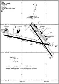
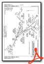
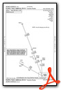
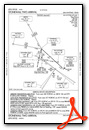
KSSF Airport Diagram
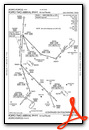
VFR Chart of KSSF
Sectional Charts at SkyVector.com
IFR Chart of KSSF
Enroute Charts at SkyVector.com
Location Information for KSSF
Coordinates: N29°20.22' / W98°28.26'Located 06 miles S of San Antonio, Texas on 360 acres of land. View all Airports in Texas.
Surveyed Elevation is 577 feet MSL.
Operations Data
|
|
Airport Communications
| ATIS: | 128.8 |
|---|---|
| ASOS: | Tel. 210-927-9391 |
| STINSON TOWER: | 118.2 379.9 |
| STINSON GROUND: | 121.7 379.9 |
| SAN ANTONIO APPROACH: | 125.7 290.225 |
| SAN ANTONIO DEPARTURE: | 125.7 290.225 |
| CLEARANCE DELIVERY: | 121.7 ;WHEN SSF TWR CLSD. |
| QERVO RNAV STAR: | 127.1 269.1 |
| CRVZA RNAV STAR: | 125.7 290.225 |
| DNKIN RNAV STAR: | 125.1 307.0 |
| EMERG: | 121.5 243.0 |
| POPPO RNAV STAR: | 125.1 |
| CTAF: | 118.200 |
| POPPO RNV STAR: | 307.0 |
| UNICOM: | 122.950 |
| ATIS at SKF (6.4 NW): | 120.45 |
| ASOS at SAT (11.8 N): | 210-939-4003 |
| D-ATIS at SAT (11.8 N): | 118.9 |
Nearby Navigation Aids
|
| ||||||||||||||||||||||||||||||||||||||||||||||||||||||||||||


Runway 10/28
| Dimensions: | 5000 x 100 feet / 1524 x 30 meters | |
|---|---|---|
| Surface: | Asphalt in Good Condition | |
| Weight Limits: | S-30, D-75 | |
| Edge Lighting: | Medium Intensity | |
| Runway 10 | Runway 28 | |
| Coordinates: | N29°20.31' / W98°28.86' | N29°20.13' / W98°27.94' |
| Elevation: | 577.6 | 565.1 |
| Runway Heading: | 103° True | 283° True |
| Displaced Threshold: | 450 Feet | |
| Declared Distances: | TORA:5000 TODA:5000 ASDA:5000 LDA:4550 | TORA:5000 TODA:5000 ASDA:4677 LDA:4677 |
| Markings: | Non-Precision Instrument in good condition. | Non-Precision Instrument in good condition. |
| Glide Slope Indicator | P4L (3.00° Glide Path Angle) | P4L (3.00° Glide Path Angle) |
| REIL: | Yes | Yes |
| Obstacles: | 29 ft Trees 205 ft from runway, 25 ft left of center APCH SLOPE 25:1 TO DSPLCD THLD OVR 61 FT TREES, 1585 FT DSTC. 7 FT FENCE, 0 FT DSTC, 167 FT R; 15 FT RD O FT DSTC. |
25 ft Trees 730 ft from runway, 230 ft right of center |
Runway 14/32
| Dimensions: | 4128 x 100 feet / 1258 x 30 meters | |
|---|---|---|
| Surface: | Asphalt in Good Condition | |
| Weight Limits: | S-12, D-20 | |
| Edge Lighting: | Medium Intensity | |
| Runway 14 | Runway 32 | |
| Coordinates: | N29°20.49' / W98°28.32' | N29°19.93' / W98°27.88' |
| Elevation: | 572.0 | 552.9 |
| Runway Heading: | 145° True | 325° True |
| Displaced Threshold: | 583 Feet | 372 Feet |
| Declared Distances: | TORA:4128 TODA:4128 ASDA:3881 LDA:3297 | TORA:4128 TODA:4128 ASDA:3902 LDA:3530 |
| Markings: | Non-Precision Instrument in good condition. | Non-Precision Instrument in good condition. |
| Glide Slope Indicator | P2R (3.00° Glide Path Angle) | P4L (3.00° Glide Path Angle) |
| REIL: | Yes | Yes |
| Obstacles: | 35 ft Trees 201 ft from runway APCH SLOPE 22:1 TO DSPLCD THLD OVR 50 FT TREES, 1100 FT DSTC. 7 FT FENCE 21 FT DSTC. 14 FT RD, 35 FT DSTC ACRS APCH.. |
25 ft Trees 201 ft from runway APCH SLOPE 24:1 TO DSPLCD THLD OVR 35 FT TREES, 835 FT DSTC. 6 FT FENCE 0 FT DSTC;15 FT RD 20 FT DSTC, 120 FT L |
Services Available
| Fuel: | 100LL (blue), Jet-A |
|---|---|
| Transient Storage: | Hangars,Tiedowns |
| Airframe Repair: | MAJOR |
| Engine Repair: | MAJOR |
| Bottled Oxygen: | NONE |
| Bulk Oxygen: | NONE |
| Other Services: | CHARTER SERVICE,PILOT INSTRUCTION,AIRCRAFT RENTAL,AIRCRAFT SALES |
Ownership Information
| Ownership: | Publicly owned | |
|---|---|---|
| Owner: | CITY OF SAN ANTONIO | |
| 8535 MISSION RD | ||
| SAN ANTONIO, TX 78214 | ||
| 210-207-1800 | ||
| Manager: | PETER PERSHA | |
| 8535 MISSION RD | ||
| SAN ANTONIO, TX 78214 | ||
| 210-207-1800 | ||
Other Remarks
- NUMEROUS ACFT OPERATING AT OR ABOVE 2500 FT MSL IN THE STINSON ARPT TFC AREA UNDER THE CTL OF SAN ANTONIO APCH.
- PAEW ADJ ALL TWYS & RAMP AREAS MON-FRI 0700-1759.
- FOR CD WHEN ATCT IS CLSD CTC SAT APCH AT 210-805-5516.
- DUSK-DAWN. MIRL RWY 10/28 & 14/32 PRESET MED INTST WHEN ATCT CLSD.
Weather Minimums

Standard Terminal Arrival (STAR) Charts
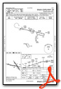
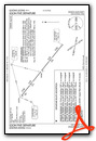
- CENTERPOINT THREE
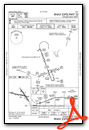
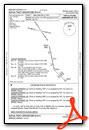
- CRVZA TWO (RNAV)
- CRVZA TWO (RNAV), CONT.1

- CRVZA TWO (RNAV), CONT.2
- DNKIN TWO (RNAV)
- DNKIN TWO (RNAV), CONT.1
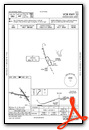
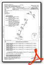
- LEMIG TWO

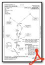
- MARCS TWO
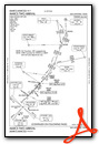
- MARCS TWO, CONT.1
- POPPO TWO (RNAV)
- POPPO TWO (RNAV), CONT.1
- POPPO TWO (RNAV), CONT.2
- QERVO THREE (RNAV)
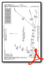
- QERVO THREE (RNAV), CONT.1
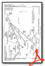
- QERVO THREE (RNAV), CONT.2
- STONEWALL TWO
Instrument Approach Procedure (IAP) Charts
Departure Procedure (DP) Charts
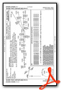
Nearby Airports with Instrument Procedures
| ID | Name | Heading / Distance | ||
|---|---|---|---|---|
 |
KSKF | Kelly Field Airport | 296° | 6.4 |
|
KSAT | San Antonio International Airport | 000° | 11.8 |
|
KRND | Randolph AFB Airport | 041° | 15.3 |
|
KCVB | Castroville Municipal Airport | 271° | 19.9 |
|
KPEZ | Pleasanton Municipal Airport | 186° | 23.1 |
|
5C1 | Boerne Stage Airfield Airport | 333° | 25.9 |
|
23R | Devine Municipal Airport | 244° | 27.4 |
|
KBAZ | New Braunfels Ntl Airport | 045° | 31.4 |
|
KHDO | South Texas Regional At Hondo Airport | 272° | 37.1 |
|
2R9 | Kenedy Regional Airport | 133° | 44.2 |
|
T30 | Mc Kinley Field Airport | 227° | 45.5 |
|
KHYI | San Marcos Regional Airport | 043° | 46.0 |
Airport Images
Do you have a recent image of this airport? Upload it here!


