Login
Register


CVB
Castroville Municipal Airport
Official FAA Data Effective 2025-12-25 0901Z
Chart Supplement

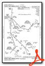
VFR Chart of KCVB
Sectional Charts at SkyVector.com
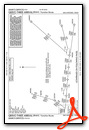
IFR Chart of KCVB
Enroute Charts at SkyVector.com
Location Information for KCVB
Coordinates: N29°20.54' / W98°51.07'Located 02 miles SE of Castroville, Texas on 459 acres of land. View all Airports in Texas.
Surveyed Elevation is 773 feet MSL.
Operations Data
|
|
Airport Communications
| AWOS-3: | 119.25 Tel. 830-931-0232 |
|---|---|
| SAN ANTONIO APPROACH: | 118.05 353.5 |
| SAN ANTONIO DEPARTURE: | 118.05 353.5 |
| CRVZA RNAV STAR: | 125.7 290.225 |
| POPPO RNV STAR: | 307.0 |
| POPPO RNAV STAR: | 125.1 |
| CTAF: | 122.800 |
| UNICOM: | 122.800 |
| QERVO RNAV STAR: | 127.1 269.1 |
| DNKIN RNAV STAR: | 125.1 307.0 |
| ATIS at SKF (14.4 E): | 120.45 |
| ASOS at HDO (17.1 W): | 119.675 830-426-3060 |
| ASOS at SSF (19.9 E): | 210-927-9391 |
Nearby Navigation Aids
|
| ||||||||||||||||||||||||||||||||||||||||||||||||||||||||||||


Runway 16/34
| Dimensions: | 5001 x 75 feet / 1524 x 23 meters | |
|---|---|---|
| Surface: | Asphalt in Excellent Condition | |
| Weight Limits: | 11 /F/C/X/T, S-26, D-40
PAVEMENT STRENGTH INCREASE REQUEST BASED ON KSA ENGINEERING REPORT
PAVEMENT STRENGTH INCREASE REQUEST BASED ON KSA ENGINEERING REPORT
PAVEMENT STRENGTH INCREASE REQUEST BASED ON KSA ENGINEERING REPORT
| |
| Edge Lighting: | Medium Intensity | |
| Runway 16 | Runway 34 | |
| Coordinates: | N29°20.93' / W98°51.23' | N29°20.15' / W98°50.92' |
| Elevation: | 773.9 | 762.2 |
| Traffic Pattern: | Left | Right |
| Runway Heading: | 161° True | 341° True |
| Markings: | Non-Precision Instrument in good condition. | Non-Precision Instrument in good condition. |
| Glide Slope Indicator | P2L (3.00° Glide Path Angle) | P2L (3.00° Glide Path Angle) |
Services Available
| Fuel: | 100LL (blue), Jet-A |
|---|---|
| Transient Storage: | Tiedowns |
| Airframe Repair: | NOT AVAILABLE |
| Engine Repair: | NOT AVAILABLE |
| Bottled Oxygen: | NOT AVAILABLE |
| Bulk Oxygen: | NONE |
| Other Services: | CROP DUSTING SERVICES,PILOT INSTRUCTION,PARACHUTE JUMP ACTIVITY,AIRCRAFT RENTAL PAJA BLW 10000 FT MSL FRI-SUN 0800-1600. |
Ownership Information
| Ownership: | Publicly owned | |
|---|---|---|
| Owner: | CITY OF CASTROVILLE | |
| 1209 FIORELLA ST | ||
| CASTROVILLE, TX 78009 | ||
| 830-931-4070 | ||
| Manager: | MICHAEL HALEY | COMMUNITY DEV. DIR/AMGR. |
| 10500 AIRPORT ROAD | ||
| CASTROVILLE, TX 78009 | ||
| 830-538-2782 | ||
Other Remarks
- BRIGHT LGTS AT BALL PARK FM APR-JULY.
- FOR CD CTC SAN ANTONIO APCH AT 210-805-5516.
- 0LL FUEL AVBL 24 HRS SELF SVC. JET A FULL SERV DURG ATND HRS.
- SS-SR MIRL RWY 16/34 PRESET LOW INTST; TO INCR INTST ACTVT - CTAF.
Weather Minimums


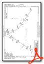
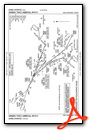
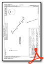
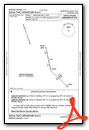
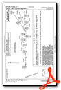
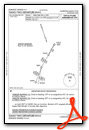
Standard Terminal Arrival (STAR) Charts
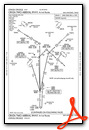

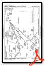
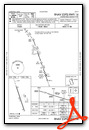
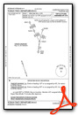
Instrument Approach Procedure (IAP) Charts
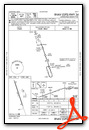
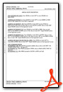
Departure Procedure (DP) Charts
Nearby Airports with Instrument Procedures
| ID | Name | Heading / Distance | ||
|---|---|---|---|---|
 |
23R | Devine Municipal Airport | 201° | 13.1 |
|
KSKF | Kelly Field Airport | 079° | 14.4 |
|
KHDO | South Texas Regional At Hondo Airport | 273° | 17.1 |
|
KSSF | Stinson Municipal Airport | 090° | 19.9 |
|
KSAT | San Antonio International Airport | 060° | 23.1 |
|
5C1 | Boerne Stage Airfield Airport | 019° | 24.2 |
|
KPEZ | Pleasanton Municipal Airport | 143° | 29.0 |
|
KRND | Randolph AFB Airport | 069° | 32.0 |
|
T30 | Mc Kinley Field Airport | 203° | 34.0 |
|
KERV | Kerrville Municipal/Louis Schreiner Field Airport | 342° | 39.9 |
|
KUVA | Garner Field Airport | 260° | 47.5 |
|
KBAZ | New Braunfels Ntl Airport | 062° | 47.6 |
Airport Images

By: breana.soto@cas...

By: breana.soto@cas...


Comments
New pilots lounge
Great airport: New pilots lounge in 2022. Crew car. 24 hour everything. The hot water heater has been fixed so no more cold showers. Coffee. Crazy expensive drink machine. -Bring your own tie down ropes-. Check out the visitors log. Very nice and comfy environment.