Login
Register
20VA
Woodford Airpark Airport
Official FAA Data Effective 2025-11-27 0901Z
VFR Chart of 20VA
Sectional Charts at SkyVector.com
IFR Chart of 20VA
Enroute Charts at SkyVector.com
Location Information for 20VA
Coordinates: N38°4.94' / W77°29.30'Located 07 miles NW of Bowling Green, Virginia on 20 acres of land. View all Airports in Virginia.
Estimated Elevation is 245 feet MSL.
Operations Data
|
|
Airport Communications
| UNICOM: | 122.800 |
|---|---|
| AWOS-3 at EZF (11.2 N): | 128.125 540-372-6794 |
| AWOS-3 at 7W4 (14.0 SW): | 120.775 540-872-0303 |
| AWOS-3 at RMN (19.0 N): | 126.325 540-657-8283 |
Nearby Navigation Aids
|
| ||||||||||||||||||||||||||||||||||||||||||||||||||||||||||||
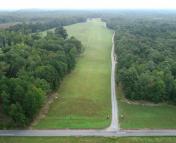
Runway 08/26
| Dimensions: | 2600 x 150 feet / 792 x 46 meters | |
|---|---|---|
| Surface: | Turf | |
| Runway 08 | Runway 26 | |
| Obstacles: | 50 ft Trees 800 ft from runway | 50 ft Trees 800 ft from runway |
Ownership Information
| Ownership: | Privately Owned | |
|---|---|---|
| Owner: | KIRK HAARKLAU | ARPT LOCATED AT 13253 BULL CHURCH RD, WOODFORD, VA 22580. |
| 13253 BULL CHURCH ROAD | ||
| WOODFORD, VA 22580 | ||
| 845-551-7342 | ||
| Manager: | ||
Other Remarks
- FOR CD CTC POTOMAC APCH AT 866-640-4124.
Nearby Airports with Instrument Procedures
| ID | Name | Heading / Distance | ||
|---|---|---|---|---|
 |
KEZF | Shannon Airport | 009° | 11.2 |
 |
7W4 | Lake Anna Airport | 240° | 14.1 |
 |
KRMN | Stafford Regional Airport | 004° | 19.0 |
 |
KOFP | Hanover County Municipal Airport | 173° | 22.5 |
 |
KLKU | Louisa County/Freeman Field Airport | 259° | 23.2 |
 |
KNYG | Quantico Mcaf (Turner Field) Airport | 018° | 26.7 |
 |
KOMH | Orange County Airport | 290° | 28.2 |
 |
KXSA | Tappahannock/Essex County Airport | 115° | 31.2 |
 |
KCJR | Culpeper Regional Airport | 326° | 31.8 |
 |
KHWY | Warrenton/Fauquier Airport | 340° | 32.0 |
 |
KGVE | Gordonsville Municipal Airport | 278° | 32.4 |
 |
KRIC | Richmond International Airport | 166° | 35.5 |


