Login
Register


LCQ
Lake City Gateway Airport
Official FAA Data Effective 2026-02-19 0901Z
Chart Supplement

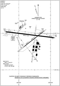
KLCQ Airport Diagram
VFR Chart of KLCQ
Sectional Charts at SkyVector.com
IFR Chart of KLCQ
Enroute Charts at SkyVector.com
Location Information for KLCQ
Coordinates: N30°10.92' / W82°34.61'Located 03 miles E of Lake City, Florida on 1250 acres of land. View all Airports in Florida.
Surveyed Elevation is 200 feet MSL.
Operations Data
|
|
Airport Communications
| AWOS-3: | 120.675 Tel. 386-754-9366 |
|---|---|
| LAKE CITY TOWER: | 119.2 314.6 |
| LAKE CITY GROUND: | 121.9 |
| EMERG: | 121.5 |
| CTAF: | 119.200 |
| UNICOM: | 122.950 |
| AWOS-3 at 24J (24.3 W): | 118.225 386-362-1731 |
| ATIS at GNV (33.5 SE): | 127.15 |
| ASOS at GNV (33.5 SE): | 127.15 352-335-8672 |
- APCH/DEP SVC PRVDD BY JACKSONVILLE ARTCC ON FREQS 125.375/254.325 (LAKE CITY RCAG).
- OWNED/OPERATED BY CITY OF LAKE CITY, FL.
- ATCT MAY BE OPEN AT OTHER THAN PUBLISHED HRS; MONITOR CTAF AT ALL TIMES.
Nearby Navigation Aids
|
| ||||||||||||||||||||||||||||||||||||||||||||||||||||||||||||


Runway 10/28
| Dimensions: | 8003 x 150 feet / 2439 x 46 meters | |
|---|---|---|
| Surface: | Asphalt in Good Condition | |
| Weight Limits: | 42 /F/A/W/T, S-75, D-105, ST-250 | |
| Edge Lighting: | Medium Intensity | |
| Runway 10 | Runway 28 | |
| Coordinates: | N30°11.04' / W82°35.41' | N30°10.88' / W82°33.90' |
| Elevation: | 198.1 | 196.3 |
| Traffic Pattern: | Left | Right |
| Runway Heading: | 97° True | 277° True |
| Markings: | Non-Precision Instrument in fair condition. | Non-Precision Instrument in fair condition. |
| Glide Slope Indicator | P2L (3.00° Glide Path Angle) | P2L (3.00° Glide Path Angle) |
| REIL: | Yes | Yes |
| Obstacles: | 43 ft Trees 1435 ft from runway, 180 ft left of center | 48 ft Trees 1885 ft from runway, 250 ft right of center |
Runway 05/23
| Dimensions: | 4000 x 75 feet / 1219 x 23 meters | |
|---|---|---|
| Surface: | Asphalt in Excellent Condition | |
| Edge Lighting: | Medium Intensity | |
| Runway 05 | Runway 23 | |
| Coordinates: | N30°10.64' / W82°34.83' | N30°11.05' / W82°34.23' |
| Elevation: | 185.5 | 194.8 |
| Traffic Pattern: | Left | Left |
| Runway Heading: | 52° True | 232° True |
| Markings: | Non-Precision Instrument in good condition. | Non-Precision Instrument in good condition. |
| Obstacles: | 64 ft Trees 1690 ft from runway, 250 ft right of center | 50 ft Trees 1625 ft from runway, 265 ft left of center |
Services Available
| Fuel: | 100LL (blue), Jet-A |
|---|---|
| Transient Storage: | Tiedowns |
| Airframe Repair: | MINOR |
| Engine Repair: | MINOR |
| Bottled Oxygen: | NONE |
| Bulk Oxygen: | NONE |
| Other Services: | AIR AMBULANCE SERVICES,PILOT INSTRUCTION |
Ownership Information
| Ownership: | Publicly owned | |
|---|---|---|
| Owner: | CITY OF LAKE CITY | CTC PERSON: DEMETRIUS JOHNSON |
| 205 NORTH MARION AVE | ||
| LAKE CITY, FL 32055 | ||
| 386-719-5785 | ||
| Manager: | ED BUNNELL | |
| 3524 E US HWY 90 | ||
| LAKE CITY, FL 32055 | ||
| 386-752-1066 | ||
Other Remarks
- UNLIT 60 FT POLES ON MOVEMENT AREA. HELICOPTERS ADVISED TO TAXI ON PAVED AREAS ONLY.
- WHEN ATCT CLSD, FOR CD CTC JACKSONVILLE ARTCC AT 904-845-1592.
- ACTVT REIL RWY 10 & 28; MIRL RWY 5/23 & 10/28 - CTAF.
Weather Minimums


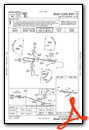
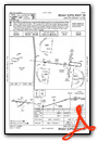
Instrument Approach Procedure (IAP) Charts
Nearby Airports with Instrument Procedures
| ID | Name | Heading / Distance | ||
|---|---|---|---|---|
 |
24J | Suwannee County Airport | 287° | 24.3 |
|
KGNV | Gainesville Regional Airport | 151° | 33.5 |
|
42J | Keystone Heights Airport | 126° | 34.2 |
|
KVQQ | Cecil Airport | 086° | 36.4 |
|
KHEG | Herlong Recreational Airport | 081° | 40.5 |
|
KCTY | Cross City Airport | 220° | 42.8 |
|
KNIP | Jacksonville NAS (Towers Field) Airport | 085° | 46.9 |
|
KJAX | Jacksonville International Airport | 067° | 49.8 |
|
X60 | Williston Regional Airport | 173° | 49.8 |
|
KVLD | Valdosta Regional Airport | 314° | 51.0 |
|
KFPY | Perry-Foley Airport | 262° | 52.7 |
|
KHOE | Homerville Airport | 348° | 53.4 |
Airport Images
Do you have a recent image of this airport? Upload it here!


