Login
Register


CTY
Cross City Airport
Official FAA Data Effective 2026-01-22 0901Z
Chart Supplement

VFR Chart of KCTY
Sectional Charts at SkyVector.com
IFR Chart of KCTY
Enroute Charts at SkyVector.com
Location Information for KCTY
Coordinates: N29°38.13' / W83°6.28'Located 01 miles E of Cross City, Florida on 591 acres of land. View all Airports in Florida.
Surveyed Elevation is 42 feet MSL.
Operations Data
|
|
Airport Communications
| AWOS-3PT: | 120.775 Tel. 352-498-0221 |
|---|---|
| UNICOM: | 122.800 |
| CTAF: | 122.800 |
| AWOS-3PT at FPY (35.8 NW): | 118.375 850-838-3526 |
| AWOS-3T at X60 (37.2 SE): | 118.425 352-528-9949 |
| AWOS-3 at 24J (40.1 N): | 118.225 386-362-1731 |
- APCH/DEP SVC PRVDD BY JACKSONVILLE ARTCC ON FREQS 127.8/352.0 (PERRY FOLEY RCAG).
Nearby Navigation Aids
|
| ||||||||||||||||||||||||||||||||||||||||||||||||


Runway 04/22
| Dimensions: | 5005 x 75 feet / 1526 x 23 meters | |
|---|---|---|
| Surface: | Asphalt in Excellent Condition | |
| Weight Limits: | 8 /F/B/Y/T, S-13 | |
| Edge Lighting: | Medium Intensity | |
| Runway 04 | Runway 22 | |
| Coordinates: | N29°38.04' / W83°6.47' | N29°38.64' / W83°5.82' |
| Elevation: | 41.7 | 39.3 |
| Traffic Pattern: | Left | Left |
| Runway Heading: | 44° True | 224° True |
| Markings: | Non-Precision Instrument in good condition. | Non-Precision Instrument in good condition. |
| Glide Slope Indicator | P2L (3.00° Glide Path Angle) | P2L (3.00° Glide Path Angle) |
| Obstacles: | 55 ft Trees 1355 ft from runway, 150 ft right of center | 63 ft Trees 1270 ft from runway, 60 ft left of center |
Runway 13/31
| Dimensions: | 5001 x 100 feet / 1524 x 30 meters | |
|---|---|---|
| Surface: | Asphalt-Concrete in Fair Condition FIRST 300 FT RWY 31 CONC. | |
| Weight Limits: | 10 /R/C/W/T, S-13 | |
| Edge Lighting: | Medium Intensity | |
| Runway 13 | Runway 31 | |
| Coordinates: | N29°38.21' / W83°6.76' | N29°37.64' / W83°6.08' |
| Elevation: | 41.0 | 40.6 |
| Traffic Pattern: | Left | Left |
| Runway Heading: | 134° True | 314° True |
| Markings: | Non-Precision Instrument in poor condition. | Non-Precision Instrument in poor condition. |
| Glide Slope Indicator | P2L (3.00° Glide Path Angle) | P2L (3.00° Glide Path Angle) |
| REIL: | Yes | Yes |
| Obstacles: | 56 ft Trees 1430 ft from runway, 250 ft right of center | 47 ft Trees 1800 ft from runway, 60 ft right of center |
Services Available
| Fuel: | 100LL (blue), Jet-A |
|---|---|
| Transient Storage: | Tiedowns |
| Airframe Repair: | MAJOR |
| Engine Repair: | MAJOR |
| Bottled Oxygen: | NONE |
| Bulk Oxygen: | NONE |
Ownership Information
| Ownership: | Publicly owned | |
|---|---|---|
| Owner: | DIXIE COUNTY | CONTACT PERSON: MIKE CASSIDY, 352-498-1426 FAX: 352-498-1207 |
| COUNTY COURTHOUSE, P.O. BOX 2600 | ||
| CROSS CITY, FL 32628 | ||
| 352-498-1206 | ||
| Manager: | CLINT BEAUCHAMP | AIRPORT PHYSICAL ADDRESS: 1516 AIRPORT ROAD., CROSS CITY, FL 32628, 352-498-1200 |
| 508 NE 241 ST, 508 NE 241 ST | ||
| CROSS CITY, FL 32628 | ||
| 352-498-6656 | ||
Other Remarks
- THIS AIRPORT HAS BEEN SURVEYED BY THE NATIONAL GEODETIC SURVEY.
- RY 04/22 HAS TREES IN TRANSITION SFC NORTHWEST.
- FOR CD IF UNA TO CTC ON FSS FREQ, CTC JACKSONVILLE ARTCC AT 904-845-1592.
- RWY 13 MRKGS FADED.
- RWY 31 MRKGS FADED.
- ACTVT REIL 13 & 31; PAPI RWY 04, 22, 13 & 31; MIRL RWY 04/22 - CTAF.
Weather Minimums

Instrument Approach Procedure (IAP) Charts
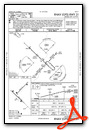
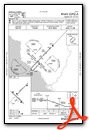
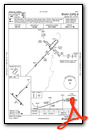
Nearby Airports with Instrument Procedures
| ID | Name | Heading / Distance | ||
|---|---|---|---|---|
 |
KFPY | Perry-Foley Airport | 316° | 36.0 |
|
X60 | Williston Regional Airport | 116° | 37.2 |
|
24J | Suwannee County Airport | 005° | 40.0 |
|
KLCQ | Lake City Gateway Airport | 039° | 42.8 |
|
KGNV | Gainesville Regional Airport | 085° | 43.7 |
|
X35 | Marion County Airport | 131° | 51.4 |
|
KOCF | Ocala International-Jim Taylor Field Airport | 120° | 53.9 |
|
KCGC | Crystal River/Davis Field Airport | 148° | 53.7 |
|
42J | Keystone Heights Airport | 076° | 56.6 |
|
KINF | Inverness Airport | 140° | 64.7 |
|
KVLD | Valdosta Regional Airport | 352° | 69.2 |
|
KVQQ | Cecil Airport | 061° | 72.9 |
Airport Images
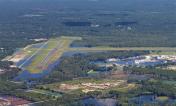
By: chabrier

By: chabrier


