Login
Register


H04
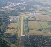
Vinita Municipal Airport
Official FAA Data Effective 2025-11-27 0901Z
Chart Supplement

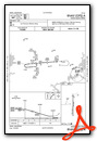
VFR Chart of H04
Sectional Charts at SkyVector.com
IFR Chart of H04
Enroute Charts at SkyVector.com
Location Information for H04
Coordinates: N36°36.88' / W95°9.10'Located 02 miles SE of Vinita, Oklahoma on 112 acres of land. View all Airports in Oklahoma.
Estimated Elevation is 695 feet MSL.
Operations Data
|
|
Airport Communications
| CTAF: | 122.900 |
|---|---|
| AWOS-3PT at 1K8 (8.0 SE): | 118.150 918-782-2047 |
| AWOS-3PT at GMJ (19.9 E): | 119.025 918-786-8350 |
| AWOS-3PT at MIO (21.9 NE): | 119.675 918-544-6164 |
- APCH/DEP CTL SVC PRVDD BY KANSAS CITY ARTCC (ZKC) ON 128.6/282.325 (EDNA RCAG).
Nearby Navigation Aids
|
| ||||||||||||||||||||||||||||||||||||||||||||||||||||||||||||


Runway 17/35
| Dimensions: | 4209 x 60 feet / 1283 x 18 meters | |
|---|---|---|
| Surface: | Asphalt-Concrete in Good Condition | |
| Edge Lighting: | Medium Intensity | |
| Runway 17 | Runway 35 | |
| Coordinates: | N36°37.22' / W95°9.10' | N36°36.53' / W95°9.10' |
| Elevation: | 695.2 | 678.6 |
| Traffic Pattern: | Left | Left |
| Runway Heading: | 179° True | 359° True |
| Displaced Threshold: | 210 Feet | |
| Markings: | Basic in good condition. | Basic in good condition. |
| Glide Slope Indicator | P2L (3.00° Glide Path Angle) | P2L (3.00° Glide Path Angle) |
| Obstacles: | 6 ft Fence 228 ft from runway RWY 17; 47 FT TREE 757 FT FM THLD, 120 FT RIGHT OF EXTDD CNTRLN. APCH SLOPE 20:1 TO DTHR. |
30 ft Trees 605 ft from runway, 32 ft left of center |
Services Available
| Fuel: | 100LL (blue) |
|---|---|
| Transient Storage: | Tiedowns |
| Airframe Repair: | NONE |
| Engine Repair: | NONE |
| Bottled Oxygen: | NONE |
| Bulk Oxygen: | NONE |
| Other Services: | CROP DUSTING SERVICES |
Ownership Information
| Ownership: | Publicly owned | |
|---|---|---|
| Owner: | CITY OF VINITA | |
| 104 E. ILLINOIS, PO BOX 329 | ||
| VINITA, OK 74301 | ||
| 918-256-6468 | ||
| Manager: | BRIAN PRINCE | DIRECTOR OF OPERATIONS. ARPT ATTENDANT: TERRY WILLIAMS 918-397-0193. |
| 747 E. AIRPORT ROAD, 104 E. ILLINOIS | ||
| VINITA, OK 74301 | ||
| 918-244-7260 | ||
Other Remarks
- ULTRALIGHT ACTVTY ON & INVOF ARPT.
- INTERSTATE HWY 425 FT NORTH OF RY 17 END.
- FOR CD CTC KANSAS CITY ARTCC AT 913-254-8508.
- 0LL 24/7 SELF SERVE 100LL AVAILABLE W/ CC
- ACTVT MIRL RWY 17/35 - CTAF.
Weather Minimums

Instrument Approach Procedure (IAP) Charts
Nearby Airports with Instrument Procedures
| ID | Name | Heading / Distance | ||
|---|---|---|---|---|
 |
1K8 | South Grand Lake Regional Airport | 121° | 7.8 |
|
KGMJ | Grove Regional Airport | 091° | 20.0 |
|
KMIO | Miami Regional Airport | 035° | 21.8 |
|
H71 | Mid-America Industrial Airport | 200° | 24.9 |
|
KGCM | Claremore Regional Airport | 219° | 25.0 |
|
KCFV | Coffeyville Municipal Airport | 324° | 35.1 |
|
5M5 | Crystal Lake Airport | 115° | 37.9 |
|
KEOS | Neosho Hugh Robinson Airport | 071° | 38.5 |
|
H68 | Hefner-Easley Airport | 193° | 40.0 |
|
KSLG | Smith Field Airport | 128° | 40.9 |
|
KTQH | Tahlequah Municipal Airport | 170° | 41.6 |
|
KBVO | Bartlesville Municipal Airport | 282° | 42.4 |
Airport Images

By: KBurkhardt
By: Rod


