Login
Register


4R5
Major Gilbert Field Airport
Official FAA Data Effective 2025-12-25 0901Z
Chart Supplement

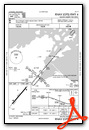
VFR Chart of 4R5
Sectional Charts at SkyVector.com
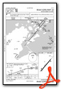
IFR Chart of 4R5
Enroute Charts at SkyVector.com
Location Information for 4R5
Coordinates: N46°47.32' / W90°45.52'Located 02 miles NE of La Pointe, Wisconsin on 136 acres of land. View all Airports in Wisconsin.
Surveyed Elevation is 648 feet MSL.
Operations Data
|
|
Airport Communications
| AWOS-3PT: | 119.375 Tel. 715-747-5519 |
|---|---|
| CTAF: | 122.900 |
| ASOS at ASX (15.9 SW): | 126.775 715-682-5541 |
| AWOS-3PT at IWD (30.2 SE): | 125.175 906-932-4039 |
| AWOS-3PT at TWM (43.4 W): | 119.325 218-834-6591 |
- APCH/DEP SVC PRVDD BY MINNEANAPOLIS ARTCC (ZMP) ON FREQ 133.55 (IRONWOOD RCAG).
Nearby Navigation Aids
|
| ||||||||||||||||||||||||||||||||||||||||||||||||


Runway 04/22
| Dimensions: | 3000 x 75 feet / 914 x 23 meters | |
|---|---|---|
| Surface: | Asphalt in Excellent Condition | |
| Weight Limits: | S-12 | |
| Edge Lighting: | Medium Intensity | |
| Runway 04 | Runway 22 | |
| Coordinates: | N46°47.13' / W90°45.75' | N46°47.51' / W90°45.29' |
| Elevation: | 624.3 | 648.6 |
| Traffic Pattern: | Left | Left |
| Runway Heading: | 40° True | 220° True |
| Markings: | Non-Precision Instrument in good condition. | Non-Precision Instrument in good condition. |
| Glide Slope Indicator | P2L (3.75° Glide Path Angle) | P2L (3.75° Glide Path Angle) |
| REIL: | Yes | |
| Obstacles: | 75 ft Trees 750 ft from runway, 275 ft left of center | 61 ft Trees 430 ft from runway, 245 ft right of center 40 FT TREES 190 FT FM RWY END, 230 FT L. |
Services Available
| Fuel: | NONE |
|---|---|
| Transient Storage: | Tiedowns |
| Airframe Repair: | NONE |
| Engine Repair: | NONE |
| Bottled Oxygen: | NONE |
| Bulk Oxygen: | NONE |
Ownership Information
| Ownership: | Publicly owned | |
|---|---|---|
| Owner: | TOWN OF LAPOINTE | |
| PO BOX 270 | ||
| LA POINTE, WI 54850 | ||
| 715-747-6914 | ||
| Manager: | PAUL WILHARM | |
| BOX 270 | ||
| LA POINTE, WI 54850 | ||
| (612) 685-0445 | ||
Other Remarks
- DEER & WATERFOWL ON & INVOF ARPT.
- FOR CD CTC MINNEAPOLIS ARTCC AT 651-463-5588.
- ACTVT REIL RWY 04; PAPI RWY 04 & 22 - CTAF. MIRL RWY 04/22 PRESET TO LOW SS-SR, TO INCR INTST & ACTVT - CTAF.
Weather Minimums
Instrument Approach Procedure (IAP) Charts
Nearby Airports with Instrument Procedures
| ID | Name | Heading / Distance | ||
|---|---|---|---|---|
 |
KASX | John F Kennedy Memorial Airport | 204° | 15.9 |
|
KIWD | Gogebic/Iron County Airport | 120° | 30.3 |
|
3CU | Cable Union Airport | 209° | 41.0 |
|
KTWM | Richard B Helgeson Airport | 291° | 43.5 |
|
KPKF | Park Falls Municipal Airport | 164° | 51.9 |
|
KOLG | Solon Springs Municipal Airport | 237° | 52.2 |
|
KDYT | Sky Harbor Airport | 266° | 53.2 |
|
KHYR | Sawyer County Airport | 212° | 53.9 |
|
D25 | Manitowish Waters Airport | 137° | 54.1 |
|
KSUW | Richard I Bong Airport | 264° | 55.4 |
|
KOGM | Ontonagon County/Schuster Field Airport | 086° | 57.4 |
|
KDLH | Duluth International Airport | 273° | 59.2 |
Airport Images
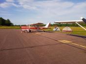
By: thecoolestname36
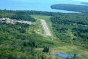
By: skypixsaerials


