Login
Register


3R4
Hart Airport
Official FAA Data Effective 2026-02-19 0901Z
Chart Supplement

VFR Chart of 3R4
Sectional Charts at SkyVector.com
IFR Chart of 3R4
Enroute Charts at SkyVector.com
Location Information for 3R4
Coordinates: N31°32.65' / W93°29.03'Located 02 miles SW of Many, Louisiana on 250 acres of land. View all Airports in Louisiana.
Surveyed Elevation is 318 feet MSL.
Operations Data
|
|
Airport Communications
| POLK APPROACH: | 123.7 261.3 |
|---|---|
| POLK DEPARTURE: | 123.7 261.3 |
| UNICOM: | 122.800 |
| CTAF: | 122.800 |
| AWOS-3 at IER (22.8 NE): | 119.025 318-352-1575 |
| ASOS at POE (33.5 SE): | 134.85 726-780-1210 |
| ATIS at POE (33.5 SE): | 134.85 |
Nearby Navigation Aids
|
| ||||||||||||||||||||||||||||||||||||||||||||||||||||||||||||


Runway 12/30
| Dimensions: | 4402 x 75 feet / 1342 x 23 meters | |
|---|---|---|
| Surface: | Asphalt in Fair Condition | |
| Weight Limits: | S-6 | |
| Edge Lighting: | Medium Intensity | |
| Runway 12 | Runway 30 | |
| Coordinates: | N31°32.84' / W93°29.39' | N31°32.47' / W93°28.67' |
| Elevation: | 318.3 | 307.2 |
| Traffic Pattern: | Left | Left |
| Runway Heading: | 121° True | 301° True |
| Markings: | Non-Precision Instrument in fair condition. | Non-Precision Instrument in fair condition. |
| Glide Slope Indicator | P2L (3.00° Glide Path Angle) | P2L (3.50° Glide Path Angle) |
| REIL: | Yes | Yes |
| Obstacles: | 38 ft Trees 1681 ft from runway, 227 ft right of center | 78 ft Trees 1830 ft from runway |
Services Available
| Fuel: | 100LL (blue) |
|---|---|
| Transient Storage: | Tiedowns |
| Airframe Repair: | NONE |
| Engine Repair: | NONE |
| Bottled Oxygen: | NONE |
| Bulk Oxygen: | NONE |
| Other Services: | PILOT INSTRUCTION |
Ownership Information
| Ownership: | Publicly owned | |
|---|---|---|
| Owner: | CITY OF MANY | |
| PO BOX 1330 | ||
| MANY, LA 71449 | ||
| 318-256-3651 | ||
| Manager: | MILES GREER | |
| 950 AIRPORT RD | ||
| MANY, LA 71449 | ||
| 318-256-5857 | ||
Other Remarks
- GCO AVBL ON FREQ 135.075 THRU POLK APCH AND DE RIDDER FSS.
- FOR CD CTC IF UNA VIA GCO CTC POLK APCH AT 337-531-2352.
- CTC APRT MGR FOR DSGND RAMP SPACE FOR PUB USE.
- 0LL SELF SERVICE FUEL AVBL AFT HRS WITH CREDIT CARD.
- DUSK-DAWN. MIRL RY 12/30, REIL RYS 12 & 30 PRESET LOW INTST DUSK-DAWN; TO INCR INTST ACTVT - CTAF.
Weather Minimums

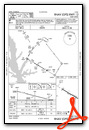
Instrument Approach Procedure (IAP) Charts

Nearby Airports with Instrument Procedures
| ID | Name | Heading / Distance | ||
|---|---|---|---|---|
 |
KIER | Natchitoches Regional Airport | 059° | 22.8 |
|
L39 | Leesville Airport | 162° | 23.7 |
|
0R7 | The Red River Airport | 018° | 28.2 |
|
3F3 | C E 'Rusty' Williams Airport | 335° | 34.8 |
|
F17 | Center Municipal Airport | 296° | 38.5 |
|
KDRI | Beauregard Regional Airport | 170° | 43.3 |
|
KJAS | Jasper County/Bell Field Airport | 215° | 48.6 |
|
0R5 | David G Joyce Airport | 058° | 49.0 |
|
KAEX | Alexandria International Airport | 104° | 49.7 |
|
F88 | Jonesboro Airport | 044° | 55.0 |
|
4F2 | Panola County-Sharpe Field Airport | 312° | 56.3 |
|
KSHV | Shreveport Regional Airport | 342° | 56.8 |
Airport Images
Do you have a recent image of this airport? Upload it here!


