Login
Register


SET
St Charles County Regional/Smartt Field Airport
Official FAA Data Effective 2026-01-22 0901Z
Chart Supplement

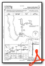
VFR Chart of KSET
Sectional Charts at SkyVector.com
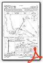
IFR Chart of KSET
Enroute Charts at SkyVector.com
Location Information for KSET
Coordinates: N38°55.78' / W90°25.80'Located 09 miles NE of St Charles, Missouri on 312 acres of land. View all Airports in Missouri.
Surveyed Elevation is 436 feet MSL.
Operations Data
|
|
Airport Communications
| ASOS: | 118.075 Tel. 636-250-4590 |
|---|---|
| SAINT LOUIS APPROACH: | 124.2 353.9 |
| SAINT LOUIS DEPARTURE: | 124.2 353.9 |
| CLEARANCE DELIVERY: | 121.6 |
| UNICOM: | 122.700 |
| CTAF: | 122.700 |
| ASOS at STL (11.0 S): | 314-238-8419 |
| D-ATIS at STL (11.2 S): | 125.025 |
| ATIS at ALN (18.1 E): | 128.0 |
Nearby Navigation Aids
|
| ||||||||||||||||||||||||||||||||||||||||||||||||||||||||||||


Runway 18/36
| Dimensions: | 3800 x 75 feet / 1158 x 23 meters | |
|---|---|---|
| Surface: | Asphalt in Fair Condition | |
| Weight Limits: | S-12 | |
| Edge Lighting: | Medium Intensity | |
| Runway 18 | Runway 36 | |
| Coordinates: | N38°56.01' / W90°25.85' | N38°55.38' / W90°25.86' |
| Elevation: | 432.9 | 436.4 |
| Traffic Pattern: | Left | Left |
| Runway Heading: | 181° True | 1° True |
| Markings: | Non-Precision Instrument in good condition. | Non-Precision Instrument in fair condition. |
| Glide Slope Indicator | P4L (3.00° Glide Path Angle) | V4L RWY 36 VASI OUT OF SERVICE INDEFINITELY |
| REIL: | Yes | |
Runway 09/27
| Dimensions: | 2000 x 75 feet / 610 x 23 meters | |
|---|---|---|
| Surface: | Asphalt in Good Condition | |
| Weight Limits: | S-12 | |
| Edge Lighting: | Medium Intensity | |
| Runway 09 | Runway 27 | |
| Coordinates: | N38°55.94' / W90°25.90' | N38°55.94' / W90°25.48' |
| Elevation: | 433.9 | 435.6 |
| Traffic Pattern: | Left | Left |
| Runway Heading: | 91° True | 271° True |
| Markings: | Basic in good condition. | Basic in good condition. |
Services Available
| Fuel: | 100LL (blue) |
|---|---|
| Transient Storage: | Hangars,Tiedowns |
| Airframe Repair: | MAJOR |
| Engine Repair: | MAJOR |
| Bottled Oxygen: | NONE |
| Bulk Oxygen: | NONE |
| Other Services: | CROP DUSTING SERVICES,CHARTER SERVICE,PILOT INSTRUCTION,AIRCRAFT RENTAL |
Ownership Information
| Ownership: | Publicly owned | |
|---|---|---|
| Owner: | ST CHARLES COUNTY | |
| 201 N. 2ND ST. | ||
| ST CHARLES, MO 63301 | ||
| 636-949-7500 | ||
| Manager: | DENNIS WISS | |
| 6390 GRAFTON FERRY RD | ||
| PORTAGE DES SIOUX, MO 63373 | ||
| 636-949-1893 | ||
Other Remarks
- THIS AIRPORT HAS BEEN SURVEYED BY THE NATIONAL GEODETIC SURVEY.
- HEAVY STUDENT TRNG.
- ARPT CONDS NOT REPORTED MON-FRI 1630L-0800L DLY, FRI 1630L THRU MON 0800L.
- FOR CD CTC ST LOUIS APCH AT 314-890-1017.
- ACTVT MIRL RWY 18/36 AND RWY 09/27 & REIL RWY 18, PAPI RWY 18 - CTAF. DUSK TO DAWN ONLY.
Weather Minimums


Instrument Approach Procedure (IAP) Charts
Nearby Airports with Instrument Procedures
| ID | Name | Heading / Distance | ||
|---|---|---|---|---|
 |
KSTL | St Louis Lambert International Airport | 165° | 11.2 |
|
1H0 | Creve Coeur Airport | 196° | 12.7 |
|
KALN | St Louis Regional Airport | 097° | 18.1 |
|
KSUS | Spirit of St Louis Airport | 213° | 19.1 |
|
KCPS | St Louis Downtown Airport | 148° | 25.1 |
|
KFYG | Washington Regional Airport | 232° | 33.5 |
|
KBLV | Scott AFB/Midamerica St Louis Airport | 129° | 36.2 |
|
3LF | Litchfield Municipal Airport | 068° | 38.0 |
|
H19 | Bowling Green Municipal Airport | 305° | 45.4 |
|
KPPQ | Pittsfield Penstone Municipal Airport | 339° | 45.5 |
|
KGRE | Greenville Airport | 096° | 49.6 |
|
KIJX | Jacksonville Municipal Airport | 009° | 51.4 |
Airport Images
Do you have a recent image of this airport? Upload it here!


Comments
Great Stop!
Great stop. The folks at St. Charles Flying Service are like family, since I flew there often before buying an airplane and moving away. Stopped on a long cross-country for fuel. The line person was very helpful. Quick, easy, attended on the weekends!
Paul Pillar
PA-28-180: N4375T
Senior Flight Test Engineer/Test Conductor
FAA Safety Team (FAAST) Representative
Civil Air Patrol Oklahoma Wing Director of Aerospace Education (DAE)