Login
Register


3O9
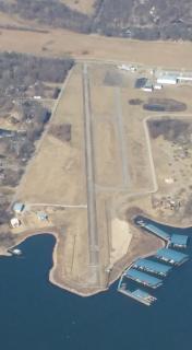
Grand Lake Regional Airport
Official FAA Data Effective 2025-12-25 0901Z
Chart Supplement

VFR Chart of 3O9
Sectional Charts at SkyVector.com
IFR Chart of 3O9
Enroute Charts at SkyVector.com
Location Information for 3O9
Coordinates: N36°34.65' / W94°51.71'Located 10 miles SE of Afton, Oklahoma on 60 acres of land. View all Airports in Oklahoma.
Surveyed Elevation is 792 feet MSL.
Operations Data
|
|
Airport Communications
| UNICOM: | 122.700 |
|---|---|
| CTAF: | 122.700 |
| AWOS-3PT at GMJ (6.2 E): | 119.025 918-786-8350 |
| AWOS-3PT at 1K8 (7.5 W): | 118.150 918-782-2047 |
| AWOS-3PT at MIO (20.2 N): | 119.675 918-544-6164 |
Nearby Navigation Aids
|
| ||||||||||||||||||||||||||||||||||||||||||||||||||||||||||||


Runway 17/35
230 FT SAFETY ZONE ON EITHER ENDS OF RWY MKD AS DSPLCD THLD. | ||
| Dimensions: | 3925 x 60 feet / 1196 x 18 meters | |
|---|---|---|
| Surface: | Concrete in Fair Condition | |
| Weight Limits: | S-30, D-60, ST-80 | |
| Runway 17 | Runway 35 | |
| Traffic Pattern: | Left | Left |
| Runway Heading: | 171° True | 351° True |
| Displaced Threshold: | 230 Feet | 230 Feet |
| Markings: | Basic in poor condition. | Basic in poor condition. |
| Obstacles: | 26 ft Trees 283 ft from runway 25:1 OBS CLNC SLOPE TO DTHR. 40 FT TREES 97 FT RIGHT AT THLD; 7 FT ROAD 40 FT FM RY END & 0B. |
10 FT MARINA BUILDING 60 FT FM RY END & 190 FT RIGHT. |
Services Available
| Fuel: | NONE |
|---|---|
| Transient Storage: | Hangars,Tiedowns |
| Airframe Repair: | NONE |
| Engine Repair: | NONE |
| Bottled Oxygen: | NONE |
| Bulk Oxygen: | NONE |
Ownership Information
| Ownership: | Privately Owned | |
|---|---|---|
| Owner: | WINGS TO WATER LLC | |
| 56351 E. HWY 125 | ||
| MONKEY ISLAND, OK 74331 | ||
| 573-569-4448 | ||
| Manager: | TODD LARAMORE | |
| 56351 E. HWY 125 | ||
| MONKEY ISLAND, OK 74331 | ||
| 573-569-4448 | ||
Other Remarks
- THIS AIRPORT HAS BEEN SURVEYED BY THE NATIONAL GEODETIC SURVEY.
- 130 FT TOWER 1200 FT EAST OF RY 17.
- RY 17 END IS 30 FT HIGHER THAN RY 35 END.
- BIRDS ON & INVOF ARPT.
- FOR CD CTC KANSAS CITY ARTCC AT 913-254-8508.
- MRKGS SVRLY FADED
- MRKGS SVRLY FADED
Nearby Airports with Instrument Procedures
| ID | Name | Heading / Distance | ||
|---|---|---|---|---|
 |
KGMJ | Grove Regional Airport | 073° | 6.2 |
|
1K8 | South Grand Lake Regional Airport | 255° | 7.6 |
|
H04 | Vinita Municipal Airport | 279° | 14.2 |
|
KMIO | Miami Regional Airport | 356° | 19.9 |
|
5M5 | Crystal Lake Airport | 124° | 24.6 |
|
KEOS | Neosho Hugh Robinson Airport | 058° | 26.6 |
|
KSLG | Smith Field Airport | 141° | 29.3 |
|
H71 | Mid-America Industrial Airport | 227° | 31.0 |
|
KXNA | Northwest Arkansas Ntl Airport | 123° | 32.2 |
|
KVBT | Bentonville Municipal/Louise M Thaden Field Airport | 113° | 34.1 |
|
KGCM | Claremore Regional Airport | 240° | 34.4 |
|
KROG | Rogers Exec - Carter Field Airport | 108° | 38.5 |