Login
Register


3W5
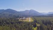
Mears Field Airport
Official FAA Data Effective 2025-11-27 0901Z
Chart Supplement

VFR Chart of 3W5
Sectional Charts at SkyVector.com
IFR Chart of 3W5
Enroute Charts at SkyVector.com
Location Information for 3W5
Coordinates: N48°31.79' / W121°45.49'Located 01 miles S of Concrete, Washington on 29 acres of land. View all Airports in Washington.
Estimated Elevation is 267 feet MSL.
Operations Data
|
|
Airport Communications
| CTAF: | 122.900 |
|---|---|
| AWOS-3 at BVS (26.6 W): | 121.125 360-757-7767 |
| AWOS-3PT at AWO (27.4 SW): | 135.625 360-435-8045 |
| ATIS at BLI (34.7 NW): | 134.45 |
Nearby Navigation Aids
|
| ||||||||||||||||||||||||||||||||||||||||||||||||||||||||||||


Runway 07/25
| Dimensions: | 2609 x 60 feet / 795 x 18 meters | |
|---|---|---|
| Surface: | Asphalt in Fair Condition | |
| Weight Limits: | S-12 | |
| Runway 07 | Runway 25 | |
| Coordinates: | N48°31.79' / W121°45.82' | N48°31.79' / W121°45.17' |
| Traffic Pattern: | Right | Left |
| Markings: | Basic in good condition. | Basic in good condition. |
| Obstacles: | 41 ft Trees 900 ft from runway | 44 ft Trees 720 ft from runway INFREQUENTLY USED ROAD AT 0 FT AND 6 FT BRUSH 80 FT L. |
Helipad H1
HELIPAD FOR EMERGENCY USE ONLY. | ||
| Dimensions: | 40 x 40 feet / 12 x 12 meters | |
|---|---|---|
| Surface: | Concrete in Good Condition | |
Services Available
| Fuel: | 100LL (blue) |
|---|---|
| Transient Storage: | Tiedowns |
| Airframe Repair: | NONE |
| Engine Repair: | NONE |
| Bottled Oxygen: | NONE |
| Bulk Oxygen: | NONE |
| Other Services: | CHARTER SERVICE,GLIDER SERVICE,PILOT INSTRUCTION,AIRCRAFT SALES |
Ownership Information
| Ownership: | Publicly owned | |
|---|---|---|
| Owner: | CITY OF CONCRETE | |
| PO BOX 39 | ||
| CONCRETE, WA 98237 | ||
| 360-853-8401 | ||
| Manager: | JON GUNNARSSON | JON GUNNARSSON: ARPT REP. |
| PO BOX 39 | ||
| CONCRETE, WA 98237 | ||
| 206-972-9181 | ||
Other Remarks
- ALL PATTERNS SOUTH OF ARPT.
- ELK AND DEER FREQUENT BOTH RWY ENDS AND MID-FIELD.
- FOR CD CTC SEATTLE ARTCC AT 253-351-3694.
Nearby Airports with Instrument Procedures
| ID | Name | Heading / Distance | ||
|---|---|---|---|---|
 |
KBVS | Skagit Regional Airport | 262° | 26.7 |
|
KAWO | Arlington Municipal Airport | 216° | 27.4 |
|
KBLI | Bellingham International Airport | 297° | 34.8 |
|
KNUW | Whidbey Island NAS (Ault Field) Airport | 253° | 37.4 |
|
CYXX | Abbotsford Airport | 321° | 38.1 |
|
S43 | Harvey Field Airport | 200° | 40.0 |
|
KOKH | Delaurentis Airport | 245° | 40.2 |
|
KPAE | Seattle Paine Field International Airport | 209° | 42.9 |
|
KORS | Orcas Island Airport | 283° | 47.1 |
|
KFHR | Friday Harbor Airport | 269° | 50.5 |
|
0S9 | Jefferson County International Airport | 236° | 50.9 |
|
KBFI | Boeing Field/King County International Airport | 200° | 63.9 |
Airport Images

By: Yoesmaan
By: kennyw


