Login
Register


43K
Marion Municipal Airport
Official FAA Data Effective 2026-01-22 0901Z
Chart Supplement

VFR Chart of 43K
Sectional Charts at SkyVector.com
IFR Chart of 43K
Enroute Charts at SkyVector.com
Location Information for 43K
Coordinates: N38°20.26' / W96°59.29'Located 02 miles SE of Marion, Kansas on 160 acres of land. View all Airports in Kansas.
Estimated Elevation is 1390 feet MSL.
Operations Data
|
|
Airport Communications
| CTAF: | 122.900 |
|---|---|
| AWOS-3PT at EWK (21.6 SW): | 123.875 316-283-8789 |
| AWOS-3P at MPR (33.0 W): | 119.025 620-798-1650 |
| AWOS-2 at 1K1 (34.3 S): | 118.3 316-530-6004 |
Nearby Navigation Aids
|
| ||||||||||||||||||||||||||||||||||||||||||||||||||||||||||||


Runway 03/21
| Dimensions: | 2745 x 95 feet / 837 x 29 meters | |
|---|---|---|
| Surface: | Turf in Good Condition | |
| Runway 03 | Runway 21 | |
| Traffic Pattern: | Left | Left |
| Obstacles: | 20 ft Trees 0 ft from runway, 60 ft left of center CONTROLLING OBSTN EXCEEDS A 45 DEG SLP. |
|
Runway 13/31
| Dimensions: | 2722 x 50 feet / 830 x 15 meters | |
|---|---|---|
| Surface: | Turf in Good Condition | |
| Runway 13 | Runway 31 | |
| Traffic Pattern: | Left | Left |
| Obstacles: | 30 ft Trees 0 ft from runway CONTROLLING OBSTN EXCEEDS A 45 DEG SLP. |
|
Runway 17/35
| Dimensions: | 2573 x 40 feet / 784 x 12 meters | |
|---|---|---|
| Surface: | Asphalt in Good Condition | |
| Edge Lighting: | Low Intensity | |
| Runway 17 | Runway 35 | |
| Coordinates: | N38°20.46' / W96°59.23' | N38°20.03' / W96°59.23' |
| Elevation: | 1382.0 | 1378.0 |
| Traffic Pattern: | Left | Left |
| Runway Heading: | 180° True | 0 |
Runway 18/36
| Dimensions: | 2310 x 67 feet / 704 x 20 meters | |
|---|---|---|
| Surface: | Turf in Good Condition | |
| Runway 18 | Runway 36 | |
| Coordinates: | N38°20.46' / W96°59.35' | N38°20.08' / W96°59.39' |
| Elevation: | 1380.0 | 1378.0 |
| Runway Heading: | 184° True | 4° True |
| Obstacles: | CONTROLLING OBSTN EXCEEDS A 45 DEG SLP. |
15 ft Tree 0 ft from runway, 62 ft left of center |
Services Available
| Fuel: | 100LL (blue), Automotive Gasoline |
|---|---|
| Transient Storage: | Hangars,Tiedowns |
| Airframe Repair: | NONE |
| Engine Repair: | NONE |
| Bottled Oxygen: | NONE |
| Bulk Oxygen: | NONE |
Ownership Information
| Ownership: | Publicly owned | |
|---|---|---|
| Owner: | CITY OF MARION | |
| 208 EAST SANTA FE | ||
| MARION, KS 66861 | ||
| 620-382-3703 | ||
| Manager: | BRIAN WELLS | CITY/AMGR. |
| 208 EAST SANTA FE | ||
| MARION, KS 66861 | ||
| 620-382-3703 | ||
Other Remarks
- FOR CD CTC KANSAS CITY ARTCC AT 913-254-8508.
Nearby Airports with Instrument Procedures
| ID | Name | Heading / Distance | ||
|---|---|---|---|---|
 |
KEWK | Newton-City-County Airport | 219° | 21.6 |
|
KHRU | Herington Regional Airport | 021° | 23.0 |
|
47K | Moundridge Municipal Airport | 252° | 25.5 |
|
KMPR | Mc Pherson Airport | 271° | 33.2 |
|
1K1 | Lloyd Stearman Field Airport | 189° | 34.3 |
|
KEQA | El Dorado/Capt Jack Thomas Memorial Airport | 166° | 34.7 |
|
K78 | Abilene Municipal Airport | 341° | 35.9 |
|
KAAO | Colonel James Jabara Airport | 197° | 37.0 |
|
KEMP | Emporia Municipal Airport | 090° | 37.7 |
|
KBEC | Beech Factory Airport | 195° | 40.0 |
|
3AU | Augusta Municipal Airport | 186° | 40.2 |
|
KSLN | Salina Regional Airport | 311° | 41.4 |
Airport Images
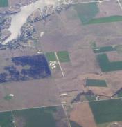
By: Dave


