Login
Register


46XS
Canadian River Ranch Airport
Official FAA Data Effective 2026-01-22 0901Z
VFR Chart of 46XS
Sectional Charts at SkyVector.com
IFR Chart of 46XS
Enroute Charts at SkyVector.com
Location Information for 46XS
Coordinates: N35°24.16' / W102°48.46'Located 11 miles NW of Adrian, Texas. View all Airports in Texas.
Estimated Elevation is 3839 feet MSL.
Operations Data
|
|
Airport Communications
| CTAF: | 122.900 |
|---|---|
| ASOS at DHT (39.3 N): | 134.075 806-249-5671 |
| AWOS-3 at HRX (40.3 SE): | 118.05 806-258-7283 |
| ASOS at TCC (41.2 W): | 119.275 575-461-4940 |
Nearby Navigation Aids
|
| ||||||||||||||||||||||||||||||||||||||||||


Runway 03/21
| Dimensions: | 4524 x 52 feet / 1379 x 16 meters | |
|---|---|---|
| Surface: | Asphalt in Good Condition | |
| Runway 03 | Runway 21 | |
Ownership Information
| Ownership: | Privately Owned | |
|---|---|---|
| Owner: | DAN A HUGHES | |
| 208 E HOUSTON ST, PO BOX 669 | ||
| BEEVILLE, TX 78104 | ||
| 361-358-3752 | ||
| Manager: | CASEY | |
| 1300 W RANCH RD | ||
| ADRIAN, T9 | ||
| 806-671-8252 | ||
Other Remarks
- OWNER DESIRES CHARTING
Nearby Airports with Instrument Procedures
| ID | Name | Heading / Distance | ||
|---|---|---|---|---|
 |
KDHT | Dalhart Municipal Airport | 018° | 39.2 |
|
KHRX | Hereford Municipal Airport | 143° | 40.2 |
|
KTCC | Tucumcari Municipal Airport | 251° | 41.2 |
|
KDUX | Moore County Airport | 054° | 47.5 |
|
KTDW | Tradewind Airport | 105° | 50.2 |
|
KAMA | Rick Husband Amarillo International Airport | 101° | 55.2 |
|
KCVN | Clovis Regional Airport | 192° | 60.0 |
|
KCAO | Clayton Municipal Airpark Airport | 345° | 64.7 |
|
KCVS | Cannon AFB Airport | 202° | 66.2 |
|
T45 | Panhandle-Carson County Airport | 091° | 70.8 |
|
KBGD | Hutchinson County Airport | 075° | 71.5 |
|
2T1 | Muleshoe Municipal Airport | 173° | 73.4 |
Airport Images
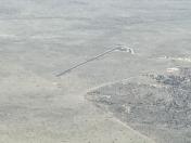
By: Big Orange Bird


